Gillsvannet
| Gillsvannet | |
|---|---|
| Gillsvann Gjelsvatnet | |
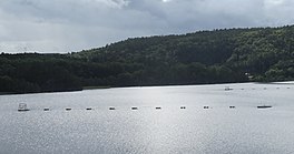 View of the lake | |
 Gillsvannet Location of the lake | |
| Location | Kristiansand, Agder |
| Coordinates | 58°11′15″N 8°01′24″E / 58.1874°N 08.0234°ECoordinates: 58°11′15″N 8°01′24″E / 58.1874°N 08.0234°E |
| Primary outflows | Topdalsfjorden |
| Basin countries | Norway |
| Max. length | 1.9 kilometres (1.2 mi) |
| Max. width | 1.5 kilometres (0.93 mi) |
| Surface area | 1.05 km2 (0.41 sq mi) |
| Surface elevation | 1 metre (3 ft 3 in) |
| References | NVE |


Gillsvannet or Gjelsvannet is a freshwater lake in the municipality of Kristiansand in Agder county, Norway.[1] The 1.05-square-kilometre (260-acre) lake is located about 5 kilometres (3.1 mi) northeast of downtown Kristiansand, along to County Road 452. The lake lies about 300 metres (980 ft) west of the Topdalsfjorden, at an elevation of about 1 metre (3 ft 3 in) above sea level. There is a practice range for kayaking on the lake as well as many areas used for swimming during the summer season.[2] The Gimlekollen district lies on the southern shore of the lake and the village of Justvik lies just north of the lake.
See also[]
- List of lakes in Norway
References[]
- ^ "Gillsvannet, Kristiansand (Agder)" (in Norwegian). yr.no. Retrieved 2017-02-10.
- ^ "Om flattvannsgruppa" (in Norwegian). Kristiansand kajakklubb. Retrieved 2017-02-10.
External links[]
- Kristiansand Gillsvannet Kristiansand Kajakk Klubb (in Norwegian)
Categories:
- Geography of Kristiansand
- Lakes of Agder