Glowe
Glowe | |
|---|---|
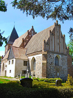 St. Paul's Church, Bobbin | |
 Coat of arms | |
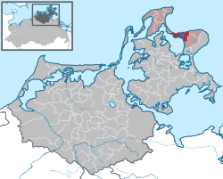
show Location of Glowe within Vorpommern-Rügen district | |
 Glowe | |
| Coordinates: 54°34′13″N 13°28′8″E / 54.57028°N 13.46889°ECoordinates: 54°34′13″N 13°28′8″E / 54.57028°N 13.46889°E | |
| Country | Germany |
| State | Mecklenburg-Vorpommern |
| District | Vorpommern-Rügen |
| Municipal assoc. | Nord-Rügen |
| Government | |
| • Mayor | Uwe Radeisen |
| Area | |
| • Total | 22.14 km2 (8.55 sq mi) |
| Elevation | 4 m (13 ft) |
| Population (2020-12-31)[1] | |
| • Total | 974 |
| • Density | 44/km2 (110/sq mi) |
| Time zone | UTC+01:00 (CET) |
| • Summer (DST) | UTC+02:00 (CEST) |
| Postal codes | 18551 |
| Dialling codes | 038302 |
| Vehicle registration | RÜG |
| Website | www.glowe.de |


Glowe is a municipality in the Vorpommern-Rügen district, in Mecklenburg-Vorpommern, Germany. It is a state-recognised resort.
Geography[]


Glowe lies about 18 kilometres north of Bergen auf Rügen and is located at the western end of the boundary between the Jasmund peninsula and the narrow land bridge of Schaabe between the Baltic Sea (the bay of Tromper Wiek) and the lagoon of Großer Jasmunder Bodden.
Municipal subdivisions[]
The municipality consists of the villages:
- Glowe
- Baldereck
- Kampe
- Bobbin
- Polchow
- Ruschvitz
- Spyker
History[]
Glowe was first documented in 1314. The name "Glowe" comes from the Slavic Gluowa or Glova and means something like "head", named after the 9-metre-high Königshörn, a small headland. The small parish grew up on and around the Königshörn.
The area was part of the Principality of Rügen until 1326 and thereafter the Duchy of Pomerania. Under the Treaty of Westphalia in 1648, Rügen, and thus the territory of Glowe, became part of Swedish Pomerania. In 1815, Glowe went, as part of New Western Pomerania, to the Prussian province of Pomerania. Since 1818, Glowe has been part of the county of Rügen.
As seaside resort tourism began to take off in the early 20th century, the former fishing village expanded more and more into the neighbouring woods of the Schaabewald.
From 1952-1955 Glowe was part of the county of Bergen. Thereafter the village became part of the county of Rügen again, this time in the district of Rostock until 1990, when it became part of the state of Mecklenburg-Western Pomerania. In 2011 the county of Rügen was merged into Vorpommern-Rügen.
Sights[]

- The Muschel ("mussel") in Glowe: a prestressed concrete building by Ulrich Müther in the shape of a mussel (until 1990 known as the Ostseeperle restaurant)
- Sea promenade and harbour in Glowe
- Spycker Castle, now a hotel once belonged to the Swedish field marshal and governor general of Swedish Pomerania, Carl Gustav Wrangel
- Lake Spycker
- Fishing village of Polchow with harbour
- Gothic fieldstone church of in Bobbin dating to the 14th century
- Dinosaur Land
- The DGzRS lifeboat, , is stationed in Glowe
References[]
- ^ "Statistisches Amt M-V – Bevölkerungsstand der Kreise, Ämter und Gemeinden 2020". Statistisches Amt Mecklenburg-Vorpommern (in German). July 2021.
External links[]
| Wikimedia Commons has media related to Glowe. |
 Glowe travel guide from Wikivoyage
- Official website of Glowe
| show Towns and municipalities in Vorpommern-Rügen |
|---|
| Authority control |
|---|
- Municipalities in Mecklenburg-Vorpommern
- Glowe
- Towns and villages on Rügen
- Bezirk Rostock