Gmina Polska Cerekiew
Gmina Polska Cerekiew
Gemeinde Groß Neukirch Polska Cerekiew Commune | |
|---|---|
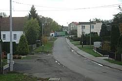 Road in Zakrzów | |
 Flag  Coat of arms | |
| Coordinates (Polska Cerekiew): 50°13′45″N 18°7′38″E / 50.22917°N 18.12722°ECoordinates: 50°13′45″N 18°7′38″E / 50.22917°N 18.12722°E | |
| Country | |
| Voivodeship | Opole |
| County | Kędzierzyn-Koźle |
| Seat | Polska Cerekiew |
| Area | |
| • Total | 60.85 km2 (23.49 sq mi) |
| Population (2019-06-30[1]) | |
| • Total | 4,021 |
| • Density | 66/km2 (170/sq mi) |
| Website | http://polskacerekiew.pl |

Gmina Polska Cerekiew, German Gemeinde Groß Neukirch is a rural gmina (administrative district) in Kędzierzyn-Koźle County, Opole Voivodeship, in south-western Poland. Its seat is the village of Polska Cerekiew (Groß Neukirch), which lies approximately 15 kilometres (9 mi) south of Kędzierzyn-Koźle and 51 km (32 mi) south of the regional capital Opole.
The gmina covers an area of 60.85 square kilometres (23.5 sq mi), and as of 2019 its total population is 4,021. Since 2011 the commune has been bilingual in German and Polish, and has its signs in two languages. These signs celebrate the multicultural past of the region, which was prior to 1945 part of Germany and still maintains a large German population.
Administrative divisions[]
The commune contains the villages and settlements of:
Neighbouring gminas[]
Gmina Polska Cerekiew is bordered by the gminas of Baborów and Rudnik.
Twin towns – sister cities[]
Gmina Polska Cerekiew is twinned with:[2]
 Rieste, Germany
 Světlá Hora, Czech Republic
Gallery[]
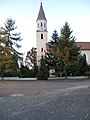
Church in Grzędzin

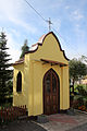
Ciężkowice


References[]
- ^ "Population. Size and structure and vital statistics in Poland by territorial division in 2019. As of 30th June". stat.gov.pl. Statistics Poland. 2019-10-15. Retrieved 2020-02-14.
- ^ "Home Page". polskacerekiew.pl (in Polish). Gmina Polska Cerekiew. Retrieved 2020-09-26.
| Wikimedia Commons has media related to Gmina Polska Cerekiew. |
| Urban gminas |
|  |
|---|---|---|
| Rural gminas | ||
- Gminas in Opole Voivodeship
- Kędzierzyn-Koźle County