Goesdorf
Goesdorf
Géisdref | |
|---|---|
Commune | |
 | |
 Coat of arms | |
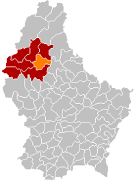 Map of Luxembourg with Goesdorf highlighted in orange, and the canton in dark red | |
| Coordinates: 49°55′00″N 5°58′00″E / 49.9167°N 5.9667°ECoordinates: 49°55′00″N 5°58′00″E / 49.9167°N 5.9667°E | |
| Country | |
| Canton | Wiltz |
| Area | |
| • Total | 29.41 km2 (11.36 sq mi) |
| Area rank | 27th of 102 |
| Highest elevation | 498 m (1,634 ft) |
| • Rank | 19th of 102 |
| Lowest elevation | 233 m (764 ft) |
| • Rank | 44th of 102 |
| Population (2018) | |
| • Total | 1,514 |
| • Rank | 87th of 102 |
| • Density | 51/km2 (130/sq mi) |
| • Density rank | 92nd of 102 |
| Time zone | UTC+1 (CET) |
| • Summer (DST) | UTC+2 (CEST) |
| LU0000804 | |
| Website | goesdorf.lu |

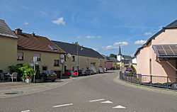
Goesdorf (German pronunciation: [ˈɡøːsˌdɔʁf]; Luxembourgish: Géisdref) is a commune and village in north-western Luxembourg. It is part of the canton of Wiltz.
As of 2005, the village of Goesdorf, which lies in the south of the commune, had a population of 238. Other towns within the commune include Buderscheid, Dahl, Nocher, and Nocher-Route.
References[]
External links[]
 Media related to Goesdorf at Wikimedia Commons
| show Places adjacent to Goesdorf |
|---|

| show Authority control |
|---|
This article related to the geography of Wiltz canton is a stub. You can help Wikipedia by . |
Categories:
- Villages in Luxembourg
- Communes in Wiltz (canton)
- Luxembourg geography stubs