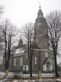
Gostyń, Silesian Voivodeship
Gostyń | |
|---|---|
Village | |
 Saints Peter and Paul church in Gostyń | |
 Coat of arms | |
 Gostyń | |
| Coordinates: 50°6′12″N 18°52′58″E / 50.10333°N 18.88278°E | |
| Country | |
| Voivodeship | Silesian |
| County | Mikołów |
| Gmina | Wyry |
| Population | 3,400 |
| Time zone | UTC+1 (CET) |
| • Summer (DST) | UTC+2 (CEST) |
Gostyń [ˈɡɔstɨɲ] (German Gostin) is a village in the administrative district of Gmina Wyry, within Mikołów County, Silesian Voivodeship, in southern Poland.[1] It lies approximately 5 kilometres (3 mi) south-west of Wyry, 8 km (5 mi) south of Mikołów, and 19 km (12 mi) south-west of the regional capital Katowice.
The village has a population of 3,400.
History[]

Gostyń was first established in the 13th or 14th century, when it was part of Piast-ruled fragmented Poland.[2] The village was abandoned in 1474, and reestablished in 1575.[2]
Part of Germany from 1871, in 1872 as part of Germanisation policies, German was introduced as a lecture language in the local school.[2] Gostyń was reintegrated with Poland, after the country regained independence in 1918 and the majority of the population voted for reintegration with Poland in the Upper Silesia plebiscite in 1921 (585 votes for Poland, 39 for Germany).[2] In the first days of the invasion of Poland, which started World War II, on September 1–3, 1939, Gostyń was the site of fierce Polish defense against invading Germany, in which 60% of the village was destroyed.[2] On September 2, 1939, the Germans murdered 13 Polish inhabitants of the village, including 4 women and the local parish priest.[3] After the defeat of Germany in 1945, the village was restored to Poland and a monument was erected at the site of the 1939 battle.[2]
There are two churches in the village: the Saints Peter and Paul church and the Exaltation of the Holy Cross church.
References[]
- ^ "Central Statistical Office (GUS) - TERYT (National Register of Territorial Land Apportionment Journal)" (in Polish). 2008-06-01.
- ^ Jump up to: a b c d e f "Historia". Portal gminy Wyry (in Polish). Retrieved 14 March 2020.
- ^ Maria Wardzyńska, Był rok 1939. Operacja niemieckiej policji bezpieczeństwa w Polsce. Intelligenzaktion, IPN, Warszawa, 2009, p. 134 (in Polish)
| Wikimedia Commons has media related to Gostyń, Silesian Voivodeship. |
Coordinates: 50°6′12″N 18°52′58″E / 50.10333°N 18.88278°E
- Villages in Mikołów County
- Silesian geography stubs

