Grade II* listed buildings in Nottinghamshire

Nottinghamshire shown within England
There are over 20,000 Grade II* listed buildings in England. This page is a list of these buildings in the county of Nottinghamshire, by district.
Ashfield[]
| Name | Location | Type | Completed [note 1] | Date designated | Grid ref.[note 2] Geo-coordinates |
Entry number [note 3] | Image |
|---|---|---|---|---|---|---|---|
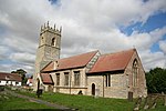
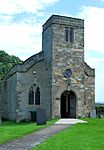
| Church of All Saints | Annesley | Statue | 1832 | 12 October 1988 | SK5109953620 53°04′39″N 1°14′19″W / 53.077371°N 1.238687°W |
1275939 |  |
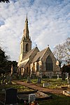
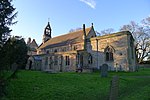
| Church of St Helen | Selston | Tower | Late 14th century | 13 October 1966 | SK4583453308 53°04′30″N 1°19′02″W / 53.075043°N 1.317316°W |
1275170 |  |
| Church of St Mary Magdalene | Hucknall | Tower | 1925 | 12 October 1988 | SK5334649381 53°02′21″N 1°12′21″W / 53.039051°N 1.205849°W |
1217611 |  |
| Church of St Mary Magdalene | Sutton-in-Ashfield | Tower | c. 1395 | 4 June 1980 | SK4894058959 53°07′32″N 1°16′12″W / 53.125561°N 1.2701°W |
1221773 |  |
Bassetlaw[]


Broxtowe[]


City of Nottingham[]
| Name | Location | Type | Completed [note 1] | Date designated | Grid ref.[note 2] Geo-coordinates |
Entry number [note 3] | Image |
|---|---|---|---|---|---|---|---|
| Adams Building and Attached Railings | Lace Market | Workshop | 1995 | 12 July 1972 | SK5762639840 52°57′10″N 1°08′37″W / 52.952852°N 1.143723°W |
1270430 |  |
| Albert Ball Memorial Homes | Lenton | Almshouses | 1922 | 30 November 1995 | SK5531339114 52°56′48″N 1°10′42″W / 52.946569°N 1.1782699°W |
1246781 |  |
| Arkwright Building, Nottingham Trent University | Nottingham | Public Library | 1877-81 | 12 July 1972 | SK5703840324 52°57′26″N 1°09′09″W / 52.957265°N 1.152389°W |
1255017 |  |
| Boots D90 West Headquarters Building | Nottingham | Courtyard | 1966-1968 | 28 August 1996 | SK5497436919 52°55′37″N 1°11′01″W / 52.926875°N 1.183686°W |
1268303 | 
|
| Bromley House | Nottingham | Town House | 1752 | 11 August 1952 | SK5704439910 52°57′13″N 1°09′09″W / 52.953543°N 1.152372°W |
1246247 |
|
| Camellia House 100 Metres South West of Wollaton Hall | Wollaton Park | Camellia House | 1823 | 12 July 1972 | SK5321339139 52°56′49″N 1°12′34″W / 52.947006°N 1.209515°W |
1255271 |  |
| Cathedral Church of St Barnabas and Attached Boundary Wall | Nottingham | Boundary Wall | 1841-44 | 11 August 1952 | SK5672040028 52°57′17″N 1°09′26″W / 52.954638°N 1.157173°W |
1247533 |  |
| Church of Holy Trinity | Lenton | Parish Church | 1842 | 30 November 1995 | SK5545539310 52°56′54″N 1°10′34″W / 52.948316°N 1.176123°W |
1247151 | 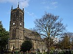 |
| Church of St Andrew and Boundary Wall | Nottingham | Gate | 1869-71 | 12 July 1972 | SK5703441190 52°57′54″N 1°09′08″W / 52.965049°N 1.152296°W |
1058983 |  |
| Church of St Leodegarius and Attached Grave Enclosure | Basford | Tower | Rebuilt 1859-61 | 29 April 1964 | SK5529742774 52°58′46″N 1°10′40″W / 52.979468°N 1.177884°W |
1271037 |  |
| Church of St Leonard and Attached Boundary Wall | Wollaton | Parish Church | c. 1200 | 11 August 1952 | SK5249239790 52°57′11″N 1°13′13″W / 52.952928°N 1.220139°W |
1255283 |  |
| Church of St Martin | Bilborough | Tower | c. 1450 | 29 April 1964 | SK5202041811 52°58′16″N 1°13′37″W / 52.97114°N 1.22684°W |
1255110 |  |
| Church of St Nicholas | Nottingham | Tower | 1906 | 11 August 1952 | SK5714539565 52°57′02″N 1°09′03″W / 52.950431°N 1.15093°W |
1270639 | 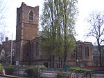 |
| Church of St Wilfrid | Wilford | Tower | Late 15th century | 29 April 1964 | SK5663337797 52°56′05″N 1°09′32″W / 52.934594°N 1.158857°W |
1271049 |  |
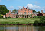
| Colwick Hall | Colwick | Country House | Early 18th century | 11 August 1952 | SK6017639027 52°56′43″N 1°06′21″W / 52.945265°N 1.105923°W |
1254981 |  |
| Council House, Exchange Buildings and Adjoining Shops and Bank | Old Market Square | Council House | 1924-29 | 4 February 1988 | SK5730939900 52°57′12″N 1°08′54″W / 52.953425°N 1.14843°W |
1270582 |  |
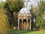
| Doric Temple and Attached Bridge 200 Metres South-east of Wollaton Hall | Wollaton Park | Bridge | Early 19th century | 10 August 1989 | SK5337539174 52°56′50″N 1°12′26″W / 52.947304°N 1.207099°W |
1270389 | 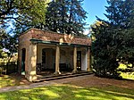 |
| Elite Building | Nottingham | Shop | 1921 | 12 July 1972 | SK5722240058 52°57′17″N 1°08′59″W / 52.954854°N 1.149697°W |
1254539 | 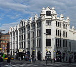 |
| Enfield House and attached Area Wall | Nottingham | Town House | Mid 18th century | 11 August 1952 | SK5737039675 52°57′05″N 1°08′51″W / 52.951396°N 1.147562°W |
1270637 |
|
| Former Police Station adjoining Shire Hall | Lace Market, Nottingham | Gate | 1905 | 12 July 1972 | SK5756239612 52°57′03″N 1°08′41″W / 52.950809°N 1.144716°W |
1247636 |  |
| Gate and Railings to Forecourt of Number 24 and 26 Low Pavement | Nottingham | Gate | c. 1733 | 12 July 1972 | SK5739739679 52°57′05″N 1°08′50″W / 52.951429°N 1.147159°W |
1270638 |
|
| Habitat and Rj's Homeshop | Nottingham | Merchants House | c. 1720 | 11 May 1988 | SK5706339951 52°57′14″N 1°09′07″W / 52.95391°N 1.152082°W |
1254555 |  |
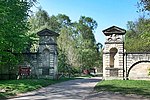
| Lenton Lodge (former Gateway to Wollaton Park) and attached Bollards | Nottingham | Gate Lodge | 1823-25 | 11 August 1952 | SK5483839187 52°56′50″N 1°11′07″W / 52.947274°N 1.185326°W |
1270829 |  |
| Lenton War Memorial | Lenton | War memorial | 1823-25 | 30 November 1995 | SK5529039094 52°56′47″N 1°10′43″W / 52.946392°N 1.1786155°W |
1246782 |  |
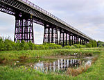
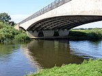
| Midland Railway Station | Nottingham | Footbridge | 1904 | 12 July 1972 | SK5744539204 52°56′50″N 1°08′48″W / 52.947155°N 1.146529°W |
1271301 | 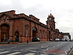 |
| Newdigate House and Attached Railings and Boundary Wall | Nottingham | House | c. 1675 | 11 August 1952 | SK5705939600 52°57′03″N 1°09′08″W / 52.950755°N 1.152203°W |
1271185 |  |
| Newton Building at Nottingham Trent University | Nottingham | Polytechnic | 1956-1958 | 24 April 1998 | SK5706340228 52°57′23″N 1°09′07″W / 52.956399°N 1.152033°W |
1323704 |  |
| Nottingham Playhouse | Nottingham | Theatre | 1961-3 | 14 July 1994 | SK5679639939 52°57′14″N 1°09′22″W / 52.95383°N 1.156058°W |
1255252 | 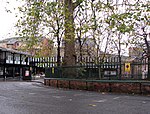 |
| People's Hall | Nottingham | House | 1750 | 12 July 1972 | SK5766540002 52°57′15″N 1°08′35″W / 52.954304°N 1.143114°W |
1254499 |  |
| Railings and Gate to Forecourt at Willoughby House | Nottingham | Gate | c. 1743 | 12 July 1972 | SK5737939681 52°57′05″N 1°08′51″W / 52.951449°N 1.147427°W |
1254748 |
|
| Sheriff House | Nottingham | Town House | 1768 | 11 August 1952 | SK5692639748 52°57′08″N 1°09′15″W / 52.9521°N 1.154157°W |
1270499 |
|
| Shire Hall and Adjoining County Gaol | Lace Market | Gate | 1770-72 | 24 October 1988 | SK5759239606 52°57′03″N 1°08′39″W / 52.950752°N 1.14427°W |
1254517 |  |
| Willoughby House | Nottingham | Town House | c. 1738 | 11 August 1952 | SK5738139665 52°57′05″N 1°08′51″W / 52.951305°N 1.1474°W |
1254559 |
|
| 24 and 26 Low Pavement | Nottingham | Town House | c. 1733 | 11 August 1952 | SK5739739671 52°57′05″N 1°08′50″W / 52.951357°N 1.147161°W |
1254560 |
|
| 19 Castle Gate | Nottingham | Town House | 1775 | 11 August 1952 | SK5720439648 52°57′04″N 1°09′00″W / 52.951171°N 1.150037°W |
1246653 |
|
| 56 Village Road | Clifton | Aisled House | 14th century | 14 April 1954 | SK5446434997 52°54′35″N 1°11′30″W / 52.909651°N 1.191593°W |
1255237 |
|
Gedling[]
| Name | Location | Type | Completed [note 1] | Date designated | Grid ref.[note 2] Geo-coordinates |
Entry number [note 3] | Image |
|---|---|---|---|---|---|---|---|
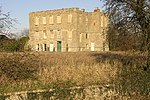
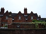
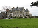
| Bestwood Lodge Hotel and Terrace Wall | Bestwood Park, Bestwood St. Albans | Country House | 1862 | 13 December 1972 | SK5695246506 53°00′46″N 1°09′09″W / 53.012839°N 1.152582°W |
1227444 |  |
| Bestwood Pumping Station | Bestwood St. Albans | Coal Shed | 1871-1874 | 5 September 1972 | SK5792848246 53°01′42″N 1°08′16″W / 53.028374°N 1.137725°W |
1265233 |  |
| Emmanuel Church | Bestwood St. Albans | Parish Church | 1868 | 27 April 1987 | SK5663046423 53°00′44″N 1°09′27″W / 53.012127°N 1.157396°W |
1235441 |  |
| Winding House and Headstocks at Bestwood Colliery | Bestwood St. Albans | Colliery | Late 19th century | 27 April 1987 | SK5563947460 53°01′18″N 1°10′19″W / 53.021552°N 1.171986°W |
1235186 |  |
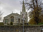
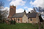
| Church of St Wilfrid | Calverton | Tower | 1763 | 13 October 1966 | SK6174049184 53°02′11″N 1°04′51″W / 53.036379°N 1.080716°W |
1235903 |  |
| Brewhouse, Crewyard and Mill Barn at Hall Farmhouse | Linby | Brewhouse | Late 18th century | 27 April 1987 | SK5338051135 53°03′17″N 1°12′18″W / 53.054813°N 1.205052°W |
1265319 |
|
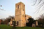
| Church of St Michael | Linby | Tower | 13th century | 13 October 1966 | SK5345350892 53°03′09″N 1°12′14″W / 53.052622°N 1.204004°W |
1265318 |  |
| Boatswain's Monument 30m north-east of Newstead Abbey | Newstead Park, Newstead | Commemorative Monument | 1808 | 13 October 1966 | SK5423053785 53°04′43″N 1°11′31″W / 53.078546°N 1.191927°W |
1264302 |  |
| The Cannon Fort and adjoining Dock | Newstead Park, Newstead | Dock | c. 1750 | 13 October 1966 | SK5376053823 53°04′44″N 1°11′56″W / 53.078935°N 1.198936°W |
1264406 |
|
| Engine House, Boiler House and Workshop at Papplewick Pumping Station | Ravenshead | Boiler House | 1881 | 18 October 1971 | SK5827452136 53°03′48″N 1°07′55″W / 53.0633°N 1.131865°W |
1265301 |  |
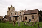
| Church of St Swithun | Woodborough | Tower | 13th century | 13 October 1966 | SK6315147711 53°01′23″N 1°03′36″W / 53.022976°N 1.059964°W |
1264188 |  |
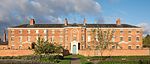
| Woodborough Hall | Woodborough | House | circa 1660 | 15 July 1985 | SK6251447760 53°01′25″N 1°04′10″W / 53.023491°N 1.06945°W |
1227555 |
|
| Church of the Good Shepherd | Arnold | Roman Catholic Church | 1962-1964 | 25 September 1998 | SK5805844326 52°59′35″N 1°08′11″W / 52.993126°N 1.13649°W |
1376603 |  |
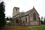
| Church of St Mary | Arnold | Tower | 14th century | 24 January 1950 | SK5868446146 53°00′34″N 1°07′37″W / 53.009417°N 1.126835°W |
1235987 |  |
| Church of St Paul | Daybrook | Parish Church | 1892-96 | 27 April 1987 | SK5796645158 53°00′02″N 1°08′16″W / 53.000614°N 1.137712°W |
1236096 |  |
Mansfield[]
| Name | Location | Type | Completed [note 1] | Date designated | Grid ref.[note 2] Geo-coordinates |
Entry number [note 3] | Image |
|---|---|---|---|---|---|---|---|
| Warsop Parish Centre | Warsop | Farmhouse | 15th century | 28 August 1962 | SK5674468837 53°12′49″N 1°09′06″W / 53.213572°N 1.151742°W |
1251896 |  |
| Cavendish Monument and attached Railings | Mansfield | Commemorative Monument | 1849 | 17 March 1978 | SK5384161092 53°08′39″N 1°11′47″W / 53.144262°N 1.19651°W |
1207176 |  |
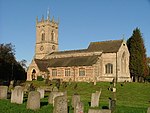
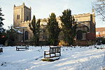
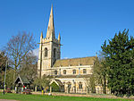
| Church of St Edmund | Mansfield Woodhouse | Parish Church | 1304 | 28 January 1957 | SK5401763212 53°09′48″N 1°11′37″W / 53.163299°N 1.193522°W |
1251828 | 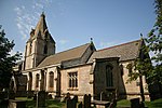 |
| Church of St Mark and attached Boundary Wall | Mansfield | Parish Church | 1897 | 21 March 1994 | SK5377060448 53°08′19″N 1°11′52″W / 53.13848°N 1.197679°W |
1214953 |  |
| Innisdoon and attached Garden Wall and Gate Piers | Mansfield | Arts and Crafts house and coach house | 1904-05 | 7 October 1977 | SK5361461615 53°08′56″N 1°11′59″W / 53.148985°N 1.199816°W |
1214391 |  |
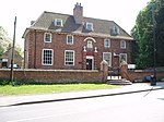
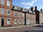
| St Peter's House | Mansfield | House | Late 17th century | 19 December 1955 | SK5406961059 53°08′38″N 1°11′35″W / 53.143942°N 1.193107°W |
1213928 |  |
| The Old Meeting House | Mansfield | Unitarian Chapel | 1702 | 19 December 1955 | SK5360461143 53°08′41″N 1°12′00″W / 53.144744°N 1.200044°W |
1207181 |  |
| The Old Town Hall and attached Piers and Railings | Mansfield | Civic building (1835-1836)[1] | 1836 | 17 March 1978 | SK5382461046 53°08′38″N 1°11′48″W / 53.14385°N 1.196772°W |
1207179 |  |
| The Priory | Mansfield Woodhouse | House | 20th century | 28 January 1957 | SK5376163204 53°09′48″N 1°11′50″W / 53.163252°N 1.197352°W |
1251852 |  |
| Waverley House | Mansfield | House | 1754 | 19 December 1955 | SK5369861217 53°08′43″N 1°11′55″W / 53.1454°N 1.198627°W |
1288092 |  |
Newark and Sherwood[]


Rushcliffe[]


See also[]
Category:Grade II* listed buildings in Nottinghamshire
Notes[]
- ^ a b c d e f g h The date given is the date used by Historic England as significant for the initial building or that of an important part in the structure's description.
- ^ a b c d e f g h Sometimes known as OSGB36, the grid reference is based on the British national grid reference system used by the Ordnance Survey.
- ^ a b c d e f g h The "List Entry Number" is a unique number assigned to each listed building and scheduled monument by Historic England.
References[]
- ^ 1835 The foundation stone of the Mansfield Town Hall was laid by Mr. John Coke. 1836 The Town Hall was opened for the first time. ourmansfieldandarea.org (Mansfield District Council Museum), Retrieved 13 February 2020
National Heritage List for England
External links[]
![]() Media related to Grade II* listed buildings in Nottinghamshire at Wikimedia Commons
Media related to Grade II* listed buildings in Nottinghamshire at Wikimedia Commons
Categories:
- Grade II* listed buildings in Nottinghamshire
- Lists of Grade II* listed buildings in England by county
- Lists of listed buildings in Nottinghamshire