Grade II* listed buildings in the West Midlands

The West Midlands shown in England
There are over 20,000 Grade II* listed buildings in England. This page is a list of these buildings in the county of West Midlands, by district.
Birmingham[]


City of Wolverhampton[]
| Name | Location | Type | Completed [note 1] | Date designated | Grid ref.[note 2] Geo-coordinates |
Entry number [note 3] | Image |
|---|---|---|---|---|---|---|---|
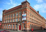
| Wolverhampton Art Gallery and Museum | Wolverhampton | Art Gallery | 1883-5 | 12 February 1975 | SO9149898773 52°35′12″N 2°07′37″W / 52.586694°N 2.126921°W |
1201828 |  |
| Catholic Church of St Mary and St John | Wolverhampton | Roman Catholic Church | 1851-5 | 16 July 1949 | SO9160698206 52°34′54″N 2°07′31″W / 52.581598°N 2.125312°W |
1208140 |  |
| Catholic Church of St Peter and St Paul | Wolverhampton | Roman Catholic Church | 1826-1828 | 16 July 1949 | SO9125798890 52°35′16″N 2°07′50″W / 52.587742°N 2.130481°W |
1201844 |  |
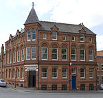
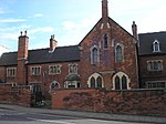
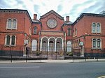
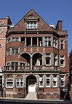
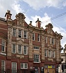
| Central Library | Wolverhampton | Public Library | 1900-1902 | 3 February 1977 | SO9161998376 52°34′59″N 2°07′30″W / 52.583127°N 2.125125°W |
1201811 | 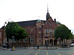 |
| Church of St Bartholemew | Penn | Church | 14th century | 3 February 1977 | SO8945295281 52°33′19″N 2°09′25″W / 52.555265°N 2.157007°W |
1201886 |  |
| Church of St John | Wolverhampton | Anglican Church | 1758-76 | 3 February 1977 | SO9142698162 52°34′52″N 2°07′41″W / 52.5812°N 2.127967°W |
1201864 |  |
| Church of St Luke | Wolverhampton | Church | 1860-1 | 31 March 1992 | SO9132197172 52°34′20″N 2°07′46″W / 52.572298°N 2.129491°W |
1293038 |  |
| Church of St Mary | Wolverhampton | Bust | 19th century | 16 July 1949 | SJ9244702469 52°37′12″N 2°06′47″W / 52.619934°N 2.112999°W |
1201786 |  |
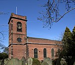
| Church of St Mary | Bilston | Church | 1827-9 | 3 February 1977 | SO9548296232 52°33′50″N 2°04′05″W / 52.563899°N 2.068082°W |
1201850 |  |
| County Court | Wolverhampton | Assembly Rooms | 1829 | 3 February 1977 | SO9168398643 52°35′08″N 2°07′27″W / 52.585528°N 2.124187°W |
1207819 |  |
| Giffard House | Wolverhampton | House | Mid 19th century | 16 July 1949 | SO9127198898 52°35′16″N 2°07′49″W / 52.587814°N 2.130275°W |
1282478 |  |
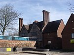
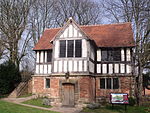
| Graisley Old Hall | Wolverhampton | House | Late 15th century | 16 September 1957 | SO9052497334 52°34′25″N 2°08′29″W / 52.573741°N 2.141255°W |
1205291 | 
|
| Grand Theatre | Wolverhampton | Theatre | 1893-4 | 12 February 1975 | SO9168498746 52°35′11″N 2°07′27″W / 52.586454°N 2.124175°W |
1282471 |  |
| Greyhound and Punchbowl Inn | Bilston | Jettied House | Mid 16th century, possibly earlier | 20 June 1952 | SO9462496244 52°33���50″N 2°04′51″W / 52.563999°N 2.08074°W |
1201819 |  |
| Methodist Church | Wolverhampton | Parish Hall | 1870s | 3 February 1977 | SO9114698594 52°35′06″N 2°07′56″W / 52.585079°N 2.132111°W |
1201807 |
|
| Molineux Hotel | Wolverhampton | House | circa 1720 | 16 July 1949 | SO9131599188 52°35′26″N 2°07′47″W / 52.590422°N 2.129633°W |
1282475 |
|
| Moseley Hall | Wolverhampton | House | Early 18th century | 16 July 1949 | SJ9305103977 52°38′01″N 2°06′15″W / 52.633499°N 2.10411°W |
1298757 |  |
| Old Fallings Hall (our Lady and St Chad Roman Catholic School) | Wolverhampton | House | Early 18th century and possibly earlier | 16 July 1949 | SJ9280401456 52°36′39″N 2°06′28″W / 52.610832°N 2.107704°W |
1201846 |
|
| Old Malt House to North of Wightwick Manor | Wolverhampton | Malt House | Late 16th century or early 17th century | 29 July 1950 | SO8695698465 52°35′02″N 2°11′38″W / 52.583834°N 2.193947°W |
1208976 |
|
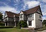
| Penn Hall | Penn | House | Late 17th century | 16 July 1949 | SO8910395402 52°33′23″N 2°09′44″W / 52.556346°N 2.162158°W |
1282460 |
|
| Tettenhall Towers | Tettenhall | House | circa 1770 | 29 July 1950 | SO8863499755 52°35′44″N 2°10′09″W / 52.595469°N 2.169227°W |
1201906 |
|
| The Old House | Tettenhall | House | 1995 | 29 July 1950 | SO8879599920 52°35′49″N 2°10′01″W / 52.596955°N 2.166856°W |
1205595 |
|
Coventry[]
Dudley[]
| Name | Location | Type | Completed [note 1] | Date designated | Grid ref.[note 2] Geo-coordinates |
Entry number [note 3] | Image |
|---|---|---|---|---|---|---|---|
| Brown Bear Ravine at Dudley Zoo (including All Associated Structures) | Dudley | Bear Enclosure | 1935-1937 | 20 August 1970 | SO9480490913 52°30′58″N 2°04′41″W / 52.516076°N 2.077999°W |
1227748 |
|
| Church of All Saints | Dudley | Church | Rebuilt 1826-9 | 11 August 1950 | 52°32′26″N 2°07′22″W / 52.5405°N 2.1229°W | 1279405 |  |
| Church of St Edmund | Dudley | Parish Church | circa 1724 | 14 September 1949 | SO9464790451 52°30′43″N 2°04′49″W / 52.511921°N 2.080305°W |
1287455 |  |
| Drinking Fountain | Dudley | Drinking Fountain | 1867 | 14 September 1949 | SO9449890278 52°30′37″N 2°04′57″W / 52.510364°N 2.082498°W |
1343214 |
|
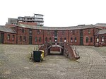
| Entrance Gateway at Dudley Zoo | Dudley | Zoo | 1935-1937 | 20 August 1970 | SO9482690596 52°30′48″N 2°04′40″W / 52.513226°N 2.07767°W |
1216535 |
|
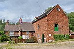
| Fan House and Chimney at the Former New Hawne Colliery | Halesowen | Colliery | 1865 | 8 October 1975 | SO9569784632 52°27′35″N 2°03′53″W / 52.459618°N 2.064756°W |
1063766 |
|
| Glass Cone at Stuart and Sons Red House Glassworks | Wordsley | Glass furnace cone | 18th century | 23 September 1966 | SO8943386486 52°28′34″N 2°09′25″W / 52.476199°N 2.157005°W |
1076007 |  |
| Holbeache House | Kingswinford | House | circa 1600 | 14 June 1951 | SO8847090490 52°30′44″N 2°10′17″W / 52.512175°N 2.171323°W |
1228293 |
|
| Kiosk to East of Former Brown Bear Pit at Dudley Zoo | Dudley | Kiosk | 1935-1937 | 20 August 1970 | SO9482090920 52°30′58″N 2°04′40″W / 52.516139°N 2.077763°W |
1076024 |
|
| Kiosk to South of Bear Pit at Dudley Zoo | Dudley | Kiosk | 1935-1937 | 20 August 1970 | SO9459490657 52°30′50″N 2°04′52″W / 52.513772°N 2.081089°W |
1227903 |
|
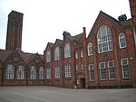
| Old Swinford Hospital | Dudley | School | 1667 | 8 November 1949 | SO9029583652 52°27′03″N 2°08′39″W / 52.450737°N 2.14423°W |
1076037 |
|
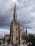
| Parish Church of St Thomas | Dudley | Parish Church | 1815-18 | 14 September 1949 | SO9421790082 52°30′31″N 2°05′12″W / 52.508599°N 2.086634°W |
1075998 |  |
| Polar Bear Pit and Lion and Tiger Ravines, Dudley Zoo | Dudley | Wild Cat Enclosure | 1935-1937 | 20 August 1970 | SO9460490706 52°30′51″N 2°04′51″W / 52.514213°N 2.080943°W |
1076027 |  |
| The Grange | Dudley | House | Early-mid 18th century | 10 January 1950 | SO9704482821 52°26′36″N 2°02′42″W / 52.443346°N 2.044916°W |
1063763 |
|
| The Old Foundry | Dudley | Fireproof Building | 1820 | 8 March 1983 | SO8946984770 52°27′39″N 2°09′23″W / 52.460773°N 2.15642°W |
1262873 |  |
| The Town Hall, Coroner's Court, Former Sessions Court and Brooke Robinson Museum | Dudley | Tower | 1924-1928 | 14 May 2010 | SO9436190407 52°30′41″N 2°05′04″W / 52.511523°N 2.084518°W |
1393884 |
|
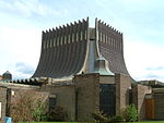
| Tropical Bird House at Dudley Zoo | Dudley | Aviary | 1935-1937 | 20 August 1970 | SO9472990942 52°30′59″N 2°04′45″W / 52.516336°N 2.079105°W |
1227761 |  |
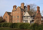
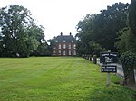
| Wordsley Manor | Wordsley | Country House | Late 18th century | 9 April 1976 | SO8917786488 52°28′34″N 2°09′39″W / 52.476212°N 2.160774°W |
1228358 |
|
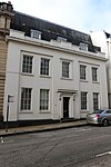
| 29 & 30 Wolverhampton Street | Dudley | House | 1707 | 14 September 1949 | SO9422490286 52°30′38″N 2°05′12″W / 52.510433°N 2.086535°W |
1228896 |
|
| Stourbridge War Memorial | Stourbridge | War memorial | 1923 | 30 October 1989 | SO8985083533 52°26′59″N 2°09′03″W / 52.449659°N 2.1507744°W |
1116647 |  |
Sandwell[]


Solihull[]


Walsall[]
| Name | Location | Type | Completed [note 1] | Date designated | Grid ref.[note 2] Geo-coordinates |
Entry number [note 3] | Image |
|---|---|---|---|---|---|---|---|
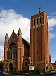
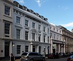
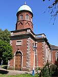
| Church of St Mary and Attached Presbytery | Walsall | Church | 1825 | 31 July 1986 | SP0121698031 52°34′48″N 1°59′01″W / 52.58009°N 1.983487°W |
1077171 | 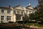 |
| Church of St Mary the Virgin | Brownhills | Church | 14th century | 11 August 1951 | SK0601400735 52°36′16″N 1°54′45″W / 52.604368°N 1.912632°W |
1076396 | 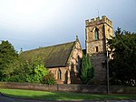 |
| Church of St Matthew | Walsall | Church | Late 15th century | 19 November 1951 | SP0163998293 52°34′57″N 1°58′38″W / 52.582445°N 1.977244°W |
1116151 |  |
| Gatehouse and Curtain Walls at Rushall Hall | Rushall | Gate | circa 1300 | 19 October 1951 | SP0254399865 52°35′48″N 1°57′50″W / 52.596573°N 1.96389°W |
1320329 |
|
| Great Barr Hall and Chapel | Great Barr | House | 1777 | 15 June 1971 | SP0546595385 52°33′23″N 1°55′15″W / 52.556278°N 1.920825°W |
1076395 |
|
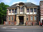
| Guildhall | Walsall | Guildhall | 1867 | 13 September 1982 | SP0152898378 52°35′00″N 1°58′44″W / 52.583209°N 1.978881°W |
1076399 |  |
See also[]
- Category:Grade II* listed buildings in the West Midlands (county)
- Grade I listed buildings in the West Midlands#Birmingham
- Listed pubs in Birmingham
Notes[]
- ^ a b c d e f The date given is the date used by Historic England as significant for the initial building or that of an important part in the structure's description.
- ^ a b c d e f Sometimes known as OSGB36, the grid reference is based on the British national grid reference system used by the Ordnance Survey.
- ^ a b c d e f The "List Entry Number" is a unique number assigned to each listed building and scheduled monument by Historic England.
References[]
National Heritage List for England
External links[]
![]() Media related to Grade II* listed buildings in the West Midlands (county) at Wikimedia Commons
Media related to Grade II* listed buildings in the West Midlands (county) at Wikimedia Commons
Categories:
- Lists of Grade II* listed buildings in England by county
- Grade II* listed buildings in the West Midlands (county)
- Lists of listed buildings in the West Midlands (county)