Grassy Ridge Bald
| Grassy Ridge Bald | |
|---|---|
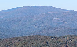 Grassy Ridge Bald viewed from Grandfather Mountain | |
| Highest point | |
| Elevation | 6,184 ft (1,885 m)[1] |
| Prominence | 688 ft (210 m)[2] |
| Parent peak | Roan High Knob[2] |
| Coordinates | 36°05′59″N 82°04′49″W / 36.0998357°N 82.0803954°W[1] |
| Geography | |
| Location | Avery & Mitchell counties North Carolina, U.S. |
| Parent range | |
| Topo map | USGS Carvers Gap |
| Climbing | |
| Easiest route | Hike |

Grassy Ridge Bald is a mountain in North Carolina and is part of the Roan Highlands, within the Pisgah National Forest. Its elevation reaches 6,184 feet (1,885 m) and is on the boundary between Avery County, North Carolina (highest point) and Mitchell County, North Carolina. The mountain generates feeder streams for the North Toe River.[citation needed]
See also[]
References[]
- ^ Jump up to: a b "Grassy Ridge Bald". Geographic Names Information System. United States Geological Survey. Retrieved 2019-07-15.
- ^ Jump up to: a b "Grassy Ridge Bald, North Carolina". Peakbagger.com. Retrieved 2019-07-15.
Categories:
- Mountains of North Carolina
- Southern Sixers
- Mountains of Avery County, North Carolina
- Landforms of Mitchell County, North Carolina
- Mountains on the Appalachian Trail