Waterrock Knob
| Waterrock Knob | |
|---|---|
 Waterrock Knob viewed from the Blue Ridge Parkway | |
| Highest point | |
| Elevation | 6,292 ft (1,918 m) |
| Prominence | 1,947 ft (593 m) |
| Coordinates | 35°27′51″N 83°08′16″W / 35.464268°N 83.137643°WCoordinates: 35°27′51″N 83°08′16″W / 35.464268°N 83.137643°W |
| Geography | |
| Location | Haywood / Jackson Counties, North Carolina, U.S. |
| Parent range | Plott Balsams Blue Ridge Mountains |
| Topo map | USGS Sylva North |
| Climbing | |
| Easiest route | Hike |

Waterrock Knob[1] is a mountain peak in the U.S. state of North Carolina.[2] It is the highest peak in the Plott Balsams and is the 16th-highest mountain in the Eastern United States.[3]
The mountain is a popular destination with tourists and amateur hikers, as it is easily accessible from the parkway. A visitors' center is located near its summit and a hiking trail leads to its top. The hiking trail and visitors' center are manned and maintained by the National Park Service, part of the United States Department of the Interior.
Name[]
Waterrock Knob is named as such because of a spring located near the summit where hunters would refill their canteens.[4][5]
Geography[]
With an elevation of 6,292 feet (1,918 m), Waterrock Knob is the highest peak in the Plott Balsams and is the 13th-highest mountain in the Eastern United States if using a 160 feet (49 m) prominence rule.[3][6]
The mountain is split by both Haywood and Jackson counties in the western mountains of North Carolina. The mountain's summit is located within the Blue Ridge Parkway National Park Service unit. Cherokee is located about 10 miles (16 km) to the west, while Richland Balsam is located about 10 miles (16 km) to the southeast.[7]
Hiking[]
Waterrock Knob's summit can be accessed from the Waterrock Knob Visitor Center, located a milepost 451.2 on the Blue Ridge Parkway. This 0.6 miles (0.97 km) long trail ascends over 400 feet (120 m) from visitor center's parking lot and is paved for the first quarter mile.[8][9]
Images[]

From the visitor center parking lot

Taken from the summit of Waterrock Knob
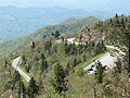
View of the Waterrock Knob parking lot and the Blue Ridge Parkway from the summit of Waterrock Knob
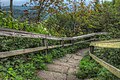
Waterrock Knob Trail


See also[]
References[]
- ^ U.S. Geological Survey Geographic Names Information System: Waterrock Knob
- ^ "Geographic Names Information System Feature Detail Report: Waterrock Knob". Retrieved 2007-07-11.
- ^ a b "Peakbagger.com - Southern Appalachian 6000-foot Peaks". Retrieved 2007-07-09.
- ^ Powell, William. The North Carolina Gazetteer, 2nd Ed. Univ of North Carolina Press. (2010). pp. 551. ISBN 9780807898291.
- ^ Lemon, Cindy. Southern Appalachian Day Hikes. (2015). ISBN 9781329597389.
- ^ "Waterrock Knob, North Carolina". Peakbagger.com. Retrieved 2017-09-10.
- ^ United States Geological Survey (10 September 2017). Waterrock Knob, NC quadrangle (Topographic map). Reston, VA: United States Geological Survey. Retrieved 10 September 2017 – via TopoQuest.
- ^ Waterrock Knob, Milepost 451.2. Virtual Blue Ridge. Retrieved 10 September 2017.
- ^ Jabado, Salwa. Fodor's The Carolinas and Georgia. (2009). Fodor's Travel Publications. pp. 169. ISBN 9781400008087.
| Wikimedia Commons has media related to Waterrock Knob. |
- Mountains of North Carolina
- Southern Sixers
- Landmarks in North Carolina
- Protected areas of Jackson County, North Carolina
- Protected areas of Haywood County, North Carolina
- Blue Ridge Parkway
- Landforms of Jackson County, North Carolina
- Mountains of Haywood County, North Carolina
- Western North Carolina geography stubs