Greater Poland
This article needs additional citations for verification. (April 2014) |
Greater Poland
Wielkopolska | |
|---|---|
Historical region | |
 Coat of arms | |
 The proper Greater Poland | |
| Country | |
| Seat | Gniezno, Poznań, Kalisz |
| Time zone | UTC+1 (CET) |
| • Summer (DST) | UTC+2 (CEST) |

Greater Poland, often known by its Polish name Wielkopolska ([vʲɛlkɔˈpɔlska] (![]() listen); German: Großpolen, Latin: Polonia Maior), is a historical region of west-central Poland. Its chief and largest city is Poznań followed by Kalisz, the oldest city in Poland.
listen); German: Großpolen, Latin: Polonia Maior), is a historical region of west-central Poland. Its chief and largest city is Poznań followed by Kalisz, the oldest city in Poland.
The boundaries of Greater Poland have varied somewhat throughout history. Since the Middle Ages, Wielkopolska proper has been split into the Poznań and Kalisz voivodeships. In the wider sense, it also encompassed Sieradz, Łęczyca, Brześć Kujawski and Inowrocław voivodeships, which were situated further eastward. After the Partitions of Poland at the end of the 18th century, Greater Poland was incorporated into Prussia as the Grand Duchy of Posen. The region in the proper sense roughly coincides with the present-day Greater Poland Voivodeship (Polish: województwo wielkopolskie).
Like the historical regions of Pomerania, Silesia, Mazovia or Lesser Poland, the Greater Poland region possesses its own distinctive folk costumes, architecture, cuisine, dialect and other traditions that differ from other parts of Poland.
Name of the region[]

Because Greater Poland was the settlement area of the Polans and the core of the early Polish state, the region was at times simply called "Poland" (Latin Polonia). The more specific name is first recorded in the Latin form Polonia Maior in 1257, and in Polish w Wielkej Polszcze in 1449. Its original meaning was the Older Poland, contrasting with Lesser Poland (Polish Małopolska, Latin Polonia Minor), a region in south-eastern Poland with its capital at Kraków which became the main center of the state later.
Geography[]
Greater Poland comprises much of the area drained by the Warta River and its tributaries, including the Noteć River. The region is distinguished from Lesser Poland with the lowland landscape, and from both Lesser Poland and Mazovia with its numerous lakes. In the strict meaning, it covers an area of about 33,000 square kilometres (13,000 sq mi), and has a population of 3.5 million. In the wider sense, it has almost 60,000 square kilometres (23,000 sq mi), and 7 million inhabitants.
The region's main metropolis is Poznań, near the centre of the region, on the Warta. Other cities are Kalisz to the south-east, Konin to the east, Piła to the north, Ostrów Wielkopolski to the south-east, Gniezno (the earliest capital of Poland) to the north-east, and Leszno to the south-west.
An area of 75.84 square kilometres (29.28 sq mi) of forest and lakeland south of Poznań is designated the Wielkopolska National Park (Wielkopolski Park Narodowy), established in 1957. The region also contains part of Drawa National Park, and several designated Landscape Parks. For example, the Rogalin Landscape Park is famous for about 2000 monumental oak trees growing on the flood plain of the river Warta, among numerous ox-bow lakes.
History[]
Greater Poland formed the heart of the 10th-century early Polish state, sometimes being called the "cradle of Poland". Poznań and Gniezno were early centres of royal power, but following devastation of the region by pagan rebellion in the 1030s, and the invasion of Bretislaus I of Bohemia in 1038, the capital was moved by Casimir I the Restorer from Gniezno to Kraków.
In the Testament of Bolesław III Wrymouth, which initiated the period of fragmentation of Poland (1138–1320), the western part of Greater Poland (including Poznań) was granted to Mieszko III the Old. The eastern part, with Gniezno and Kalisz, was part of the Duchy of Kraków, granted to Władysław II. However, for most of the period the two parts were under a single ruler, and were known as the Duchy of Greater Poland (although at times there were separately ruled duchies of Poznań, Gniezno, Kalisz and Ujście). The region came under the control of Władysław I the Elbow-high in 1314, and thus became part of the reunited Poland of which Władyslaw was crowned king in 1320.
In the reunited kingdom, and later in the Polish–Lithuanian Commonwealth, the country came to be divided into administrative units called voivodeships. In the case of the Greater Poland region these were Poznań Voivodeship and Kalisz Voivodeship. The Commonwealth also had larger subdivisions known as prowincja, one of which was named Greater Poland. However, this prowincja covered a larger area than the Greater Poland region itself, also taking in Masovia and Royal Prussia. (This division of Crown Poland into two entities called Greater and Lesser Poland had its roots in the Statutes of Casimir the Great of 1346–1362, where the laws of "Greater Poland" – the northern part of the country – were codified in the Piotrków statute, with those of "Lesser Poland" in the separate Wiślica statute.)
In 1768 a new Gniezno Voivodeship was formed out of the northern part of Kalisz Voivodeship. However more far-reaching changes would come with the Partitions of Poland. In the first partition (1772), northern parts of Greater Poland along the Noteć (German Netze) were taken over by Prussia, becoming the Netze District. In the second partition (1793) the whole of Greater Poland was absorbed by Prussia, becoming part of the province of South Prussia. It remained so in spite of the first Greater Poland uprising (1794), part of the unsuccessful Kościuszko Uprising directed chiefly against Russia.
More successful was the Greater Poland Uprising of 1806, which led to the region's becoming part of the Napoleonic Duchy of Warsaw (forming the Poznań Department and parts of the Kalisz and Bydgoszcz Departments). However, following the Congress of Vienna in 1815, Greater Poland was again partitioned, with the western part (including Poznań) going to Prussia. The eastern part (including Kalisz) joined the Russian-controlled Kingdom of Poland, where it formed the Kalisz Voivodeship until 1837, then the Kalisz Governorate (merged into the Warsaw Governorate between 1844 and 1867).
Within the Prussian empire, western Greater Poland became the Grand Duchy of Posen (Poznań), which theoretically held some autonomy. Following an unrealized uprising in 1846, and the more substantial but still unsuccessful uprising of 1848 (during the Spring of Nations), the Grand Duchy was replaced by the Province of Posen. The authorities made efforts to Germanize the region, particularly after the founding of Germany in 1871, and from 1886 onwards the Prussian Settlement Commission was active in increasing German land ownership in formerly Polish areas.
Following the end of World War I, the Greater Poland uprising (1918–19) ensured that most of the region became part of the newly independent Polish state, forming most of Poznań Voivodeship (1921–1939). Northern and some western parts of Greater Poland remained in Germany, where they formed much of the province of Posen-West Prussia (1922–1938), whose capital was Schneidemühl (Piła).
Following the German invasion of 1939, Greater Poland was incorporated into Nazi Germany, becoming the province called Reichsgau Posen, later Reichsgau Wartheland (Warthe being the German name for the Warta river). The Polish and Jewish population was classified by Nazis as subhuman and subjected to organized genocide,[1] involving mass murder and ethnic cleansing, with many former officials and others considered potential enemies by the Nazis being imprisoned or executed, including at the notorious Fort VII concentration camp in Poznań.[2] Poznań was declared a stronghold city (Festung) in the closing stages of the war, being taken by the Red Army in the Battle of Poznań, which ended on 22 February 1945.
After the war, Greater Poland was fully within the Polish People's Republic, as Poznań Voivodeship. With the reforms of 1975 this was divided into smaller provinces (the voivodeships of Kalisz, Konin, Leszno and Piła, and a smaller Poznań Voivodeship). The present-day Greater Poland Voivodeship, again with Poznań as its capital, was created in 1999.
Main cities[]
The following table lists the cities in proper Greater Poland with a population greater than 25,000 (2015):
| City | Population (2015)[3] | Voivodeship in 1750 | Voivodeship in 2016 | Additional information | |
|---|---|---|---|---|---|
| 1. | 548,028 | Former capital of Poland, former royal city of Poland, historical capital of Greater Poland. | |||
| 2. | 103,997 | Former royal city of Poland, former voivodeship capital. | |||
| 3. | 77,224 | Former royal city of Poland. | |||
| 4. | 74,609 | Former royal city of Poland. | |||
| 5. | 72,890 | Former private town of the Przebendowski family. | |||
| 6. | 69,883 | Former capital of Poland, former royal city of Poland, ecclesiastical capital of Poland. | |||
| 7. | 64,589 | Former private town of the Leszczyński family. | |||
| 8. | 31,084 | Former private town of the Grudziński family, part of the Poznań metropolitan area. | |||
| 9. | 30,676 | Part of the Poznań metropolitan area. | |||
| 10. | 30,152 | Former royal city of Poland. | |||
| 11. | 29,552 | ||||
| 12. | 29,397 | Former private town. | |||
| 13. | 26,311 | ||||
| 14. | 26,231 | Former royal city of Poland. | |||
| 15. | 25,178 |
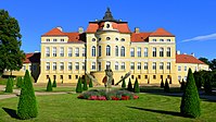
Palace of the Raczyński family in Rogalin, within the Rogalin Landscape Park
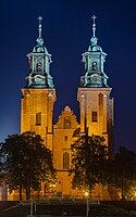
Gniezno cathedral]]
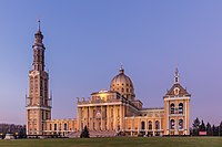
Sanctuary of Saint Joseph in Kalisz


See also[]
References[]
- ^ Od socjaldemokracji do "Solidarności": organizacje robotnicze w Wielkopolsce w XIX i XX wieku, do roku 1990 Edmund Makowski Wydawnictwo Naukowe Uniwersytetu im. Adama Mickiewicza, page 155,1991
- ^ "Kraj Warty" 1934-1945: studium historyczno-gospodarcze okupacji hitlerowskiej Czesław Łuczak Wydawnictwo Poznańskie, 1972
- ^ "Lista miast w Polsce (spis miast, mapa miast, liczba ludności, powierzchnia, wyszukiwarka)". polskawliczbach.pl.
External links[]
- Information on Wielkopolska (Greater Poland) at the University at Buffalo, State University of New York
- Information about Greater Poland
- Database of business, culture, sport, motorization, tourism, and medicine, by CyberWielkopolska
| Authority control: National libraries |
|---|
- Greater Poland
- Historical regions in Poland
- Holocaust locations in Poland