Grenadines Parish
Grenadines | |
|---|---|
Parish | |
 | |
| Coordinates: 13°01′N 061°14′W / 13.017°N 61.233°W | |
| Country | Saint Vincent and the Grenadines |
| Capital City | Port Elizabeth |
| Area | |
| • Total | 17 sq mi (44 km2) |
| Elevation | 999 ft (304 m) |
| Population | |
| • Total | 9,200 |

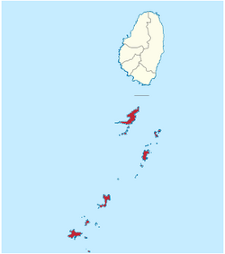
Grenadines is an administrative parish of Saint Vincent and the Grenadines, comprising the islands of the Grenadines other than those belonging to Grenada. The capital is Port Elizabeth.
- Area: 44 km² (17 mi²)
- Population: 9,200 (2000 estimates)
Islands[]
The parish includes the northern Grenadine Islands:[1]
- (12°55′N 061°08′W / 12.917°N 61.133°W)
- Baliceaux (Baliceaux Island, 12°57′N 061°08′W / 12.950°N 61.133°W)
- Battowia (Battowia Island, 12°58′N 061°08′W / 12.967°N 61.133°W)
- Bequia (13°01′N 061°13′W / 13.017°N 61.217°W)
- Canouan (Canouan Island, 12°43′N 061°20′W / 12.717°N 61.333°W)
- (12°40′N 061°24′W / 12.667°N 61.400°W)
- (12°57′N 061°08′W / 12.950°N 61.133°W)
- Dove Cay (12°41′N 061°21′W / 12.683°N 61.350°W)
- (12°41′N 061°21′W / 12.683°N 61.350°W)
- Mayreau (12°39′N 061°23′W / 12.650°N 61.383°W)
- Mustique (12°53′N 061°11′W / 12.883°N 61.183°W)
- Petit Canouan (12°47′N 061°17′W / 12.783°N 61.283°W)
- (12°50′N 061°12′W / 12.833°N 61.200°W)
- Petit Mustique (12°51′N 061°12′W / 12.850°N 61.200°W)
- Petit Nevis (12°58′N 061°15′W / 12.967°N 61.250°W)
- Petit Saint Vincent (12°32′N 061°23′W / 12.533°N 61.383°W)
- (12°57′N 061°17′W / 12.950°N 61.283°W)
- Prune Island (Palm Island, 12°35′N 061°24′W / 12.583°N 61.400°W)
- Quatre (Isle à Quatre, 12°57′N 061°15′W / 12.950°N 61.250°W)
- (12°51′N 061°10′W / 12.850°N 61.167°W)
- (12°36′N 061°25′W / 12.600°N 61.417°W)
- Saint Elairs Cay (12°59′N 061°14′W / 12.983°N 61.233°W)
- (12°36′N 061°26′W / 12.600°N 61.433°W)
- Savan (Savan Island, 12°48′N 061°12′W / 12.800°N 61.200°W)
- (Les Piloris, 12°54′N 061°10′W / 12.900°N 61.167°W)
- Tobago Cays (12°38′N 061°21′W / 12.633°N 61.350°W)
- Union Island (12°36′N 061°26′W / 12.600°N 61.433°W)
Populated places[]
The following populated places are located in the parish of Grenadine:[1]
| Name | Coordinates | Island |
|---|---|---|
| Ashton | 12°35′41″N 061°26′05″W / 12.59472°N 61.43472°W [2] | Union Island |
| 12°57′N 061°15′W / 12.950°N 61.250°W | Quatre | |
| Charlestown | 12°42′03″N 061°19′53″W / 12.70083°N 61.33139°W [3] | Canouan |
| 12°53′N 061°11′W / 12.883°N 61.183°W | Mustique | |
| Clifton | 12°35′45″N 061°25′07″W / 12.59583°N 61.41861°W [4] | Union Island |
| Derrick | 12°59′N 061°15′W / 12.983°N 61.250°W | Bequia |
| 12°53′N 061°11′W / 12.883°N 61.183°W | Mustique | |
| 12°59′32″N 061°14′10″W / 12.99222°N 61.23611°W [5] | Bequia | |
| Lovell Village | 12°52′57″N 061°11′16″W / 12.88250°N 61.18778°W [6] | Mustique |
| 12°38′19″N 061°23′38″W / 12.63861°N 61.39389°W [7] | Mayreau | |
| 12°59′17″N 061°15′11″W / 12.98806°N 61.25306°W [8] | Bequia | |
| Port Elizabeth | 13°00′40″N 061°14′04″W / 13.01111°N 61.23444°W [9] | Bequia |
References[]
- ^ Jump up to: a b "GeoNames Search". National Geospatial-Intelligence Agency. Retrieved 2 March 2013.
- ^ "Ashton". Wikimapia. Retrieved 3 March 2013.
- ^ "Charlestown". Wikimapia. Retrieved 3 March 2013.
- ^ "Clifton". Wikimapia. Retrieved 3 March 2013.
- ^ "Friendship". Wikimapia. Retrieved 3 March 2013.
- ^ "Lovell Village". Wikimapia. Retrieved 3 March 2013.
- ^ "Old Wall". Wikimapia. Retrieved 3 March 2013.
- ^ "Lovell Village". Wikimapia. Retrieved 3 March 2013.
- ^ "Port Elizabeth". Wikimapia. Retrieved 3 March 2013.
This article needs additional citations for verification. (March 2013) |
External links[]
- Parishes of Saint Vincent and the Grenadines, Statoids.com
| Authority control |
|
|---|
This Saint Vincent and the Grenadines location article is a stub. You can help Wikipedia by . |
Categories:
- Parishes of Saint Vincent and the Grenadines
- Saint Vincent and the Grenadines geography stubs