Guanare
This article needs additional citations for verification. (April 2019) |
Guanare | |
|---|---|
City | |
| Guanare | |
     | |
 Flag | |
 Guanare | |
| Coordinates: 9°02′37″N 69°44′56″W / 9.04361°N 69.74889°WCoordinates: 9°02′37″N 69°44′56″W / 9.04361°N 69.74889°W | |
| Country | |
| State | |
| Founded | 3 November 1591 |
| Area | |
| • Total | 2,008 km2 (775 sq mi) |
| Elevation | 183 m (600 ft) |
| Population (2008) | |
| • Total | 235,201 |
| • Density | 100.63/km2 (260.6/sq mi) |
| • Demonym | Guanareño(a) |
| Time zone | UTC−4 (VET) |
| Postal code | 3350 |
| Area code(s) | 0257 |
| Climate | Aw |
| Website | Alcaldía de Guanare (in Spanish) |
| The area and population figures are for the municipality | |

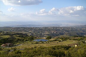
Guanare (Spanish pronunciation: [ɡwaˈnaɾe]) is the capital and most populated city of Portuguesa State, Venezuela. It is where la Virgen de Coromoto is said to have appeared to a Coromoto Indian.
Guanare was founded on 3 November 1591 by João Fernandes de Leão Pacheco (1543–1593), a Portuguese captain from Portimão. Located at the edge of the Southwestern floodplains, near the Andes foothills, Guanare is in a region known for livestock and agricultural production. Guanare is also the location of one of the campuses of UNELLEZ
Notable people[]
- Javier Bertucci, philanthropist and businessman
- Ivian Sarcos, Miss World 2011
- Martín Pérez, baseballer
Climate[]

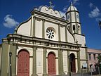
Nuestra Señora de Coromoto National Shrine
| Month | Jan | Feb | Mar | Apr | May | Jun | Jul | Aug | Sep | Oct | Nov | Dec | Year |
|---|---|---|---|---|---|---|---|---|---|---|---|---|---|
| Record high °C (°F) | 37.7 (99.9) |
38.2 (100.8) |
38.5 (101.3) |
37.8 (100.0) |
37.2 (99.0) |
34.3 (93.7) |
34.2 (93.6) |
34.7 (94.5) |
35.2 (95.4) |
34.9 (94.8) |
35.3 (95.5) |
35.9 (96.6) |
38.5 (101.3) |
| Average high °C (°F) | 33.1 (91.6) |
33.9 (93.0) |
34.2 (93.6) |
32.6 (90.7) |
30.9 (87.6) |
30.1 (86.2) |
30.0 (86.0) |
30.6 (87.1) |
31.3 (88.3) |
31.5 (88.7) |
31.8 (89.2) |
32.1 (89.8) |
31.8 (89.2) |
| Daily mean °C (°F) | 26.7 (80.1) |
27.6 (81.7) |
28.4 (83.1) |
27.9 (82.2) |
26.7 (80.1) |
26.0 (78.8) |
25.7 (78.3) |
26.1 (79.0) |
26.6 (79.9) |
26.7 (80.1) |
26.8 (80.2) |
26.3 (79.3) |
26.8 (80.2) |
| Average low °C (°F) | 20.2 (68.4) |
21.2 (70.2) |
22.6 (72.7) |
23.1 (73.6) |
22.5 (72.5) |
21.9 (71.4) |
21.4 (70.5) |
21.5 (70.7) |
21.9 (71.4) |
21.9 (71.4) |
21.7 (71.1) |
20.4 (68.7) |
21.7 (71.1) |
| Record low °C (°F) | 15.4 (59.7) |
15.4 (59.7) |
18.0 (64.4) |
19.4 (66.9) |
19.4 (66.9) |
17.2 (63.0) |
17.9 (64.2) |
17.7 (63.9) |
18.7 (65.7) |
19.0 (66.2) |
17.9 (64.2) |
15.3 (59.5) |
15.3 (59.5) |
| Average rainfall mm (inches) | 14 (0.6) |
17 (0.7) |
41 (1.6) |
131 (5.2) |
227 (8.9) |
245 (9.6) |
266 (10.5) |
200 (7.9) |
173 (6.8) |
172 (6.8) |
111 (4.4) |
33 (1.3) |
1,630 (64.2) |
| Average rainy days (≥ 1.0 mm) | 2.0 | 1.8 | 2.7 | 8.6 | 14.3 | 17.9 | 17.8 | 15.9 | 13.1 | 12.7 | 8.7 | 4.0 | 119.5 |
| Average relative humidity (%) | 67.5 | 64.5 | 64.0 | 69.5 | 76.0 | 78.5 | 78.5 | 78.0 | 77.5 | 76.5 | 76.0 | 72.5 | 73.3 |
| Mean monthly sunshine hours | 257.3 | 221.2 | 207.7 | 141.0 | 145.7 | 138.0 | 167.4 | 186.0 | 195.0 | 207.7 | 219.0 | 232.5 | 2,318.5 |
| Source 1: Instituto Nacional de Meteorología e Hidrología (INAMEH)[1][2] | |||||||||||||
| Source 2: NOAA (extremes, rainy days, and sun)[3] | |||||||||||||
References[]
- ^ "Estadísticos Básicos Temperaturas y Humedades Relativas Máximas y Mínimas Medias" (PDF). INAMEH (in Spanish). Instituto Nacional de Meteorología e Hidrología. Archived from the original (PDF) on 15 June 2013. Retrieved 27 October 2012.
- ^ "Estadísticos Básicos Temperaturas y Humedades Relativas Medias" (PDF). INAMEH (in Spanish). Instituto Nacional de Meteorología e Hidrología. Archived from the original (PDF) on 15 June 2013. Retrieved 27 October 2012.
- ^ "Guanare Climate Normals 1961–1990". National Oceanic and Atmospheric Administration. Retrieved 12 August 2015.
| show Authority control |
|---|
Categories:
- Guanare
- Cities in Portuguesa (state)
- Populated places established in 1591
- 1591 establishments in the Spanish Empire