Guarizama
This article needs additional citations for verification. (May 2012) |
Guarizama | |
|---|---|
Municipality | |
 Guarizama | |
| Coordinates: 14°55′N 86°20′W / 14.917°N 86.333°WCoordinates: 14°55′N 86°20′W / 14.917°N 86.333°W | |
| Country | |
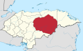
| Department | Olancho |
| Villages | 5 |
| Municipality since | 1901 |
| Area | |
| • Total | 16.91 km2 (6.53 sq mi) |
| Population (2015) | |
| • Total | 7,852 |
| • Density | 460/km2 (1,200/sq mi) |
| Climate | Aw |

Guarizama is a municipality in the Honduran department of Olancho.
Its name comes from Quanhilzamatil, tight amate tree, probably in the place had that tree.[1]
Historical data[]
In the population census of 1887 listed as Manto Village in 1901 was given municipality status.
Villages[]
The municipality has the following five villages: National Institute of Statistics, Honduras. (Census 2001)
- Guarizama
- El Zapotal
- La Carta
- El Rodeo
- Trinidad
References[]
- ^ http://www.ordenamientoterritorial.hn/images/creacion_municipios/olancho/guarizama.pdf[permanent dead link]
Olancho Department | ||
|---|---|---|
Capital: Juticalpa | ||
| Municipalities |
|  |
This Honduras location article is a stub. You can help Wikipedia by . |
Categories:
- Municipalities of the Olancho Department
- Honduras geography stubs