Gueberschwihr
show This article may be expanded with text translated from the corresponding article in French. (July 2014) Click [show] for important translation instructions. |
Gueberschwihr
Gawerschwihr | |
|---|---|
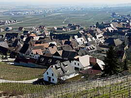 Part of the village of Gueberschwihr seen from the hillside | |
 Coat of arms | |
show Location of Gueberschwihr | |
 Gueberschwihr | |
| Coordinates: 48°00′16″N 7°16′37″E / 48.0044°N 7.2769°ECoordinates: 48°00′16″N 7°16′37″E / 48.0044°N 7.2769°E | |
| Country | France |
| Region | Grand Est |
| Department | Haut-Rhin |
| Arrondissement | Thann-Guebwiller |
| Canton | Wintzenheim |
| Government | |
| • Mayor (2020–2026) | Roland Husser[1] |
| Area 1 | 8.91 km2 (3.44 sq mi) |
| Population (Jan. 2018)[2] | 848 |
| • Density | 95/km2 (250/sq mi) |
| Time zone | UTC+01:00 (CET) |
| • Summer (DST) | UTC+02:00 (CEST) |
| INSEE/Postal code | 68111 /68420 |
| Elevation | 197–873 m (646–2,864 ft) (avg. 260 m or 850 ft) |
| 1 French Land Register data, which excludes lakes, ponds, glaciers > 1 km2 (0.386 sq mi or 247 acres) and river estuaries. | |


Gueberschwihr (Alemannic German: Gawerschwihr; German: Geberschweier) is a commune in the Haut-Rhin department in Grand Est in north-eastern France.
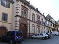
Town hall

Church


See also[]
References[]
- ^ "Répertoire national des élus: les maires". data.gouv.fr, Plateforme ouverte des données publiques françaises (in French). 2 December 2020.
- ^ "Populations légales 2018". INSEE. 28 December 2020.
| Wikimedia Commons has media related to Gueberschwihr. |
| show Authority control |
|---|
This Haut-Rhin geographical article is a stub. You can help Wikipedia by . |
Categories:
- Communes of Haut-Rhin
- Haut-Rhin geography stubs