Habitat/Species Management Area of Cahouane
The topic of this article may not meet Wikipedia's notability guideline for geographic features. (November 2021) |
| Habitat/Species Protected Area of Cahouane | |
|---|---|
IUCN category IV (habitat/species management area) | |
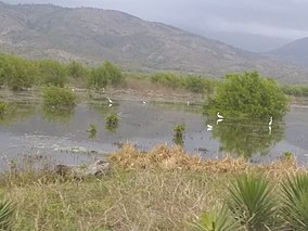 Mangroves and egrets in the Habitat/Species Protected Area of Cahouane (M. Reith) | |
 Location in Haiti | |
| Location | Haiti |
| Nearest city | Tiburon |
| Coordinates | 18°17′00″N 74°19′00″W / 18.28333°N 74.31667°WCoordinates: 18°17′00″N 74°19′00″W / 18.28333°N 74.31667°W |
| Area | 5,940 ha (22.9 sq mi) |
| Established | 2013 |

Habitat/Species Protected Area of Cahouane (French: Aire Protégée Habitat/Especes de la Cahouane) is a mangrove management area located in Southwestern Haiti near the village of between Les Anglais and Tiburon. It was established in 2013. It is 59.4 square kilometres (22.9 sq mi) in size.
After Hurricane Allan in 1980, the lagune had been overused and the mangroves cut down, until the area was nearly destroyed in 2015. The lagune has been reforested, and the mangoves were successfully restored by 2020. Birds and aquatic organisms have returned.[1][2]
Species[]
References[]
- ^ "Environnement : La restauration des mangroves de Cahouane un succès". iciHaïti.com. 27 July 2020. Retrieved 14 November 2021.
{{cite web}}: CS1 maint: url-status (link) - ^ "Mangrove restoration in Haiti moves up a gear". unep.org. 24 July 2020. Retrieved 14 November 2021.
{{cite web}}: CS1 maint: url-status (link)
Categories:
- IUCN Category IV