Mangrove
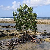
A mangrove is a shrub or small tree that grows in coastal saline or brackish water. The term is also used for tropical coastal vegetation consisting of such species. Mangroves occur worldwide in the tropics and subtropics and even some temperate coastal areas, mainly between latitudes 30° N and 30° S, with the greatest mangrove area within 5° of the equator.[1][2] Mangrove plant families first appeared during the Late Cretaceous to Paleocene epochs, and became widely distributed in part due to the movement of tectonic plates. The oldest known fossils of mangrove palm date to 75 million years ago.[2]
The word "mangrove" is used in at least three senses:
- most broadly to refer to the habitat and entire plant assemblage or mangal,[3] [4][page needed] for which the terms mangrove forest biome and mangrove swamp are also used;
- to refer to all trees and large shrubs in a mangrove swamp; [3]and
- narrowly to refer only to mangrove trees of the genus Rhizophora of the family Rhizophoraceae.[5]
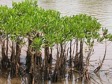
Mangroves are salt-tolerant trees, also called halophytes, and are adapted to live in harsh coastal conditions. They contain a complex salt filtration system and a complex root system to cope with saltwater immersion and wave action. They are adapted to the low-oxygen conditions of waterlogged mud,[6] but are most likely to thrive in the upper half of the intertidal zone.[7]
The mangrove biome, or mangal, is a distinct saline woodland or shrubland habitat characterized by depositional coastal environments, where fine sediments (often with high organic content) collect in areas protected from high-energy wave action. The saline conditions tolerated by various mangrove species range from brackish water, through pure seawater (3 to 4% salinity), to water concentrated by evaporation to over twice the salinity of ocean seawater (up to 9% salinity).[8][9]
Beginning in 2010[10][1] remote sensing technologies and global data have been used to assess areas, conditions and deforestation rates of mangroves around the world.[2] In 2018, the Global Mangrove Watch Initiative released a new global baseline which estimates the total mangrove forest area of the world as of 2010 at 137,600 km2 (53,100 sq mi), spanning 118 countries and territories.[2][10] Mangrove loss continues due to human activity, with a global annual deforestation rate estimated at 0.16%, and per-country rates as high as 0.70%. Degradation in quality of remaining mangroves is also an important concern.[2]
There is interest in mangrove restoration for several reasons. Mangroves support sustainable coastal and marine ecosystems. They protect nearby areas from tsunamis and extreme weather events. Mangrove forests are also effective at carbon sequestration and storage and impede climate change.[2][11][12] The success of mangrove restoration may depend heavily on engagement with local stakeholders, and on careful assessment to ensure that growing conditions will be suitable for the species chosen.[7]
Etymology[]
Etymology of the English term mangrove can only be speculative and is disputed.[13]:1–2 [3] The term may have come to English from the Portuguese mangue or the Spanish mangle.[3] Farther back, it may be traced to South America and Cariban and Arawakan languages[14] such as Taíno.[15] Other possibilities include the Malay language manggi-manggi[3][13] and the Guarani language.[citation needed] The English usage may reflect a corruption via folk etymology of the words mangrow and grove.[14][13][16]
Ecology[]

Mangrove swamps (mangals) are found in tropical and subtropical tidal areas. Areas where mangroves occur include estuaries and marine shorelines.[17]
The intertidal existence to which these trees are adapted represents the major limitation to the number of species able to thrive in their habitat. High tide brings in salt water, and when the tide recedes, solar evaporation of the seawater in the soil leads to further increases in salinity. The return of tide can flush out these soils, bringing them back to salinity levels comparable to that of seawater.[2][7]
At low tide, organisms are also exposed to increases in temperature and reduced moisture before being then cooled and flooded by the tide. Thus, for a plant to survive in this environment, it must tolerate broad ranges of salinity, temperature, and moisture, as well as several other key environmental factors—thus only a select few species make up the mangrove tree community.[7][2]
About 110 species are considered mangroves, in the sense of being trees that grow in such a saline swamp,[17] though only a few are from the mangrove plant genus, Rhizophora. However, a given mangrove swamp typically features only a small number of tree species. It is not uncommon for a mangrove forest in the Caribbean to feature only three or four tree species. For comparison, the tropical rainforest biome contains thousands of tree species, but this is not to say mangrove forests lack diversity. Though the trees themselves are few in species, the ecosystem that these trees create provides a home (habitat) for a great variety of other species, including as many as 174 species of marine megafauna.[18]
Mangrove plants require a number of physiological adaptations to overcome the problems of low environmental oxygen levels, high salinity, and frequent tidal flooding. Each species has its own solutions to these problems; this may be the primary reason why, on some shorelines, mangrove tree species show distinct zonation. Small environmental variations within a mangal may lead to greatly differing methods for coping with the environment. Therefore, the mix of species is partly determined by the tolerances of individual species to physical conditions, such as tidal flooding and salinity, but may also be influenced by other factors, such as crabs preying on plant seedlings.[19]
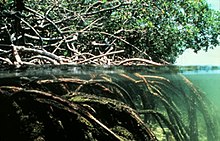
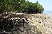
Once established, mangrove roots provide an oyster habitat and slow water flow, thereby enhancing sediment deposition in areas where it is already occurring. The fine, anoxic sediments under mangroves act as sinks for a variety of heavy (trace) metals which colloidal particles in the sediments have concentrated from the water. Mangrove removal disturbs these underlying sediments, often creating problems of trace metal contamination of seawater and organisms of the area.[20]
Mangrove swamps protect coastal areas from erosion, storm surge (especially during tropical cyclones), and tsunamis.[21][22][23] They limit high-energy wave erosion mainly during events such as storm surges and tsunamis.[24] The mangroves' massive root systems are efficient at dissipating wave energy.[25] Likewise, they slow down tidal water enough so that its sediment is deposited as the tide comes in, leaving all except fine particles when the tide ebbs.[26] In this way, mangroves build their environments.[21] Because of the uniqueness of mangrove ecosystems and the protection against erosion they provide, they are often the object of conservation programs,[7] including national biodiversity action plans.[22]
The unique ecosystem found in the intricate mesh of mangrove roots offers a quiet marine habitat for young organisms.[27] In areas where roots are permanently submerged, the organisms they host include algae, barnacles, oysters, sponges, and bryozoans, which all require a hard surface for anchoring while they filter-feed. Shrimps and mud lobsters use the muddy bottoms as their home.[28] Mangrove crabs eat the mangrove leaves, adding nutrients to the mangal mud for other bottom feeders.[29] In at least some cases, the export of carbon fixed in mangroves is important in coastal food webs.[30]
Mangrove plantations in Vietnam, Thailand, Philippines, and India host several commercially important species of fish and crustaceans.[31]
Mangrove forests can decay into peat deposits because of fungal and bacterial processes as well as by the action of termites. It becomes peat in good geochemical, sedimentary, and tectonic conditions.[32] The nature of these deposits depends on the environment and the types of mangroves involved. In Puerto Rico, the red, white, and black mangroves occupy different ecological niches and have slightly different chemical compositions, so the carbon content varies between the species, as well between the different tissues of the plant (e.g., leaf matter versus roots).[32]
In Puerto Rico, there is a clear succession of these three trees from the lower elevations, which are dominated by red mangroves, to farther inland with a higher concentration of white mangroves.[32] Mangrove forests are an important part of the cycling and storage of carbon in tropical coastal ecosystems.[32] Knowing this, scientists seek to reconstruct the environment and investigate changes to the coastal ecosystem over thousands of years using sediment cores.[33] However, an additional complication is the imported marine organic matter that also gets deposited in the sediment due to the tidal flushing of mangrove forests.[32]
Termites play an important role in the formation of peat from mangrove materials.[32] They process fallen leaf litter, root systems and wood from mangroves into peat to build their nests.[32] Termites stabilise the chemistry of this peat and represent approximately 2% of above ground carbon storage in mangroves.[32] As the nests are buried over time this carbon is stored in the sediment and the carbon cycle continues.[32]
Mangroves are an important source of blue carbon. Globally, mangroves stored 4.19 Gt (9.2×10¹² lb) of carbon in 2012.[34] Two percent of global mangrove carbon was lost between 2000 and 2012, equivalent to a maximum potential of 0.316996250 Gt (6.9885710×10¹¹ lb) of CO2 emissions.[34]
Globally, mangroves have been shown to provide measurable economic protections to coastal communities affected by tropical storms.[35]
Biology[]

Of the recognized 110 mangrove species, only about 54 species in 20 genera from 16 families constitute the "true mangroves", species that occur almost exclusively in mangrove habitats.[4] Demonstrating convergent evolution, many of these species found similar solutions to the tropical conditions of variable salinity, tidal range (inundation), anaerobic soils, and intense sunlight. Plant biodiversity is generally low in a given mangrove.[17] The greatest biodiversity of mangroves occurs in Southeast Asia, particularly in the Indonesian archipelago.[36]
Adaptations to low oxygen[]
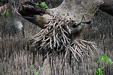
Red mangroves, which can survive in the most inundated areas, prop themselves above the water level with stilt or prop roots and can then absorb air through pores in their bark (lenticels). [37]Black mangroves live on higher ground and make many pneumatophores (specialized root-like structures which stick up out of the soil like straws for breathing).[38][39]
These "breathing tubes" typically reach heights of up to 30 cm (12 in), and in some species, over 3 m (9.8 ft). The four types of pneumatophores are stilt or prop type, snorkel or peg type, knee type, and ribbon or plank type. Knee and ribbon types may be combined with buttress roots at the base of the tree. The roots also contain wide aerenchyma to facilitate transport within the plants.[citation needed]
Nutrient uptake[]
Because the soil is perpetually waterlogged, little free oxygen is available. Anaerobic bacteria liberate nitrogen gas, soluble ferrum (iron), inorganic phosphates, sulfides, and methane, which make the soil much less nutritious.[citation needed] Pneumatophores (aerial roots) allow mangroves to absorb gases directly from the atmosphere, and other nutrients such as iron, from the inhospitable soil. Mangroves store gases directly inside the roots, processing them even when the roots are submerged during high tide.
Limiting salt intake[]
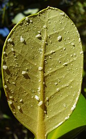
Red mangroves exclude salt by having significantly impermeable roots which are highly suberised (impregnated with suberin), acting as an ultra-filtration mechanism to exclude sodium salts from the rest of the plant. Analysis of water inside mangroves has shown 90% to 97% of salt has been excluded at the roots. In a frequently cited concept that has become known as the "sacrificial leaf", salt which does accumulate in the shoot (sprout) than concentrates in old leaves, which the plant then sheds. However, recent research suggests the older, yellowing leaves have no more measurable salt content than the other, greener leaves.[40] Red mangroves can also store salt in cell vacuoles. White and grey mangroves can secrete salts directly; they have two salt glands at each leaf base (correlating with their name—they are covered in white salt crystals).
Limiting water loss[]
Because of the limited fresh water available in salty intertidal soils, mangroves limit the amount of water they lose through their leaves. They can restrict the opening of their stomata (pores on the leaf surfaces, which exchange carbon dioxide gas and water vapor during photosynthesis). They also vary the orientation of their leaves to avoid the harsh midday sun and so reduce evaporation from the leaves. Anthony Calfo, a noted aquarium author, observed anecdotally that a red mangrove in captivity grows only if its leaves are misted with fresh water several times a week, simulating frequent tropical rainstorms.[41]
Increasing survival of offspring[]
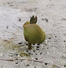
In this harsh environment, mangroves have evolved a special mechanism to help their offspring survive. Mangrove seeds are buoyant and are therefore suited to water dispersal. Unlike most plants, whose seeds germinate in soil, many mangroves (e.g. red mangrove) are viviparous, meaning their seeds germinate while still attached to the parent tree. Once germinated, the seedling grows either within the fruit (e.g. Aegialitis, Avicennia and Aegiceras), or out through the fruit (e.g. Rhizophora, Ceriops, Bruguiera and Nypa) to form a propagule (a ready-to-go seedling) which can produce its own food via photosynthesis.
The mature propagule then drops into the water, which can transport it great distances. Propagules can survive desiccation and remain dormant for over a year before arriving in a suitable environment. Once a propagule is ready to root, its density changes so that the elongated shape now floats vertically rather than horizontally. In this position, it is more likely to lodge in the mud and root. If it does not root, it can alter its density and drift again in search of more favorable conditions.
Taxonomy and evolution[]
The following listing (modified from Tomlinson, 1986) gives the number of species of mangroves in each listed plant genus and family. Mangrove environments in the Eastern Hemisphere harbor six times as many species of trees and shrubs as do mangroves in the New World. Genetic divergence of mangrove lineages from terrestrial relatives, in combination with fossil evidence, suggests mangrove diversity is limited by evolutionary transition into the stressful marine environment, and the number of mangrove lineages has increased steadily over the Tertiary with little global extinction.[42]
Major components[]
| Family | Genus, number of species | Common name |
|---|---|---|
| Acanthaceae, Avicenniaceae, or Verbenaceae (family allocation disputed) |
Avicennia, 9 | Black mangrove |
| Combretaceae | Conocarpus, 1; Laguncularia, 1; Lumnitzera, 3 | Buttonwood, white mangrove |
| Arecaceae | Nypa, 1 (N. fruticans) | Mangrove palm |
| Rhizophoraceae | Bruguiera, 7; Ceriops, 5; Kandelia, 2; Rhizophora, 8 | Red mangrove |
| Lythraceae | Sonneratia, 5 | Mangrove apple |
Minor components[]
| Family | Genus, number of species |
|---|---|
| Acanthaceae | Acanthus, 2 (A. ebracteatus, A. ilicifolius); Bravaisia, 2 (B. berlandieriana, B. integerrima) |
| Arecaceae | Phoenix, 1 (P. paludosa) |
| Cyperaceae | Fimbristylis, 1 |
| Euphorbiaceae | Excoecaria, 2 |
| Lecythidaceae | Barringtonia, 6 |
| Lythraceae | Pemphis, 2 |
| Malvaceae | Camptostemon, 2 (C. philippinensis, C. schultzii); Heritiera, 3 (H. fomes, H. globosa, H. littoralis) |
| Meliaceae | Xylocarpus, 2 (X. granatum, X. moluccensis) |
| Myrtaceae | Osbornia, 1 (O. octodonta) |
| Pellicieraceae | Pelliciera, 1 (P. rhizophorae) |
| Plumbaginaceae | Aegialitis, 2 (A. annulata, A. rotundifolia) |
| Primulaceae | Aegiceras, 2 (A. corniculatum, A. floridum) |
| Pteridaceae | Acrostichum, 3 (A. aureum, A. danaeifolium, A. speciosum) |
| Rubiaceae | Scyphiphora, 1 (S. hydrophyllacea) |
Geographical regions[]
Mangroves can be found in over one hundred countries and territories in the tropical and subtropical regions of the world. The largest percentage of mangroves is found between the 5° N and 5° S latitudes. Approximately 75% of world's mangroves are found in just 15 countries.[1] Estimates of mangrove area based on remote sensing and global data tend to be lower than estimates based on literature and surveys for comparable periods.[2]
In 2018, the Global Mangrove Watch Initiative released a global baseline based on remote sensing and global data for 2010. They estimated the total mangrove forest area of the world as of 2010 at 137,600 km2 (53,100 sq mi), spanning 118 countries and territories.[2][10] Following the conventions for identifying geographic regions from the Ramsar Convention on Wetlands, researchers also reported that Asia has the largest share (38.7%) of the world's mangroves, followed by Latin America and the Caribbean (20.3%) Africa (20.0%), Oceania (11.9%), and Northern America (8.4%).[10]
Top 20 mangrove habitat countries[]

| Rank | Country | Tree cover (km2) in mangrove forests |
Tree cover (km2) in mangrove biome |
|---|---|---|---|
| 1 | 23,143 | 42,278 | |
| 2 | 7,663 | 17,287 | |
| 3 | 4,691 | 7,616 | |
| 4 | 4,169 | 6,236 | |
| 5 | 3,315 | 3,314 | |
| 6 | 2,985 | 6,036 | |
| 7 | 2,653 | 6,908 | |
| 8 | 2,508 | 3,783 | |
| 9 | 2,401 | 7,516 | |
| 10 | 2,060 | 2,084 | |
| 11 | 1,876 | 3,936 | |
| 12 | 1,773 | 2,314 | |
| 13 | 1,672 | 6,236 | |
| 14 | 1,624 | 2,407 | |
| 15 | 1,553 | 1,554 | |
| 16 | 1,323 | 2,673 | |
| 17 | 1,223 | 2,658 | |
| 18 | 1,113 | 1,323 | |
| 19 | 1,081 | 3,864 | |
| 20 | 935 | 1,906 |
Africa[]
There are important mangrove swamps in Kenya, Tanzania, the Democratic Republic of the Congo (DRC), and Madagascar, with swamps in the latter even admixing at the coastal verge with dry deciduous forests.
Nigeria has Africa's largest mangrove coverage, spanning 36,000 km2 (14,000 sq mi). Oil spills and leaks have destroyed much of this in the last 50 years, damaging the local fishing economy and water quality.[45]
Along the coast of the Red Sea, both on the Egyptian side and in the Gulf of Aqaba, mangroves composed primarily of Avicennia marina and Rhizophora mucronata[46] grow in about 28 stands that cover about 5.25 km2 (2.0 sq mi).[47] Almost all Egyptian mangrove stands are now protected.[48]
There are mangroves off the east coast of South Africa extending as far south as the Tylomnqa River (33°13′26.1″N 27°34′50.2″E / 33.223917°N 27.580611°E). Some mangrove stands exist in the St Lucia estuary within iSimangaliso Wetland Park.[49]
 WikiMiniAtlas
North America[]
Central America and the Caribbean[]

Mangroves occur on the Pacific and Caribbean coasts of Belize, Costa Rica, El Salvador, Guatemala, Honduras, Nicaragua, and Panama. Mangroves can also be found in many of the Antilles including Puerto Rico,[50] Cuba, and Hispaniola,[51] as well as other islands in the West Indies such as the Bahamas.
Belize[]
The nation of Belize has the highest overall percentage of forest cover of any of the Central American countries.[52] Belize's mangrove cover assumes the form not only of mangrove forest, but also of scrubs, savannas, and other vegetation types.[53] A 2010 satellite-based study of Belize's mangroves by the World Wildlife Fund (WWF) and the Water Center for the Humid Tropics of Latin America and the Caribbean found, in 2010, that mangroves covered roughly 746.84 km2 (288.36 sq mi), or 3.4% of Belize's territory.[54]
In 1980, by contrast, mangrove cover stood at 762.5 km2 (294.4 sq mi) — also 3.4% of Belize's territory, although, based on the work of mangrove researcher Simon Zisman,[55] Belize's mangrove cover in 1980 was estimated to represent 98.7% of the precolonial extent of those ecosystems. Belize's mangrove cover in 2010 was thus estimated to represent 96.7% of the precolonial cover.[54] Assessing changes in Belize's mangrove cover over a 30-year period was possible because of Belize's participation in the Regional Visualization and Monitoring System, a regional observatory jointly implemented by CATHALAC, RCMRD, ICIMOD, NASA, USAID, and other partners.[56]
Continental United States[]
Red and white mangrove communities are confined to Florida south of 29°N (see Florida mangroves). Black mangroves can be found up to 30°N on the east coast of Florida, and in isolated sections of the wider Gulf Coast, including Texas.[57]
The trimming of mangroves in Florida is regulated, and altering a mangrove without a permit (e.g., removing or cutting the plant so much that it dies or is defoliated) is prohibited and carries a fine.[58]
Mexico[]
In Mexico, four species of mangrove predominate: Rhizophora mangle, Laguncularia racemosa, Avicennia germinans, and Conocarpus erectus.[59] During an inventory conducted by CONABIO between 2006 and 2008, 7,700.57 km2 (2,973.21 sq mi) of mangrove were counted.[60] Of this total, 55% are located in the Yucatán Peninsula.[60]
Significant mangals include the Marismas Nacionales-San Blas mangroves found in Sinaloa and Nayarit.[citation needed]
South America[]
Brazil contains approximately 26,000 km2 (10,000 sq mi) of mangrove forests, or 15% of the world's total.[citation needed]

Ecuador has substantial remaining mangrove forests in the provinces of El Oro, Guayas, Manabi, and Esmeraldas, with limited forest remaining in Santa Elena.[61] The northern portion of Esmeraldas province has a large pristine mangrove forest that is preserved as the Reserva Ecológica Cayapas-Mataje (REMACAN) and is an original Ramsar site.[62] This forest is the most preserved within Ecuador and likely the most pristine forest along the Pacific Coast of the Americas.[63]

The only other major mangrove holding in Esmeraldas is in-and-around the community of Muisne and the Rio Muisne Estuary Swampland Wildlife Refuges.[65] The mangroves in-and-around the estuaries of Muisne have decreased in area from 32.22 to 10.65 km2 (12.44 to 4.11 sq mi) from the period between 1971 to 2005. During this time, commercial shrimp aquaculture has become the dominant land-cover within this estuary environment.[66][relevant?]
On the border of Esmeraldas province and Manabí province is a formerly large area of mangrove within Cojimies Estuary. The mangroves in this estuary are some of the most degraded in Ecuador with only 19% of 1971 mangrove area remaining as of 1998, although mangrove has recovered since this date.[63] Within Manabí the major mangrove holding estuary is the Chone estuary situated near the city of Bahía de Caráquez. Again, Chone has undergone substantial mangrove deforestation since the advent of commercial aquaculture in Ecuador.[66] However, mangrove loss appears to have halted in this estuary and mangrove regrowth driven by local fisherman is now occurring.[67]
Peru has two small regions of mangrove located in the Department of Tumbes, north-west of the country on the Ecuadorian Border, and also in the Piura region, where the "Manglares de Vice" in the Sechura Province of Piura is the southernmost region of the Pacific to hold mangroves.[1]
Venezuela's northern Caribbean island, Margarita, possesses mangrove forests in the Parque nacional Laguna de La Restinga. Venezuela has 4% of the world's mangroves, with an extension of 6,735 km2 (2,600 sq mi).[68]
Colombia possesses large mangrove forests on both its Caribbean and Pacific coasts.
The Mangrove forests of Suriname have a height of 20–25 m (66–82 ft) and are found mainly in the coastal area. There are six types of mangroves, namely two types of Avicennia germinans (parwa or black mangroves), three types of Rhizophora mangle (mangro or red mangroves) and a small mangrove species Laguncularia racemosa (akira or tjila, white mangrove).[69][70]
Asia[]
Mangroves occur on Asia's south coast, throughout the Indian subcontinent, in all Southeast Asian countries, and on islands in the Indian Ocean, Persian Gulf, Arabian Sea, Bay of Bengal, South China Sea, East China Sea and the Pacific. The mangal is particularly prevalent in the deltas of large Asian rivers.
Indonesia[]
In the Indonesian Archipelago, mangroves occur around much of Papua province, Sumatra, Borneo, Sulawesi, Maluku and the surrounding islands. Indonesia has around 93,600 km2 (36,100 sq mi) of mangrove forests, but 48% is categorized as 'moderately damaged' and 23% as 'badly damaged'.[71]
Japan[]
The most extensive mangrove forests of the Ryukyu Islands in East China Sea occur on Iriomote Island of the Yaeyama Islands, Okinawa, Japan.[72] Seven types of mangroves are recognised on Iriomote Island.[73]
The northern limit of mangrove forests in the Indomalaya Ecozone is considered to be Tanegashima Island, Kyushu, Japan.[74]
Malaysia[]
On the Malay Peninsula, mangroves cover an estimated 1,089.7 km2 (420.7 sq mi), while most of the remaining 5,320 km2 (2,054 sq mi) mangroves in Malaysia are on the island of Borneo.[75]
Philippines[]

The Philippines, with the fifth longest coastline in the world, holds at least 50% of known mangrove species and is considered one of the top 15 most mangrove-rich countries. Philippine mangrove forests cover an estimated 2,473.62 km2 (955.07 sq mi) of coastline as of 2003, which comprise 3% of the total forest cover remaining in the country. The island with the largest mangrove cover is Mindanao, with 29% of the national total. Mindanao and Palawan also have the largest pristine old-growth mangrove forests (at 45.82 km2 (17.69 sq mi) and 53.17 km2 (20.53 sq mi), respectively). The islands suffering from the most extensive mangrove deforestation are Luzon and Mindoro.[76][77]

The provinces with the highest mangrove coverage are Palawan (22.2%), Sulu (8%), Zamboanga del Norte and Zamboanga del Sur (9.86%), Surigao del Norte and Surigao del Sur (6.8%), Eastern Samar and Western Samar (6.1%), Quezon (5.5%), Tawi-Tawi (4.4%), Bohol (3.69%), and Basilan (2.97%).[76]
19% of the total mangrove area are within protected areas. These protected areas include the Northern Sierra Madre Natural Park (eastern Luzon), Bakhawan Eco-Park (Panay), Malampaya Sound Protected Landscape and Seascape (northwestern Palawan), (northwestern Palawan), Rasa Island Wildlife Sanctuary (central Palawan), Siargao Island Protected Landscape and Seascape (Siargao), Tañon Strait Protected Seascape (Negros and Cebu), Biri Larosa Protected Landscape and Seascape (northern Samar), Dumanquilas Bay Protected Landscape and Seascape (western Mindanao), Mt. Guiting-Guiting Natural Park (Sibuyan Island, Romblon), and the Calauit Safari Park (Calauit Island, Calamian Islands).[76][78]

In the 1920s, the Philippines had a mangrove cover estimated at between 4,000 km2 (1,500 sq mi) to 5,000 km2 (1,900 sq mi). It dropped to a low of 1,600 km2 (620 sq mi) by 1994. The leading cause for mangrove deforestation in the Philippines is the commercial development of the areas for aquaculture. Between 1968 and 1983, 2,370 km2 (920 sq mi) of mangrove forest were lost to the creation of cultured ponds for farming fish, shrimp, and other aquatic resources. Urbanization is also the main cause of the loss of the formerly extensive mangrove forests in the Manila Bay.[78][79][80]

Due to conservation measures it rose back to the current level by 2003 and mangrove populations are considered "relatively stable" by the World Bank. Several mangrove conservation and reforestation efforts have been completed. Some of the early ones failed due to the use of the wrong species for the wrong habitats and pests damaging monoculture reforestation sites. More successful reforestation efforts have identified that a key factor was community involvement and the education of local villages of the importance of mangrove forests to maintaining fish stocks, providing a natural barrier to typhoons and tsunamis, and providing habitats for migratory birds. Mangrove-friendly aquaculture technology is also disseminated by the government via training by the Bureau of Fisheries and Aquatic Resources (BFAR). Another recent approach is the promotion of mangrove forest ecotourism.[76][78][79][81]
In line with mangrove promotion, development, and rehabilitation efforts in coastal areas, species diversity and the degree of impact of natural and anthropogenic activities on mangroves in nine coastal barangays of Mulanay, Quezon, Philippines were assessed. Results revealed that all nine barangays had low species diversity index.[82] Taxonomic identification revealed eleven mangrove species - Avicennia marina, Avicennia rumphiana, Bruguiera gymnorrhiza, Ceriops decandra, Ceriops tagal, Excoecaria agallocha, Rhizophora apiculata, Rhizophora mucronata, Sonneratia alba, Xylocarpus granatum, and Xylocarpus moluccensis belonging to five families.[82] Impact analysis revealed that Patabog registered moderate impact, San Isidro and Canuyep with high impact, and Sta. Rosa, Sto. Niño, Buntayog, Amuguis and Ibabang Yuni were greatly affected by combined natural disturbances and anthropogenic activities.[82]
In 1991, the cutting and harvesting of all mangrove species was banned under Republic Act 7161. The conversion of mangrove forest areas for fishpond development was also banned under Republic Act 8550 (the Philippine Fisheries Code of 1998).[81] Enforcement of these laws remain problematic. The ban also affects small communities which previously partnered with the government to grow and harvest mangrove forests for timber, firewood, and other purposes.[83][84][85]
Taiwan[]

The three most important[why?] mangrove forests of Taiwan are: Tamsui River in New Taipei, (zh) in Miaoli County and the Sicao Wetlands in Tainan.[86] Four types of mangrove exist in Taiwan.[87] Some places have been developed as scenic areas, such as the log raft routes in Sihcao.[citation needed]
Vietnam[]

In Vietnam, mangrove forests grow along the southern coast, including two forests: the Cần Giờ Mangrove Forest biosphere reserve and the U Minh mangrove forest in the sea and coastal region of Kiên Giang, Cà Mau and Bạc Liêu provinces. The mangrove forests of the Bay of Kompong Som (maki) in Cambodia are of major ecological and cultural importance, as the human population relies heavily on the crabs and fish that live in the roots.[88][verification needed]
Middle East[]
Arabian Peninsula[]
The wide and shallow shelf on Yemen's Red Sea coast consists of unconsolidated sediments, which support 11 species of seagrasses up to 500 m (1,600 ft) offshore on the shoreward side of sand spits, islands and reefs. Fragmented mangrove patches cover around 30–50 km2 (12–19 sq mi) along the coast (100–200 m (330–660 ft) wide along a 122 km (76 mi) stretch). The mangrove forest of Kamaran island was logged in the early 20th century, and the timber used for construction in Aden.[89]
The mangrove forests along the shoreline of the United Arab Emirates are an integral part of its coastal ecosystem. The Environment Agency – Abu Dhabi (EAD) is currently working on rehabilitation, conservation and protection of mangrove forests in seven key sites in Abu Dhabi including: Saadiyat Island, Jubail Island, Marawah Marine Biosphere Reserve (which also comprises Bu Tinah Island), Bu Sayeef Protected Area, Ras Gharab, the Eastern Corniche[90] and Ras Ghanada.[citation needed]
Oman supports large areas of mangroves near Muscat, in particular at Shinas, Qurm Park and Mahout Island. In Arabic, mangrove trees are known as qurm (قُرْم), thus the mangrove area in Oman is known as Qurm Park. A small mangrove area is present in the Kingdom of Bahrain.[91]
Iran[]
Mangrove forests are present in Iran between 25°11′N to 27°52′N, in the northern parts of the Persian Gulf and Sea of Oman. Pockets of the biome extend (from southwest to southeast) along the shores of the maritime provinces Bushehr, Hormozgan, and Sistan and Balouchestan. Forests on and near the island of Qeshm in the Persian Gulf are dominated by the species Avicennia marina, known locally as the "hara" or "harra" tree, and cover an area of approximately 20 km2 (7.7 sq mi). This area is protected as the UNESCO Hara Biosphere Reserve, where commercial use is restricted to fishing (mainly shrimp), tourist boat trips, and limited mangrove cutting for animal feed.[citation needed]
South Asia[]
India[]

As per the ISFR 2017 report, the total area of mangrove cover of India is 4,921 km2 (1,900 sq mi), (181 km2 (70 sq mi) positively changed with respect to 2015 mangrove cover assessment) which contributes 3.3% to the global mangrove cover.[92] The deltas of the Ganges, Mahanadi, Krishna, Godavari, and Kaveri rivers contain mangrove forests. Backwaters in Kerala have high density of mangrove forest on the shores.[93] Indian mangroves consist of 46 species (4 of which are natural hybrids) belonging to 22 genera and 14 families, representing about 57% of the world's mangrove species.[94]
The following table shows the prevalence of mangroves in the states of India and the total area covered by them in square kilometers.[95]
| Rank | States/UTs with highest mangrove cover in 2017 | Total mangrove cover in km2 in 2015[96] | 2017 [96][92] |
|---|---|---|---|
| 1 | West Bengal | 2,106 | 2114 |
| 2 | Gujarat | 1,107 | 1140 |
| 3 | Andaman And Nicobar Islands | 617 | 617 |
| 4 | Andhra Pradesh | 367 | 404 |
| 5 | Maharashtra | 222 | 304 |
| 6 | Odisha | 231 | 243 |
| 7 | Tamil Nadu | 47 | 49 |
| 8 | Goa | 26 | 26 |
| 9 | Kerala | 9 | 9 |
| 10 | Karnataka | 3 | 10 |
The Pichavaram mangroves in Tamil Nadu is India's one of the largest mangrove forests.[citation needed] The Bhitarkanika Mangroves Forest of Odisha, by the Bay of Bengal, is India's second largest mangrove forest.[97][98] Other major mangals occur on the Andaman and Nicobar Islands and the Gulf of Kutch in Gujarat.[99]
Baratang Island[]
The Baratang Island mangroves are located within the Andaman and Nicobar Islands. The mangrove swamps of Baratang Island are situated between Middle and South Andaman Island.[100]
Bhitarkanika[]

The Bhitarkanika mangroves form India's second largest forest, located in the state of Odisha. Bhitarkanika is created by the two river deltas of Brahmani and Baitarani river and one of the important Ramsar Wetland in India. It is also the home of saltwater crocodiles and nesting olive ridley sea turtles.[101][100]
Godavari-Krishna[]
The Godavari-Krishna mangroves lie in the delta of the Godavari and Krishna rivers in the state of Andhra Pradesh. Mangroves ecoregion is under protection for Calimere Wildlife and Pulicat Lake Bird Sanctuary.[100]
Mumbai[]
The megacity Mumbai has mangroves on its coastline along the west coast of India. A total of 10 mangrove species were reported in this area, dominated by Avicennia marina.[102] These mangroves support a rich diversity of life forms, especially molluscs.[103] The mangrove area in Mumbai City District is 2 km2, and in Mumbai Suburban District is 64 km2.[104] Mumbai's single largest mangrove belt is the western bank of Thane Creek. The Government of Maharashtra has declared much of the area on the western bank of Thane Creek as the Thane Creek Flamingo Sanctuary.[105] Mangrove areas on the government lands are governed by the Maharashtra Forest Department. An extensive area of mangroves on the private lands in Vikhroli has been conserved by Soonabai Pirojsha Godrej Marine Ecology Centre, Vikhroli, Mumbai.[106]
Pichavaram[]

The Pichavaram mangroves are situated at Pichavaram near Chidambaram in the state of Tamil Nadu. Pichavaram ranks amongst one of the most exquisite scenic spots in Tamil Nadu and has many species of aquatic birds.[100]
Sundarbans[]

The Sundarbans in the Ganges-Brahmaputra delta extend from the Hooghly River in West Bengal to the Baleswar River in Bangladesh, covering an area of about 10,000 km2 (3,900 sq mi). This area comprises closed and open mangrove forests, agriculturally used land, mudflats and barren land. It is intersected by tidal streams and channels. Four protected areas in the Sundarbans, viz Sundarbans National Park, Sundarbans West, Sundarbans South and Sundarbans East Wildlife Sanctuaries are enlisted as UNESCO World Heritage Sites. Biodiversity includes at least 27 mangrove species, 40 mammal, 35 reptile and 260 bird species. More than 2.5 million people are estimated to live in the vicinity of the Sundarbans, making them one of the world's most densely populated areas.[107]
It is the largest mangrove region and the largest single block of tidal halophytic mangrove forest in the world. Sundri (Heritiera fomes) trees provide durable hard timber. Palm, coconut, keora, agar, also grow in some parts of the delta. India's mangrove forests are habitat for saltwater crocodile (Crocodylus porosus), turtles, and snakes. This region is part of the Great Sundarbans and covers a National Park, Tiger reserve and a Biosphere Reserve.[101]
Sundarbans was designated a Ramsar site on May 21, 1992. The fertile soils of the delta have been subject to intensive human use for centuries, and the ecoregion has been mostly converted to intensive agriculture, with few enclaves of forest remaining. The remaining forests, together with the Sundarbans mangroves, are important habitat for the endangered tiger. Additionally, the Sundarbans serves a crucial function as a protective flood barrier for the millions of inhabitants in and around Kolkata against the result of cyclone activity. Sundarbans is home to many different species of birds, mammals, insects, reptiles and fish. It is estimated that there may be found more than 120 species of fish and over 260 species of birds and more than fifty species of reptiles and eight amphibians.
Maldives[]
Mangroves occur in certain muddy swampy islands of Maldives.[108]
Pakistan[]


Pakistani mangroves are located mainly along the delta of the Indus River (the Indus River Delta-Arabian Sea mangroves ecoregion). Major mangrove forests are found on the coastline of the provinces of Sindh and Balochistan.
In Karachi, land reclamation projects have led to the cutting down of mangrove forests for commercial and urban development. On 22 June 2013, Sindh Forest Department, Govt. of Sindh, Pakistan, with the help of 300 local coastal volunteer planters set the Guinness World Record by planting 847,250 mangrove saplings at Kharo Chan, Thatta, Sindh, Pakistan in a little over 12 hours. This is the highest number of saplings planted within a day under the Guinness World Record category of "Maximum Number of Trees Planted in a Day".
Sindh Forest Department, Government of Sindh Mangrove has played pioneer role for the conservation and protection of the mangroves in the Indus Delta since late 1950s when it was handed over the areas. A breakthrough success is the re-introduction of Rhizophora mucronata into the Indus Delta, which had become extinct there. More recently, a threatened mangrove shrub, Ceriops tagal, has also been successfully re-introduced. A third species, Aegiceras corniculatum, is under trials at the nursery stage.
A major initiative is currently underway in Sindh to rehabilitate degraded mangrove mudflats. Since 2010 alone, around 550 km2 (210 sq mi) of former mangrove forest have been planted and rehabilitated. During this period, through concerted efforts and a rigorous conservation policy adopted by the Sindh Forest Department, the government of Sindh and the federal government, a mangrove resource base of around 1,500 km2 (580 sq mi) has been created, with the support of local coastal communities. International organizations like IUCN and WWF are also playing critical role to support this initiative. Other achievements include: (1) Declaring all the mangrove forests in the Indus Delta as Protected Forests in December 2010; Constitution of a Mangrove Conservation Committee at the provincial level which includes all stakeholders as members and overall awareness of the importance of mangroves and its ecosystem.[109]
Oceania[]
Australia and New Guinea[]

Australia and Papua New Guinea both rank in the top five mangrove holding nations globally.[110] More than five species of Rhizophoraceae grow in Australasia,[111] with particularly high biodiversity on the island of New Guinea and northern Australia.[111]
As of 2012, Australia has slightly below 10,000 km2 (3,900 sq mi) of mangroves[110] and Papua New Guinea has just under approximately 5,000 km2 (1,900 sq mi) ±12% (CI 0.9, n = 7) of mangrove.[110]
New Zealand[]
New Zealand also has mangrove forests extending to around 38°S (similar to Australia's latitudinal limit): the southernmost examples are at Raglan Harbour (37°48′S) on the west coast and Ohiwa Harbour (near Ōpōtiki, 38°00′S) on the east coast.[citation needed] Avicennia marina australasica is the only mangrove in New Zealand.
Pacific Islands[]
Twenty-five species of mangrove are found on various Pacific islands, with extensive mangrove forests on some. Mangroves on Guam, Palau, Kosrae and Yap have been badly affected by development.[112]
Mangroves are not native to Hawaii, but the red and oriental mangroves have been introduced and are now naturalized.[113] Both species are considered invasive and classified as pests by the University of Hawaii Botany Department.[114]
Exploitation and conservation[]

Adequate data is only available for about half of the global area of mangroves. However, of those areas for which data has been collected, it appears that 35% of the mangroves have been destroyed.[115] Since the 1980s, around 2% of mangrove area is estimates to be lost each year.[116] Assessments of global variation in mangrove loss indicates that national regulatory quality mediates how different drivers and pressures influence loss rates.[117]
The United Nations Environment Programme and Hamilton (2013), estimate that shrimp farming causes approximately a quarter of the destruction of mangrove forests.[118][119] Likewise, the 2010 update of the World Mangrove Atlas indicated that approximately one fifth of the world's mangrove ecosystems have been lost since 1980,[120] although this rapid loss rate appears to have decreased since 2000 with global losses estimated at between 0.16% and 0.39% annually between 2000 and 2012.[44] Despite global loss rates decreasing since 2000, Southeast Asia remains an area of concern with loss rates between 3.58% and 8.08% between 2000 and 2012.[44]
By far the most damaging form of shrimp farming is when a closed ponds system (non-integrated multi-trophic aquaculture) is used (as these require destruction of a large part of the mangrove, and use antibiotics and disinfectants to suppress diseases that occur in this system, and which may also leak into the surrounding environment). Far less damage occurs when integrated mangrove-shrimp aquaculture is used (as this is connected to the sea and subjected to the tides, and less diseases occur, and as far less mangrove is destroyed for it).[121]
Grassroots efforts to protect mangroves from development and from citizens cutting down the mangroves for charcoal production,[122][123] cooking, heating and as a building material are becoming more popular. Solar cookers are distributed by many ngos as a low-cost alternative to wood and charcoal stoves. These may help in reducing the demand for charcoal.
- In Thailand, community management has been effective in restoring damaged mangroves.[124] Also, production of mangrove honey is practiced, as a way to generate sustainable income for nearby people, keeping them from destroying the mangrove and generate but a short-term revenue.[125][126]
- In Madagascar, honey too is produced in mangroves as a source of (non-destructive) income generation. In addition, silk pods from endemic silkworm species are also collected in the Madagascar mangroves for wild silk production.[127][123]
- In the Bahamas, for example, active efforts to save mangroves are occurring on the islands of Bimini and Great Guana Cay.
- In Trinidad and Tobago as well, efforts are underway to protect a mangrove threatened by the construction of a steel mill and a port.[citation needed]
- Within northern Ecuador mangrove regrowth is reported in almost all estuaries and stems primarily from local actors responding to earlier periods of deforestation in the Esmeraldas region.[67]
Mangroves have been reported to be able to help buffer against tsunami, cyclones, and other storms, and as such may be considered a flagship system for ecosystem-based adaptation to the impacts of climate change. One village in Tamil Nadu was protected from tsunami destruction—the villagers in Naluvedapathy planted 80,244 saplings to get into the Guinness Book of World Records. This created a kilometre-wide belt of trees of various varieties. When the 2004 tsunami struck, much of the land around the village was flooded, but the village itself suffered minimal damage.[128]

Ocean deoxygenation[]
Compared to seagrass meadows and coral reefs, hypoxia is more common on a regular basis in mangrove ecosystems, through ocean deoxygenation is compounding the negative effects by anthropogenic nutrient inputs and land use modification.[129]
Like seagrass, mangrove trees transport oxygen to roots of rhizomes, reduce sulfide concentrations, and alter microbial communities. Dissolved oxygen is more readily consumed in the interior of the mangrove forest. Anthropogenic inputs may push the limits of survival in many mangrove microhabitats. For example, shrimp ponds constructed in mangrove forests are considered the greatest anthropogenic threat to mangrove ecosystems. These shrimp ponds reduce estuary circulation and water quality which leads to the promotion of diel-cycling hypoxia. When the quality of the water degrades, the shrimp ponds are quickly abandoned leaving massive amounts of wastewater. This is a major source of water pollution that promotes ocean deoxygenation in the adjacent habitats.[129][130]
Due to these frequent hypoxic conditions, the water does not provide habitats to fish. When exposed to extreme hypoxia, ecosystem function can completely collapse. Extreme deoxygenation will affect the local fish populations, which are an essential food source. The environmental costs of shrimp farms in the mangrove forests grossly outweigh the economic benefits of them. Cessation of shrimp production and restoration of these areas reduce eutrophication and anthropogenic hypoxia.[129]
Reforestation[]

In some areas, mangrove reforestation and mangrove restoration is also underway. Red mangroves are the most common choice for cultivation, used particularly in marine aquariums in a sump to reduce nitrates and other nutrients in the water. Mangroves also appear in home aquariums, and as ornamental plants, such as in Japan.[citation needed]
In Senegal, Haïdar El Ali has started the fr project, which (amongst others) focuses on reforesting several areas with mangroves.[131]
The Manzanar Mangrove Initiative is an ongoing experiment in Arkiko, Eritrea, part of the Manzanar Project founded by Gordon H. Sato, establishing new mangrove plantations on the coastal mudflats. Initial plantings failed, but observation of the areas where mangroves did survive by themselves led to the conclusion that nutrients in water flow from inland were important to the health of the mangroves. Trials with the Eritrean Ministry of Fisheries followed, and a planting system was designed to provide the nitrogen, phosphorus, and iron missing from seawater.[132][133]
The propagules are planted inside a reused galvanized steel can with the bottom knocked out; a small piece of iron and a pierced plastic bag with fertilizer containing nitrogen and phosphorus are buried with the propagule. As of 2007, after six years of planting, 700,000 mangroves are growing; providing stock feed for sheep and habitat for oysters, crabs, other bivalves, and fish.[132][133]
Another method of restoring mangroves is by using quadcopters (which are able to carry and deposit seed pods). According to Irina Fedorenko, an amount of work equivalent to weeks of planting using traditional methods can be done by a drone in days, and at a fraction of the cost.[134]
Seventy percent of mangrove forests have been lost in Java, Indonesia. Mangroves formerly protected the island's coastal land from flooding and erosion.[135] Wetlands International, an NGC based in the Netherlands, in collaboration with nine villages in Demak where lands and homes had been flooded, began reviving mangrove forests in Java. Wetlands International introduced the idea of developing tropical versions of techniques traditionally used by the Dutch to catch sediment in North Sea coastal salt marshes.[135] Originally, the villagers constructed a sea barrier by hammering two rows of vertical bamboo poles into the seabed and filling the gaps with brushwood held in place with netting. Later the bamboo was replaced by PVC pipes filled with concrete. As sediment gets deposited around the brushwood, it serves to catch floating mangrove seeds and provide them with a stable base to germinate, take root and regrow. This creates a green belt of protection around the islands. As the mangroves mature, more sediment is held in the catchment area; the process is repeated until a mangrove forest has been restored. Eventually the protective structures will not be needed.[135] By late 2018, 16 km (9.9 mi) of brushwood barriers along the coastline had been completed.[135]
A concern over reforestation is that although it supports increases in mangrove area it may actually result in a decrease in global mangrove functionality and poor restoration processes may result in longer term depletion of the mangrove resource.[136]
National studies[]
In terms of local and national studies of mangrove loss, the case of Belize's mangroves is illustrative in its contrast to the global picture. A recent, satellite-based study[54]—funded by the World Wildlife Fund and conducted by the Water Center for the Humid Tropics of Latin America and the Caribbean (CATHALAC)—indicates Belize's mangrove cover declined by a mere 2% over a 30-year period. The study was born out of the need to verify the popular conception that mangrove clearing in Belize was rampant.[137]
Instead, the assessment showed, between 1980 and 2010, under 16 km2 (6.2 sq mi) of mangroves had been cleared, although clearing of mangroves near Belize's main coastal settlements (e.g. Belize City and San Pedro) was relatively high. The rate of loss of Belize's mangroves—at 0.07% per year between 1980 and 2010—was much lower than Belize's overall rate of forest clearing (0.6% per year in the same period).[138] These findings can also be interpreted to indicate Belize's mangrove regulations (under the nation's)[139] have largely been effective. Nevertheless, the need to protect Belize's mangroves is imperative, as a 2009 study by the World Resources Institute (WRI) indicates the ecosystems contribute US$174 to US$249 million per year to Belize's national economy.[140]
International research[]
In May 2019, ORNL DAAC News announced that NASA's Carbon Monitoring System (CMS), using new satellite-based maps of global mangrove forests across 116 countries, had created a new dataset to characterize the "distribution, biomass, and canopy height of mangrove-forested wetlands".[141][11] Mangrove forests move carbon dioxide "from the atmosphere into long-term storage" in greater quantities than other forests, making them "among the planet's best carbon scrubbers" according to a NASA-led study.[11][12]
See also[]
- Coastal management
- Mangroves Cell, Maharashtra
- Mangrove swamp
- Mangrove restoration
- Salt marsh
- Longshore drift
- Coastal erosion
- Coastal geography
- Ecological values of mangrove
- Blue carbon
- Keystone species
References[]
- ^ Jump up to: a b c d Giri, C.; Ochieng, E.; Tieszen, L. L.; Zhu, Z.; Singh, A.; Loveland, T.; Masek, J.; Duke, N. (January 2011). "Status and distribution of mangrove forests of the world using earth observation satellite data: Status and distributions of global mangroves". Global Ecology and Biogeography. 20 (1): 154–159. doi:10.1111/j.1466-8238.2010.00584.x. Retrieved 12 August 2021.
- ^ Jump up to: a b c d e f g h i j Friess, D. A.; Rogers, K.; Lovelock, C. E.; Krauss, K. W.; Hamilton, S. E.; Lee, S. Y.; Lucas, R.; Primavera, J.; Rajkaran, A.; Shi, S. (2019). "The State of the World's Mangrove Forests: Past, Present, and Future". Annual Review of Environment and Resources. 44 (1): 89–115. doi:10.1146/annurev-environ-101718-033302.
- ^ Jump up to: a b c d e Macnae, William (1969). "A General Account of the Fauna and Flora of Mangrove Swamps and Forests in the Indo-West-Pacific Region". Advances in Marine Biology. 6: 73–270. doi:10.1016/S0065-2881(08)60438-1. Retrieved 13 August 2021.
- ^ Jump up to: a b Hogarth, Peter J. (1999) The Biology of Mangroves Oxford University Press, Oxford, England, ISBN 0-19-850222-2.
- ^ Austin, Daniel F. (2004-11-29). Florida Ethnobotany. CRC Press. ISBN 978-0-203-49188-1.
- ^ Flowers, T. J.; Colmer, T. D. (2015). "Plant salt tolerance: adaptations in halophytes". Annals of Botany. 115 (3): 327–331. doi:10.1093/aob/mcu267. PMC 4332615. PMID 25844430.
- ^ Jump up to: a b c d e Zimmer, Katarina (22 July 2021). "Many mangrove restorations fail. Is there a better way?". Knowable Magazine. doi:10.1146/knowable-072221-1. Retrieved 11 August 2021.
- ^ "Morphological and Physiological Adaptations: Florida mangrove website". Nhmi.org. Archived from the original on 2012-02-04. Retrieved 2012-02-08.
- ^ Primavera, JH; Savaris, JP; Bajoyo, BE; Coching, JD; Curnick, DJ; Golbeque, RL; Guzman, AT; Henderin, JQ; Joven, RV; Loma, RA; Koldewey, HJ (2012). MANUAL ON COMMUNITY-BASED MANGROVE REHABILITATION Mangrove Manual SerieS no. 1 (PDF). The Zoological Society of London (ZSL). Retrieved 15 August 2021.
- ^ Jump up to: a b c d Bunting, Pete; Rosenqvist, Ake; Lucas, Richard; Rebelo, Lisa-Maria; Hilarides, Lammert; Thomas, Nathan; Hardy, Andy; Itoh, Takuya; Shimada, Masanobu; Finlayson, C. (22 October 2018). "The Global Mangrove Watch—A New 2010 Global Baseline of Mangrove Extent". Remote Sensing. 10 (10): 1669. doi:10.3390/rs10101669. Retrieved 12 August 2021.
- ^ Jump up to: a b c Rasmussen, Carol; Carlowicz, Mike (February 25, 2019), New Satellite-Based Maps of Mangrove Heights (Text.Article), retrieved May 15, 2019
- ^ Jump up to: a b Simard, M.; Fatoyinbo, L.; Smetanka, C.; Rivera-Monroy, V. H.; Castañeda-Moya, E.; Thomas, N.; Van der Stocken, T. (2018). "Mangrove canopy height globally related to precipitation, temperature and cyclone frequency". Nature Geoscience. 12 (1): 40–45. doi:10.1038/s41561-018-0279-1. hdl:2060/20190029179. S2CID 134827807.
- ^ Jump up to: a b c Saenger, P. (June 29, 2013). Mangrove ecology, silviculture, and conservation (Reprint of 2002 ed.). Springer Science & Business Media. Retrieved 13 August 2021.
- ^ Jump up to: a b Görlach, Manfred (January 1, 2003). English Words Abroad. John Benjamins Publishing. p. 59. Retrieved 13 August 2021.
- ^ Rafinesque, C.S. (1836). The American Nations. 1. C. S. Rafinesque. p. 244.
- ^ Weekley, Ernest (1967). An Etymological Dictionary of Modern English. 2 (Reprint of 1921 ed.). Dover. Retrieved 13 August 2021.
- ^ Jump up to: a b c "Mangal (Mangrove). World Vegetation. Mildred E. Mathias Botanical Garden, University of California at Los Angeles". Botgard.ucla.edu. Archived from the original on 2012-02-09. Retrieved 2012-02-08.
- ^ Sievers, Michael; Brown, Christopher J.; Tulloch, Vivitskaia J.D.; Pearson, Ryan M.; Haig, Jodie A.; Turschwell, Mischa P.; Connolly, Rod M. (2019). "The Role of Vegetated Coastal Wetlands for Marine Megafauna Conservation". Trends in Ecology & Evolution. 34 (9): 807–817. doi:10.1016/j.tree.2019.04.004. hdl:10072/391960. ISSN 0169-5347. PMID 31126633.
- ^ Cannicci, Stefano; Fusi, Marco; Cimó, Filippo; Dahdouh-Guebas, Farid; Fratini, Sara (December 2018). "Interference competition as a key determinant for spatial distribution of mangrove crabs". BMC Ecology. 18 (1): 8. doi:10.1186/s12898-018-0164-1. PMC 5815208. Retrieved 13 August 2021.
- ^ Saenger, P.; McConchie, D. (2004). "Heavy metals in mangroves: methodology, monitoring and management". Envis Forest Bulletin. 4: 52–62. Retrieved 13 August 2021.
- ^ Jump up to: a b Mazda, Y.; Kobashi, D.; Okada, S. (2005). "Tidal-Scale Hydrodynamics within Mangrove Swamps". Wetlands Ecology and Management. 13 (6): 647–655. CiteSeerX 10.1.1.522.5345. doi:10.1007/s11273-005-0613-4. S2CID 35322400.
- ^ Jump up to: a b Danielsen, F.; Sørensen, M. K.; Olwig, M. F; Selvam, V; Parish, F; Burgess, N. D; Hiraishi, T.; Karunagaran, V. M.; Rasmussen, M. S.; Hansen, L. B.; Quarto, A.; Suryadiputra, N. (2005). "The Asian Tsunami: A Protective Role for Coastal Vegetation". Science. 310 (5748): 643. doi:10.1126/science.1118387. PMID 16254180. S2CID 31945341.
- ^ Takagi, H.; Mikami, T.; Fujii, D.; Esteban, M.; Kurobe, S. (2016). "Mangrove forest against dyke-break-induced tsunami on rapidly subsiding coasts". Natural Hazards and Earth System Sciences. 16 (7): 1629–1638. Bibcode:2016NHESS..16.1629T. doi:10.5194/nhess-16-1629-2016.
- ^ Dahdouh-Guebas, F.; Jayatissa, L. P.; Di Nitto, D.; Bosire, J. O.; Lo Seen, D.; Koedam, N. (2005). "How effective were mangroves as a defence against the recent tsunami?". Current Biology. 15 (12): R443–447. doi:10.1016/j.cub.2005.06.008. PMID 15964259. S2CID 8772526.
- ^ Massel, S. R.; Furukawa, K.; Brinkman, R. M. (1999). "Surface wave propagation in mangrove forests". Fluid Dynamics Research. 24 (4): 219. Bibcode:1999FlDyR..24..219M. doi:10.1016/s0169-5983(98)00024-0.
- ^ Mazda, Y.; Wolanski, E.; King, B.; Sase, A.; Ohtsuka, D.; Magi, M. (1997). "Drag force due to vegetation in mangrove swamps". Mangroves and Salt Marshes. 1 (3): 193. doi:10.1023/A:1009949411068. S2CID 126945589.
- ^ Bos, AR; Gumanao, GS; Van Katwijk, MM; Mueller, B; Saceda, MM; Tejada, RL (2010). "Ontogenetic habitat shift, population growth, and burrowing behavior of the Indo-Pacific beach star, Archaster typicus (Echinodermata; Asteroidea)". Marine Biology. 158 (3): 639–648. doi:10.1007/s00227-010-1588-0. PMC 3873073. PMID 24391259.
- ^ Encarta Encyclopedia 2005. "Seashore", by Heidi Nepf.
- ^ Skov, M. W.; Hartnoll, R. G. (2002). "Paradoxical selective feeding on a low-nutrient diet: Why do mangrove crabs eat leaves?". Oecologia. 131 (1): 1–7. Bibcode:2002Oecol.131....1S. doi:10.1007/s00442-001-0847-7. PMID 28547499. S2CID 23407273.
- ^ Abrantes KG, Johnston R, Connolly RM, Sheaves M (2015-01-01). "Importance of Mangrove Carbon for Aquatic Food Webs in Wet–Dry Tropical Estuaries". Estuaries and Coasts. 38 (1): 383–99. doi:10.1007/s12237-014-9817-2. hdl:10072/141734. ISSN 1559-2731. S2CID 3957868.
- ^ Gupta, S. K.; Goyal, Megh R. (2017-03-16). Soil Salinity Management in Agriculture: Technological Advances and Applications. CRC Press. ISBN 978-1-315-34177-4.
- ^ Jump up to: a b c d e f g h i Vane, CH; Kim, AW; Moss-Hayes, V; Snape, CE; Diaz, MC; Khan, NS; Engelhart, SE; Horton, BP (2013). "Degradation of mangrove tissues by arboreal termites (Nasutitermes acajutlae) and their role in the mangrove C cycle (Puerto Rico): Chemical characterization and organic matter provenance using bulk δ13C, C/N, alkaline CuO oxidation-GC/MS, and solid-state" (PDF). Geochemistry, Geophysics, Geosystems. 14 (8): 3176. Bibcode:2013GGG....14.3176V. doi:10.1002/ggge.20194.
- ^ Versteegh, GJ; et al. (2004). "Taraxerol and Rhizophora pollen as proxies for tracking past mangrove ecosystems". Geochimica et Cosmochimica Acta. 68 (3): 411–22. Bibcode:2004GeCoA..68..411V. doi:10.1016/S0016-7037(03)00456-3.
- ^ Jump up to: a b Hamilton, SE; Friess, DA (2018). "Global carbon stocks and potential emissions due to mangrove deforestation from 2000 to 2012". Nature Climate Change. 8 (3): 240–244. arXiv:1611.00307. Bibcode:2018NatCC...8..240H. doi:10.1038/s41558-018-0090-4. S2CID 89785740.
- ^ Hochard, Jacob P.; Hamilton, S; Barbier, EB (2019-06-03). "Mangroves shelter coastal economic activity from cyclones". Proceedings of the National Academy of Sciences. 116 (25): 12232–37. doi:10.1073/pnas.1820067116. ISSN 0027-8424. PMC 6589649. PMID 31160457.
- ^ "Distribution of coral, mangrove and seagrass diversity". Maps.grida.no. Archived from the original on 2010-03-05. Retrieved 2012-02-08.
- ^ "Red mangrove". Department of Agriculture and Fisheries, Queensland Government. Retrieved 13 August 2021.
- ^ "Black Mangrove (Avicennia germinans)". The Department of Environment and Natural Resources, Government of Bermuda. Retrieved 13 August 2021.
- ^ "Morphological and Physiological Adaptations". Newfound Harbor Marine Institute. Retrieved 13 August 2021.
- ^ Gray, L. Joseph; et al. (2010). "Sacrificial leaf hypothesis of mangroves" (PDF). ISME/GLOMIS Electronic Journal. GLOMIS. Retrieved 21 January 2012.
- ^ "Calfo, Anthony (2006). Mangroves for the Marine Aquarium". Reefkeeping.com. Retrieved 2012-02-08.
- ^ Ricklefs, R. E.; A. Schwarzbach; S. S. Renner (2006). "Rate of lineage origin explains the diversity anomaly in the world's mangrove vegetation" (PDF). American Naturalist. 168 (6): 805–810. doi:10.1086/508711. PMID 17109322. S2CID 1493815. Archived from the original (PDF) on 2013-06-16.
- ^ "Ao Phang-nga National Park". National Park website. Archived from the original on 20 October 2014. Retrieved 24 November 2014.
- ^ Jump up to: a b c Hamilton, Stuart E; Casey, Daniel (2016). "Creation of a high spatio-temporal resolution global database of continuous mangrove forest cover for the 21st century (CGMFC-21)". Global Ecology and Biogeography. 25 (6): 729–38. arXiv:1412.0722. doi:10.1111/geb.12449. S2CID 55999275.
- ^ O'Neill, Tom (February 2007). "Curse of the Black Gold: Hope and betrayal in the Niger Delta". National Geographic. 211 (2): 88–117. Archived from the original on 5 December 2010.
- ^ Ali A. Gab-Alla; Ishrak, K. Khafagi; Waleed, M. Morsy; Moustafa M. Fouda (2010). "Ecology of Avicennia marina mangals along Gulf of Aqaba, South Sinai, Red Sea". Egypt J. Aquat. Biol. & Fish. 14 (2): 79–93. doi:10.21608/ejabf.2010.2063.
- ^ Khalil, Ahmed S. M. (2015), Rasul, Najeeb M.A.; Stewart, Ian C.F. (eds.), "Mangroves of the Red Sea", The Red Sea: The Formation, Morphology, Oceanography and Environment of a Young Ocean Basin, Springer Earth System Sciences, Berlin, Heidelberg: Springer, pp. 585–597, doi:10.1007/978-3-662-45201-1_33, ISBN 978-3-662-45201-1, retrieved 2021-05-28
- ^ "Preserving one of Egypt's most efficient ecosystems: The mangrove". Egypt Independent. 2013-02-12. Retrieved 2021-05-28.
- ^ Centre, UNESCO World Heritage. "iSimangaliso Wetland Park". UNESCO World Heritage Centre. Retrieved 2021-05-28.
- ^ Departamento de Recursos Naturales y Ambientales. "Los Maglares – Hojas de Nuestro Ambiente" (PDF). www.drna.gobierno.pr. Departamento de Recursos Naturales y Ambientales. Archived from the original (PDF) on 9 June 2015. Retrieved 8 June 2015.
- ^ Meyer-Arendt, Klaus; Byrd. S; Hamilton, SE (October 2013). "Mangrove deforestation in the Dominican Republic, 1969 to 2012" (PDF). GLOMIS / ISME Electronic Journal. 1 (1): 1. Retrieved 1 November 2013.
- ^ "Vreugdenhil, D., Meerman, J., Meyrat, A., Gómez, L. D., and D. J. Graham "Map of the Ecosystems of Central America: Final Report" World Bank, Washington, DC. 56 pp". 2002. Retrieved 2014-01-25.
- ^ Murray, M.R; Zisman, S.A; Furley, P.A; Munro, D.M; Gibson, J; Ratter, J; Bridgewater, S; Minty, C.D; Place, C.J (2003). "The mangroves of Belize". Forest Ecology and Management. 174 (1–3): 265–279. doi:10.1016/s0378-1127(02)00036-1.
- ^ Jump up to: a b c Cherrington EA, Hernandez BE, Trejos NA, Smith OA, Anderson ER, Flores AI, Garcia BC (2010). Identification of Threatened and Resilient Mangroves in the Belize Barrier Reef System (PDF). Water Center for the Humid Tropics of Latin America and the Caribbean (CATHALAC) / Regional Visualization & Monitoring System (SERVIR) (Report). Technical report to the World Wildlife Fund. Archived from the original (PDF) on July 31, 2013.
- ^ Zisman, S.A. 1998. "Sustainability or Status Quo: Elite Influence and the Political Ecology of Mangrove Exploitation in Belize." Doctoral dissertation, Department of Geography, University of Edinburgh. Edinburgh, Scotland.
- ^ "NASA – NASA, USAID Expand Web-Based Environmental Monitoring System". Nasa.gov. 2010-10-05. Retrieved 2012-02-08.
- ^ "Mangroves" (PDF). South Florida Ecological Services Field Office. U.S. Fish & Wildlife Service. pp. 3–520, 3–522. Retrieved January 27, 2021.
- ^ Fisher, Kellyalexis (1998). "Man Let 'em Grow: The State of Florida Mangrove Laws". Florida Bar Journal.
- ^ "Mangroves of Mexico". Biodiversidad.gob.mx. Archived from the original on 17 April 2016. Retrieved 10 February 2016.
- ^ Jump up to: a b "Monitoring program". Biodiversidad.gob.mx. Archived from the original on 15 February 2016. Retrieved 10 February 2016.
- ^ Hamilton, Stuart (2011). The impact of shrimp farming on mangrove ecosystems and local livelihoods along the Pacific coast of Ecuador. p. 194. ISBN 978-1249871736.
- ^ "Ramsar sites Database". The Ramsar convention on wetlands. Archived from the original on 2013-04-16.
- ^ Jump up to: a b Hamilton, Stuart; Clare Stankwitz (2012). "Examining the relationship between international aid and mangrove deforestation in coastal Ecuador from 1970 to 2006". Land Use Science. 7 (2): 177–202. doi:10.1080/1747423x.2010.550694. S2CID 140159850.
- ^ "O Valor da Opção de Preservação do Parque dos Manguezais em Recife-PE: Uma Utilização do Método de Opções Reais" (PDF) (in Portuguese). ANPEC. Retrieved 2015-06-04.
- ^ "Ecuador:Mangrove Restoration in Muisne". Global Restoration Network. Archived from the original on 2013-05-11. Retrieved 20 December 2012.
- ^ Jump up to: a b Hamilton, Stuart (2011-01-01). "Quantifying mangrove deforestation in Ecuador's northern estuaries since the advent of commercial aquaculture". Glomis / ISME. 9 (1): 1–3. Retrieved 20 December 2012.
- ^ Jump up to: a b Hamilton, S. & S. Collins (2013) Las respuestas a los medios de subsistencia deforestación de los manglares en las provincias del norte de Ecuador. Bosque 34:2
- ^ "Mangroves of Venezuela". azulambientalistas.org. Retrieved 2012-12-13.
- ^ Naipal, S. (2019). "THE NATIONAL MANGROVE STRATEGY SURINAME (NMS)" (PDF). MAFOSUR. Retrieved 12 August 2021.
- ^ Aguilar, Adrián Flores; Alleng, Gerard (July 24, 2020). "Suriname's mangroves are critical for building a more sustainable and resilient future". Inter-American Development Bank. Retrieved 12 August 2021.
- ^ "71% of Indonesian mangrove forests damaged: minister". The Jakarta Post. Archived from the original on 2012-01-18. Retrieved 2012-02-08.
- ^ Nakasuga, Tsuneo (December 1979). "Analysis of the mangrove stand (Department of Forestry)". 琉球大学農学部学術報告. University of the Ryukyus. 26: 413–519. Retrieved 2015-08-19.
- ^ "Iriomote Island and the Iriomote Wildcat". Japanese Ministry of Foreign Affairs (MOFA). Retrieved 2015-08-19.
- ^ Somiya, Kazuo. "Conservation of landscape and culture in southwestern islands of Japan". Naha Nature Conservation Office, Ministry of the Environment. Archived from the original (PDF) on 2015-09-04. Retrieved 2015-08-19.
- ^ Augustin, Sean (15 September 2014). "Mangroves protect Malaysia's coast, but also shield illegals". The Rakyat Post. Kuala Lumpur, Malaysia. Archived from the original on 15 September 2014. Retrieved 15 September 2014.
- ^ Jump up to: a b c d Viray-Mendoza, Vicky. "Mangrove Forests in the Philippines". The Maritime Review.
- ^ Tacio, Henrylito D. "Mangrove Forest Deforestation in the Philippines". Gaia Discovery. Retrieved 17 April 2021.
- ^ Jump up to: a b c Garcia, Kristine B.; Malabrigo, Pastor L.; Gevaña, Dixon T. (2014). "Philippines' Mangrove Ecosystem: Status, Threats and Conservation". Mangrove Ecosystems of Asia: 81–94. doi:10.1007/978-1-4614-8582-7_5. ISBN 978-1-4614-8581-0.
- ^ Jump up to: a b "Rehabilitating Mangroves in the Philippines". ZSL. Retrieved 17 April 2021.
- ^ Walters, Bradley B. (2003). "People and mangroves in the Philippines: fifty years of coastal environmental change". Environmental Conservation. 30 (3): 293–303. doi:10.1017/S0376892903000298. S2CID 86428623.
- ^ Jump up to: a b Dieta, Romeo E.; Arboleda, Florida C. (2004). "The Use of Mangroves for Aquaculture: Philippines". Promotion of mangrove-friendly shrimp aquaculture in Southeast Asia (PDF). Southeast Asian Fisheries Development Center. pp. 151–159.
- ^ Jump up to: a b c Abantao, S. C., T. C. Apacible, S. P. Cortez, L. T. Pereda, and O. B. Yllano. (2015). "Mangrove Species Diversity and On-site Impact Assessment of Mangal Coastal Areas". Expert Opinion on Environmental Biology. 4: 1–5.CS1 maint: multiple names: authors list (link)
- ^ Obedencio, Ric V. (6 February 2011). "Mangrove planters hit harvest ban". PhilStar Global. Retrieved 18 April 2021.
- ^ "It will take decades to replace mangroves cut down or built over, groups warn". PhilStar Global. 2 August 2020. Retrieved 18 April 2021.
- ^ Chavez, Leilani; Agbayani, Susan Claire (17 September 2020). "Missing mangroves are root of contention over Philippine airport project". Mongabay. Retrieved 18 April 2021.
- ^ "Tamsui River nature reserve provides sanctuary for red mangroves". 24 April 2020. Retrieved 21 August 2021.
- ^ Fan, K.C. "Mangroves in Taiwan: current status and restoration projects" (PDF).
- ^ Mark Spalding, World Atlas of Mangroves (London: Routledge, 2010), 104 and 130-33. ISBN 1136530967
- ^ Rouphael, T.; Turak, E.; Brodie, J. (1998). "Seagrasses and Mangroves of Yemen's Red Sea" (PDF). In Dou Abal, A.; Rouphael, T. (eds.). Protection of Marine Ecosystems of the Red Sea Coast of Yemen. New York: UN publications. pp. 41–49.
- ^ مرسى القرم الشرقي. Visit Abu Dhabi (in Arabic). Retrieved 2019-04-14.
- ^ "Tubli Bay | Ramsar Sites Information Service". rsis.ramsar.org. Retrieved 2021-03-08.
- ^ Jump up to: a b "Archived copy" (PDF). Archived from the original (PDF) on 2018-08-28. Retrieved 2018-11-02.CS1 maint: archived copy as title (link)
- ^ "Chettuva in Thrissur: Flaunting Kerala's biggest mangrove forest". OnManorama. Retrieved 2018-08-28.
- ^ http://tai2.ntu.edu.tw/taiwania/pdf/tai.2016.61.224.pdf[full citation needed][permanent dead link]
- ^ "Top 10 Mangrove Forest in India".
- ^ Jump up to: a b "Mangrove Cover" (PDF). India State of Forest Report 2017. pp. 58–59. Retrieved 4 August 2021.
- ^ Badola, Ruchi; Hussain, S.A. (2005). "Valuing ecosystem functions: an empirical study on the storm protection function of Bhitarkanika mangrove ecosystem, India". Environmental Conservation. 32 (1): 86. doi:10.1017/S0376892905001967. JSTOR 44520810. S2CID 54753792.
- ^ Mitra, Abhijit (2020). Mangrove Forests in India: Exploring Ecosystem Services. Cham: Springer. pp. 15, 44. ISBN 978-3-030-20594-2.
- ^ Mangroves of India Archived 2006-11-18 at the Wayback Machine – URL retrieved November 26, 2006
- ^ Jump up to: a b c d "Top 5 Largest Mangrove And Swamp Forest in India".
- ^ Jump up to: a b "Largest Wetland and Ramsar Sites in India".
- ^ Kantharajan, G; Pandey, P.K; Krishnan, P; Ragavan, P; Jeevamani, J. Joyson Joe; Purvaja, R; Ramesh, R (2018). "Vegetative structure and species composition of mangroves along the Mumbai coast, Maharashtra, India". Regional Studies in Marine Science. 19: 1–8. doi:10.1016/j.rsma.2018.02.011.
- ^ Kantharajan, G; Pandey, P.K; Krishnan, P; Deepak Samuel, V; Bharti, V.S; Purvaja, R (2017). "Molluscan diversity in the mangrove ecosystem of Mumbai, west coast of India". Regional Studies in Marine Science. 14: 102–11. doi:10.1016/j.rsma.2017.06.002.
- ^ "Mangrove Cover" (PDF). India State of Forest Report 2017. p. 60. Retrieved 4 August 2021.
- ^ "Mumbai gets a flamingo sanctuary". The Hindu. 2015-08-08. Retrieved 2015-08-09.
- ^ http://www.mangroves.godrej.com/[full citation needed][permanent dead link]
- ^ Giri, C.; Pengra, B.; Zhu, Z.; Singh, A.; Tieszen, L. L. (2007). "Monitoring mangrove forest dynamics of the Sundarbans in Bangladesh and India using multi-temporal satellite data from 1973 to 2000". Estuarine, Coastal and Shelf Science. 73 (1–2): 91–100. Bibcode:2007ECSS...73...91G. doi:10.1016/j.ecss.2006.12.019.
- ^ Xavier Romero-Frias, The Maldive Islanders, A Study of the Popular Culture of an Ancient Ocean Kingdom. Barcelona 1999, ISBN 84-7254-801-5.[page needed]
- ^ "By planting 750,000 mangroves, Pakistan claims new world record". Express Tribune. 22 June 2013. Archived from the original on 24 June 2013. Retrieved 23 June 2013.
- ^ Jump up to: a b c Hamilton, Stuart E.; Castellanos-Galindo, Gustavo A.; Millones-Mayer, Marco; Chen, Mara (2018). Threats to Mangrove Forests. Coastal Research Library. Springer, Cham. pp. 497–520. doi:10.1007/978-3-319-73016-5_22. ISBN 9783319730158.
- ^ Jump up to: a b The world's mangroves, 1980–2005: a thematic study in the framework of the Global Forest Resources Assessment 2005 (FAO forestry paper #153(FAO) Rome. Food and Agriculture Organization of the United Nations (FAO). 2007. p. 37. ISBN 978-92-5-105856-5.
- ^ Lloyd L. Loope. "Hawaii and the Pacific Islands". United States Geological Survey. Archived from the original on September 27, 2006.
- ^ Allen, James A. & Krauss, Ken W. (2006). "Influence of propagule flotation longevity and light availability on establishment of introduced mangrove species in Hawai'i". Pacific Science. 60 (3): 367–376. doi:10.1353/psc.2006.0015. hdl:10125/22572. S2CID 53700898.
- ^ Hawaiian Alien Plant Studies – URL retrieved November 28, 2006.
- ^ Millennium Ecosystem Assessment (2005) Ecosystems and Human Well-being: Synthesis (p.2) Island Press, Washington, DC. World Resources Institute ISBN 1-59726-040-1
- ^ Valiela, I.; Bowen, J.L.; York, J.K. (2001). "Mangrove Forests: One of the World's Threatened Major Tropical Environments: At least 35% of the area of mangrove forests has been lost in the past two decades, losses that exceed those for tropical rain forests and coral reefs, two other well-known threatened environments". BioScience. 51 (10): 807–815. doi:10.1641/0006-3568(2001)051[0807:MFOOTW]2.0.CO;2.
- ^ Turschwell, Mischa P.; Tulloch, Vivitskaia J.D.; Sievers, M.; Pearson, R.M.; Andradi-Brown, D.A.; Ahmadia, G.N.; Connolly, R.M.; Bryan-Brown, D.; Lopez-Marcano, S.; Adame, M.F.; Brown, C.J. (2020). "Multi-scale estimation of the effects of pressures and drivers on mangrove forest loss globally". Biological Conservation. 247: 108637. doi:10.1016/j.biocon.2020.108637.
- ^ Botkin, D. and E. Keller (2003) Environmental Science: Earth as a living planet (p.2) John Wiley & Sons. ISBN 0-471-38914-5
- ^ Hamilton, Stuart (2013). "Assessing the Role of Commercial Aquaculture in Displacing Mangrove Forest". Bulletin of Marine Science. 89 (2): 585–601. doi:10.5343/bms.2012.1069.
- ^ "2010a. ""World Atlas of Mangroves" Highlights the Importance of and Threats to Mangroves: Mangroves among World's Most Valuable Ecosystems." Press release. Arlington, Virginia". The Nature Conservancy. Archived from the original on 2010-07-17. Retrieved 2014-01-25.
- ^ The secret life of mangroves documentary (episode 3)
- ^ Charcoal is used as a cheap source of energy in developing countries for cooking purposes
- ^ Jump up to: a b The secret life of mangroves documentary (episode 2)
- ^ "Thailand – Trang Province – Taking Back the Mangroves with Community Management | The EcoTipping Points Project". Ecotippingpoints.org. Retrieved 2012-02-08.
- ^ Bees: An income generator and mangrove conservation tool for a community in Thailand
- ^ Harvesting honey for mangrove resilience
- ^ Madagascar: What's good for the forest is good for the native silk industry
- ^ "Tree News, Spring/Summer 2005, Publisher Felix Press". Treecouncil.org.uk. Retrieved 2012-02-08.
- ^ Jump up to: a b c Laffoley, D. & Baxter, J.M. (eds.) (2019). Ocean deoxygenation: Everyone's problem - Causes, impacts, consequences and solutions. IUCN, Switzerland.
- ^ "2010a. ""World Atlas of Mangroves" Highlights the Importance of and Threats to Mangroves: Mangroves among World's Most Valuable Ecosystems." Press release. Arlington, Virginia". The Nature Conservancy. Archived from the original on 2010-07-17. Retrieved 2014-01-25.
- ^ "Oceanium de Dakar". Oceanium.blogspot.com. 2011-01-26. Retrieved 2012-02-08.
- ^ Jump up to: a b Warne, Kennedy (February 2007). "Mangroves: Forests of the Tide". National Geographic. Tim Laman, photographer. National Geographic Society. Retrieved 2010-08-08.
- ^ Jump up to: a b Sato, Gordon; Abraham Fisseha; Simon Gebrekiros; Hassan Abdul Karim; Samuel Negassi; Martin Fischer; Emanuel Yemane; Johannes Teclemariam & Robert Riley (2005). "A novel approach to growing mangroves on the coastal mud flats of Eritrea with the potential for relieving regional poverty and hunger". Wetlands. 25 (3): 776–779. doi:10.1672/0277-5212(2005)025[0776:ANATGM]2.0.CO;2.
- ^ Guest, Peter (April 28, 2019). "Tropical forests are dying. Seed-slinging drones can save them". WIRED. Retrieved 11 August 2021.
- ^ Jump up to: a b c d Pearce, Fred (May 2, 2019). "On Java's Coast, A Natural Approach to Holding Back the Waters". Yale E360. Retrieved 2019-05-15.
- ^ Lee, Shing Yip; Hamilton, Stu; Barbier, Edward B.; Primavera, Jurgenne; Lewis, Roy R. (June 2019). "Better restoration policies are needed to conserve mangrove ecosystems". Nature Ecology & Evolution. 3 (6): 870–872. doi:10.1038/s41559-019-0861-y. ISSN 2397-334X. PMID 31036899. S2CID 139106235.
- ^ "Pelican_Cays_Review" (PDF). Retrieved 2012-02-08.
- ^ Cherrington, E.A., Ek, E., Cho, P., Howell, B.F., Hernandez, B.E., Anderson, E.R., Flores, A.I., Garcia, B.C., Sempris, E., and D.E. Irwin. 2010. "Forest Cover and Deforestation in Belize: 1980–2010." Water Center for the Humid Tropics of Latin America and the Caribbean. Panama City, Panama. 42 pp. Archived July 29, 2013, at the Wayback Machine
- ^ Government of Belize (GOB). 2003. "Forests Act Subsidiary Laws." Chapter 213 in: Substantive Laws of Belize. Revised Edition 2003. Government Printer: Belmopan, Belize. 137 pp. Archived March 13, 2012, at the Wayback Machine
- ^ Cooper, E.; Burke, L.; Bood, N. (2009). "Coastal Capital: Belize. The Economic Contribution of Belize's Coral Reefs and Mangroves" (PDF). Washington, DC: World Resources Institute. Retrieved 2014-06-23.
- ^ "Mapping Global Mangrove Forests", ORNL DAAC News, May 6, 2019, retrieved May 15, 2019
Further reading[]
- Saenger, Peter (2002). Mangrove Ecology, Silviculture, and Conservation. Kluwer Academic Publishers, Dordrecht. ISBN 1-4020-0686-1.
- Thanikaimoni, Ganapathi (1986). Mangrove Palynology UNDP/UNESCO and the French Institute of Pondicherry, ISSN 0073-8336 (E).
- Tomlinson, Philip B. (1986). The Botany of Mangroves. Cambridge University Press, Cambridge, ISBN 0-521-25567-8.
- Teas, H. J. (1983). Biology and Ecology of Mangroves. W. Junk Publishers, The Hague. ISBN 90-6193-948-8.
- Plaziat, Jean-Claude; Cavagnetto, Carla; Koeniguer, Jean-Claude; Baltzer, Frédéric (2001). "History and biogeography of the mangrove ecosystem, based on a critical reassessment of the paleontological record". Wetlands Ecology and Management. 9 (3): 161–180. doi:10.1023/A:1011118204434. S2CID 24980831.
- Jayatissa, L. P.; Dahdouh-Guebas, F.; Koedam, N. (2002). "A review of the floral composition and distribution of mangroves in Sri Lanka" (PDF). Botanical Journal of the Linnean Society. 138: 29–43. doi:10.1046/j.1095-8339.2002.00002.x.
- Ellison, Aaron M. (2000). "Mangrove Restoration: Do We Know Enough?". Restoration Ecology. 8 (3): 219–229. doi:10.1046/j.1526-100x.2000.80033.x.
- Agrawala, Shardul; Hagestad; Marca; Koshy, Kayathu; Ota, Tomoko; Prasad, Biman; Risbey, James; Smith, Joel; Van Aalst, Maarten. 2003. Development and Climate Change in Fiji: Focus on Coastal Mangroves. Organisation of Economic Co-operation and Development, Paris, Cedex 16, France.
- Barbier, E.B.; Sathirathai, S. (2001). "Valuing Mangrove Conservation in Southern Thailand". Contemporary Economic Policy. 19 (2): 109–122. doi:10.1111/j.1465-7287.2001.tb00054.x.
- Bosire, J.O.; Dahdouh-Guebas, F.; Jayatissa, L.P.; Koedam, N.; Lo Seen, D.; Nitto, Di D. (2005). "How Effective were Mangroves as a Defense Against the Recent Tsunami?". Current Biology. 15 (12): R443–R447. doi:10.1016/j.cub.2005.06.008. PMID 15964259. S2CID 8772526.
- Bowen, Jennifer L.; Valiela, Ivan; York, Joanna K. (2001). "Mangrove Forests: One of the World's Threatened Major Tropical Environments". BioScience. 51 (10): 807–815. doi:10.1641/0006-3568(2001)051[0807:mfootw]2.0.co;2.
- Jin-Eong, Ong (2004). "The Ecology of Mangrove Conservation and Management". Hydrobiologia. 295 (1–3): 343–351. doi:10.1007/BF00029141. S2CID 26686381.
- Glenn, C. R. 2006. "Earth's Endangered Creatures"
- Lewis, Roy R. III (2004). "Ecological Engineering for Successful Management and Restoration of Mangrove Forest". Ecological Engineering. 24 (4): 403–418. doi:10.1016/j.ecoleng.2004.10.003.
- Kuenzer, C.; Bluemel, A.; Gebhardt, S.; Vo Quoc, T. & Dech, S. (2011). "Remote Sensing of Mangrove Ecosystems: A Review". Remote Sensing. 3 (5): 878–928. Bibcode:2011RemS....3..878K. doi:10.3390/rs3050878.
- Lucien-Brun, H (1997). "Evolution of world shrimp production: Fisheries and aquaculture". World Aquaculture. 28: 21–33.
- Twilley, R. R., V.H. Rivera-Monroy, E. Medina, A. Nyman, J. Foret, T. Mallach, and L. Botero. 2000. Patterns of forest development in mangroves along the San Juan River estuary, Venezuela. Forest Ecology and Management
- Murray, M.R.; Zisman, S.A.; Furley, P.A.; Munro, D.M.; Gibson, J.; Ratter, J.; Bridgewater, S.; Mity, C.D.; Place, C.J. (2003). "The Mangroves of Belize: Part 1. Distribution, Composition and Classification". Forest Ecology and Management. 174 (1–3): 265–279. doi:10.1016/s0378-1127(02)00036-1.
- Vo Quoc, T.; Kuenzer, C.; Vo Quang, M.; Moder, F. & Oppelt, N. (December 2012). "Review of Valuation Methods for Mangrove Ecosystem Services". Ecological Indicators. 23: 431–446. doi:10.1016/j.ecolind.2012.04.022.
- Spalding, Mark; Kainuma, Mami and Collins, Lorna (2010) World Atlas of Mangroves Earthscan, London, ISBN 978-1-84407-657-4; 60 maps showing worldwide mangrove distribution
- Massó; Alemán, S.; Bourgeois, C.; Appeltans, W.; Vanhoorne, B.; De Hauwere, N.; Stoffelen, P.; Heaghebaert, A.; Dahdouh-Guebas, F. (2010). "The 'Mangrove Reference Database and Herbarium'" (PDF). Plant Ecology and Evolution. 143 (2): 225–232. doi:10.5091/plecevo.2010.439.
- Vo Quoc, T.; Oppelt, N.; Leinenkugel, P. & Kuenzer, C. (2013). "Remote Sensing in Mapping Mangrove Ecosystems – An Object-Based Approach". Remote Sensing. 5 (1): 183–201. Bibcode:2013RemS....5..183V. doi:10.3390/rs5010183.
External links[]
| Wikimedia Commons has media related to Mangrove. |
| Look up mangrove in Wiktionary, the free dictionary. |
- "Mangrove Factsheet". Waitt Institute. Archived from the original on 2015-09-04. Retrieved 2015-06-08.
- "Mangroves". Smithsonian Ocean Portal.
- Top 10 Mangrove Forest In The World - Travel Mate
- "Mangroves Fact Sheet" (PDF). Fisheries Western Australia. 2013. Archived from the original (PDF) on April 23, 2013.* Rhizophoraceae at Curlie
- Mangrove forests at Curlie
- In May 2011, the VOA Special English service of the Voice of America broadcast a 15-minute program on mangrove forests. A transcript and MP3 of the program, intended for English learners, can be found at Mangrove Forests Could Be a Big Player in Carbon Trading
- "Water Center for the Humid Tropics of Latin America and the Caribbean". Archived from the original on 2012-02-05. Retrieved 2014-01-25.
- "Ocean Data Viewer – UNEP-WCMC". UNEP-WCMC's official website – Ocean Data Viewer. Retrieved 2020-11-27.[permanent dead link]
| show Aquatic ecosystems |
|---|
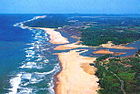

| show Wetlands and conservation |
|---|
| show Biodiversity of South Africa |
|---|
| show Authority control |
|---|
- Mangroves
- Aquatic biomes
- Aquatic ecology
- Blue carbon
- Mangrove ecoregions
- Terrestrial biomes
- Plant common names
- Oceanographical terminology