Maputaland–Pondoland bushland and thickets
| Maputaland-Pondoland bushland and thickets | |
|---|---|
 | |
 Map of the Maputaland-Pondoland bushland and thickets | |
| Ecology | |
| Realm | Afrotropical |
| Biome | montane grasslands and shrublands |
| Borders | Albany thickets, Drakensberg montane grasslands, woodlands, and forests, Kwazulu-Cape coastal forest mosaic, and Nama Karoo |
| Geography | |
| Area | 19,400 km2 (7,500 sq mi) |
| Countries | South Africa |
| Conservation | |
| Conservation status | Critical/endangered |
The Maputaland-Pondoland bushland and thickets is one of the ecoregions of South Africa. It consists of the montane shrubland biome.[1]
Geography[]
The ecoregion occupies the foothills of the Drakensberg mountains, covering an area of 19,500 square kilometers (7,500 sq mi) in South Africa's Eastern Cape and KwaZulu-Natal provinces. It is bounded on the east by the KwaZulu-Cape coastal forest mosaic, which lies in the humid coastal strip along the Indian Ocean; to the west it is bounded by the higher-elevation Drakensberg montane grasslands, woodlands and forests. To the south, it transitions to the drier Albany thickets, which are characterized by more succulent and spiny plants.
Climate[]
The ecoregion has a dry subtropical climate. Rainfall varies from 800 mm to 450 mm per year, with approximately three-quarters of the rain falling in the warm summer months between October and March. Frosts are rare because of the moderating influence of the Indian Ocean.
Flora[]
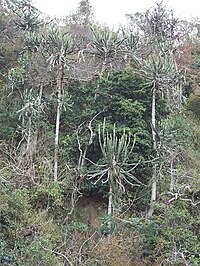
The typical vegetation is sclerophyll evergreen shrubs, which form dense, closed canopy thickets up to six meters in height. The ecoregion, which is in a transition between moist and dry, montane and lowland, and temperate and tropical, has a rich diversity of species, although with few endemics.
Fauna[]
The ecoregion is home to a variety of animal species, including endangered black rhinos (Diceros bicornis) and white rhinos (Ceratotherium simum).
Protected areas[]
A 1994 survey found that about 7.5% of the ecoregion is in protected areas. Protected areas include the Great Fish River Nature Reserve, Oribi Gorge Nature Reserve, and Thomas Baines Nature Reserve.[2]
See also[]
- Maputaland-Pondoland-Albany Hotspot – Southern Africa biodiversity hotspot
- Maputaland – Natural region in South Africa in northern KwaZulu-Natal
- EmaMpondweni, also known as Pondoland
- Wild Coast – Section of the coast of the Eastern Cape, South Africa
References[]
- ^ Ecoregions of South Africa Archived 2011-11-16 at the Wayback Machine
- ^ "Maputaland-Pondoland bushland and thickets". Terrestrial Ecoregions. World Wildlife Fund.
External links[]
- "Maputaland-Pondoland bushland and thickets". Terrestrial Ecoregions. World Wildlife Fund.
- Maputaland-Pondoland-Albany
Coordinates: 30°40′S 29°24′E / 30.667°S 29.400°E

Biodiversity of South Africa | |||||||||||||||||||||||||||
|---|---|---|---|---|---|---|---|---|---|---|---|---|---|---|---|---|---|---|---|---|---|---|---|---|---|---|---|
| |||||||||||||||||||||||||||
| |||||||||||||||||||||||||||
| |||||||||||||||||||||||||||
| |||||||||||||||||||||||||||
| |||||||||||||||||||||||||||
| |||||||||||||||||||||||||||
| |||||||||||||||||||||||||||
| |||||||||||||||||||||||||||
| |||||||||||||||||||||||||||
- Afromontane ecoregions
- Afrotropical ecoregions
- Drakensberg
- Ecoregions of South Africa
- Grasslands of South Africa
- Montane grasslands and shrublands