Hadji Muhtamad
Hadji Muhtamad | |
|---|---|
| Municipality of Hadji Muhtamad | |
 Flag  Seal | |
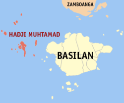 Map of Basilan with Hadji Muhtamad highlighted | |
OpenStreetMap  | |
 Hadji Muhtamad Location within the Philippines | |
| Coordinates: 6°38′N 121°37′E / 6.63°N 121.62°ECoordinates: 6°38′N 121°37′E / 6.63°N 121.62°E | |
| Country | Philippines |
| Region | Bangsamoro Autonomous Region in Muslim Mindanao |
| Province | Basilan |
| District | Lone district |
| Founded | August 25, 2007 |
| Barangays | 10 (see Barangays |
| Government | |
| • Type | Sangguniang Bayan |
| • Mayor | Nerwelyn L. Mansul |
| • Vice Mayor | Abdulmannan H. Bayro |
| • Representative | Mujiv S. Hataman |
| • Municipal Council | Members |
| • Electorate | 9,373 voters (2019) |
| Area | |
| • Total | 173.22 km2 (66.88 sq mi) |
| Elevation | 1.0 m (3.3 ft) |
| Highest elevation | 230 m (750 ft) |
| Lowest elevation | 0 m (0 ft) |
| Population (2020 census) [3] | |
| • Total | 26,867 |
| • Density | 160/km2 (400/sq mi) |
| • Households | 3,921 |
| Economy | |
| • Poverty incidence | 57.20% (2015)[4] |
| • Revenue | ₱105,156,261.00 (2020) |
| • Assets | ₱126,192,449.69 (2020) |
| • Expenditure | ₱85,552,106.73 (2020) |
| • Liabilities | ₱103,743,481.14 (2020) |
| Service provider | |
| • Electricity | Basilan Electric Cooperative (BASELCO) |
| Time zone | UTC+8 (PST) |
| ZIP code | 7301 |
| PSGC | |
| IDD : area code | +63 (0)62 |
| Native languages | Yakan Chavacano Tagalog |

Hadji Muhtamad, officially the Municipality of Hadji Muhtamad (Tausūg: Lupah Hadji Muhtamad; Chavacano: Municipalidad de Hadji Muhtamad; Tagalog: Bayan ng Hadji Muhtamad), is a municipality in the province of Basilan, Philippines. According to the 2020 census, it has a population of 26,867 people. [3]
Hadji Muhtamad was created out of the 10 barangays of Lantawan that were not on Basilan Island, through Muslim Mindanao Autonomy Act No. 200,[5] which was subsequently ratified in a plebiscite held on August 25, 2007.[6]
Geography[]
Its territory includes the Pilas Islands and surrounding islets, west of Basilan Island.
Barangays[]
Hadji Muhtamad is politically subdivided into 10 barangays.[7]
| PSGC | Barangay | Population | ±% p.a. | |||
|---|---|---|---|---|---|---|
| 2020 [3] | 2010 [8] | |||||
| 150712001 | Baluk-baluk | 5.9% | 1,585 | 1,063 | 4.20% | |
| 150712002 | Dasalan | 11.1% | 2,970 | 1,518 | 7.15% | |
| 150712003 | Lubukan | 12.1% | 3,260 | 1,730 | 6.74% | |
| 150712004 | Luukbongsod | 7.2% | 1,928 | 988 | 7.12% | |
| 150712005 | Mananggal | 3.0% | 800 | 763 | 0.49% | |
| 150712006 | Palahangan | 7.1% | 1,920 | 787 | 9.61% | |
| 150712007 | Panducan | 6.1% | 1,652 | 1,087 | 4.40% | |
| 150712008 | Sangbay Big | 13.2% | 3,549 | 1,330 | 10.62% | |
| 150712009 | Sangbay Small | 10.8% | 2,900 | 1,416 | 7.65% | |
| 150712010 | Tausan | 16.8% | 4,521 | 1,567 | 11.52% | |
| Total | 26,867 | 12,249 | 8.42% | |||
Climate[]
| Climate data for Hadji Muhtamad, Basilan | |||||||||||||
|---|---|---|---|---|---|---|---|---|---|---|---|---|---|
| Month | Jan | Feb | Mar | Apr | May | Jun | Jul | Aug | Sep | Oct | Nov | Dec | Year |
| Average high °C (°F) | 27 (81) |
27 (81) |
27 (81) |
28 (82) |
28 (82) |
28 (82) |
28 (82) |
28 (82) |
28 (82) |
28 (82) |
28 (82) |
28 (82) |
28 (82) |
| Average low °C (°F) | 27 (81) |
26 (79) |
27 (81) |
27 (81) |
28 (82) |
28 (82) |
28 (82) |
28 (82) |
28 (82) |
28 (82) |
28 (82) |
27 (81) |
28 (81) |
| Average precipitation mm (inches) | 129 (5.1) |
91 (3.6) |
102 (4.0) |
106 (4.2) |
228 (9.0) |
280 (11.0) |
282 (11.1) |
278 (10.9) |
202 (8.0) |
281 (11.1) |
229 (9.0) |
141 (5.6) |
2,349 (92.6) |
| Average rainy days | 15.7 | 13.4 | 14.8 | 14.3 | 22.9 | 24.4 | 24.7 | 24.6 | 21.1 | 23.4 | 20.7 | 17.5 | 237.5 |
| Source: Meteoblue (modeled/calculated data, not measured locally)[9] | |||||||||||||
Demographics[]
| Year | Pop. | ±% p.a. |
|---|---|---|
| 2007 | 20,292 | — |
| 2010 | 12,249 | −16.78% |
| 2015 | 25,085 | +14.63% |
| 2020 | 26,867 | +1.36% |
| Source: Philippine Statistics Authority [10] [8] [11][12] | ||
In the 2020 census, Hadji Muhtamad had a population of 26,867. [3]
Economy[]
| Poverty Incidence of Hadji Muhtamad | |
| Source: Philippine Statistics Authority[13][14][15] | |
References[]
- ^ Municipality of Hadji Muhtamad | (DILG)
- ^ "2015 Census of Population, Report No. 3 – Population, Land Area, and Population Density" (PDF). Philippine Statistics Authority. Quezon City, Philippines. August 2016. ISSN 0117-1453. Archived (PDF) from the original on May 25, 2021. Retrieved July 16, 2021.
- ^ a b c d Census of Population (2020). "BARMM". Total Population by Province, City, Municipality and Barangay. PSA. Retrieved 8 July 2021.
- ^ https://psa.gov.ph/sites/default/files/City%20and%20Municipal-level%20Small%20Area%20Poverty%20Estimates_%202009%2C%202012%20and%202015_0.xlsx; publication date: 10 July 2019; publisher: Philippine Statistics Authority.
- ^ "Muslim Mindanao Autonomy Act No. 200; An Act Creating the Municipality of Hadji Muhtamad in the Province of Basilan and for Other Purposes" (PDF). Regional Legislative Assembly, Autonomous Region in Muslim Mindanao. Archived from the original (PDF) on 4 February 2016. Retrieved 27 January 2016.
- ^ "Five (5) New Cities, Two (2) Municipalities and a Barangay created in the Third Quarter of 2007". National Statistical Coordination Board. 13 November 2007. Archived from the original on 24 November 2007. Retrieved 10 November 2016.
- ^ "Municipal: Hadji Muhtamad". PSGC Interactive. Quezon City, Philippines: Philippine Statistics Authority. Retrieved 8 January 2016.
- ^ a b Census of Population and Housing (2010). "ARMM – Autonomous Region in Muslim Mindanao". Total Population by Province, City, Municipality and Barangay. NSO. Retrieved 29 June 2016.
- ^ "Hadji Muhtamad, Basilan : Average Temperatures and Rainfall". Meteoblue. Retrieved 29 January 2019.
- ^ Census of Population (2015). "ARMM – Autonomous Region in Muslim Mindanao". Total Population by Province, City, Municipality and Barangay. PSA. Retrieved 20 June 2016.
- ^ Censuses of Population (1903–2007). "ARMM – Autonomous Region in Muslim Mindanao". Table 1. Population Enumerated in Various Censuses by Province/Highly Urbanized City: 1903 to 2007. NSO.
- ^ "Province of Basilan". Municipality Population Data. Local Water Utilities Administration Research Division. Retrieved 17 December 2016.
- ^ "Poverty incidence (PI):". Philippine Statistics Authority. Retrieved 28 December 2020.
- ^ https://psa.gov.ph/sites/default/files/2012%20Municipal%20and%20City%20Level%20Poverty%20Estima7tes%20Publication%20%281%29.pdf; publication date: 31 May 2016; publisher: Philippine Statistics Authority.
- ^ https://psa.gov.ph/sites/default/files/City%20and%20Municipal-level%20Small%20Area%20Poverty%20Estimates_%202009%2C%202012%20and%202015_0.xlsx; publication date: 10 July 2019; publisher: Philippine Statistics Authority.
External links[]
Lamitan (capital) | ||
| Municipalities |  | |
| Component cities |
| |
This article about a location in the Bangsamoro Autonomous Region in Muslim Mindanao is a stub. You can help Wikipedia by . |
- Municipalities of Basilan
- Island municipalities in the Philippines
- Bangsamoro geography stubs