Hafslo
Hafslo herad | |
|---|---|
 View of Hafslo | |
 Sogn og Fjordane within Norway | |
 Hafslo within Sogn og Fjordane | |
| Coordinates: 61°18′39″N 07°11′08″E / 61.31083°N 7.18556°ECoordinates: 61°18′39″N 07°11′08″E / 61.31083°N 7.18556°E | |
| Country | Norway |
| County | Sogn og Fjordane |
| District | Sogn |
| Established | 1 Jan 1838 |
| Disestablished | 1 Jan 1963 |
| Administrative centre | Hafslo |
| Area | |
| • Total | 583 km2 (225 sq mi) |
| *Area at municipal dissolution. | |
| Population (1963) | |
| • Total | 2,384 |
| • Density | 4.1/km2 (11/sq mi) |
| Demonym(s) | Hafslobygding[1] |
| Time zone | UTC+01:00 (CET) |
| • Summer (DST) | UTC+02:00 (CEST) |
| ISO 3166 code | NO-1425 |
| Created as | Formannskapsdistrikt in 1838 |
| Succeeded by | Luster in 1963 |

Hafslo is a former municipality in the old Sogn og Fjordane county, Norway. The 538-square-kilometre (208 sq mi)[2] municipality existed from 1838 until its dissolution in 1963. It is located in the present-day Luster Municipality (in Vestland county) in the traditional district of Sogn. The former municipality included the villages of Kinsedalen, Ornes, and Kroken on the east side of the Lustrafjorden. It also included the villages of Solvorn, Hafslo, , and the whole Veitastrond valley on the west side of the Lustrafjorden. The municipality surrounded the lakes Hafslovatnet and . The administrative centre of the municipality was the village of Hafslo, where Hafslo Church was located.
Name[]
The name comes from the old Hafslo farm (Old Norse: Hafrsló), since Hafslo Church is located there. The first element of the name comes from the old male name Hafr or from the word for "goat" (also hafr). The second element of the name comes from the old word ló meaning "meadow", probably due to the excellent farming areas nearby.[3]
History[]
Hafslo was established as a municipality on 1 January 1838 (see formannskapsdistrikt law). During the 1960s, there were many municipal mergers across Norway due to the work of the Schei Committee. On 1 January 1963, the municipality of Hafslo (population: 2,384) was merged with the neighboring municipalities of Luster (population: 2,674) and Jostedal (population: 796) to form the new, larger municipality of Luster.[4]
Government[]
Municipal council[]
The municipal council (Heradsstyre) of Hafslo was made up of 21 representatives that were elected to four year terms. The party breakdown of the final municipal council was as follows:
| Party Name (in Nynorsk) | Number of representatives | |
|---|---|---|
| Labour Party (Arbeidarpartiet) | 7 | |
| Conservative Party (Høgre) | 2 | |
| Christian Democratic Party (Kristeleg Folkeparti) | 3 | |
| Centre Party (Senterpartiet) | 5 | |
| Liberal Party (Venstre) | 3 | |
| Local List(s) (Lokale lister) | 1 | |
| Total number of members: | 21 | |
| Party Name (in Nynorsk) | Number of representatives | |
|---|---|---|
| Labour Party (Arbeidarpartiet) | 7 | |
| Conservative Party (Høgre) | 3 | |
| Christian Democratic Party (Kristeleg Folkeparti) | 3 | |
| Farmers' Party (Bondepartiet) | 5 | |
| Liberal Party (Venstre) | 3 | |
| Total number of members: | 21 | |
| Party Name (in Nynorsk) | Number of representatives | |
|---|---|---|
| Labour Party (Arbeidarpartiet) | 9 | |
| Conservative Party (Høgre) | 5 | |
| Farmers' Party (Bondepartiet) | 8 | |
| Joint List(s) of Non-Socialist Parties (Borgarlege Felleslister) | 6 | |
| Total number of members: | 28 | |
| Party Name (in Nynorsk) | Number of representatives | |
|---|---|---|
| Labour Party (Arbeidarpartiet) | 4 | |
| Christian Democratic Party (Kristeleg Folkeparti) | 1 | |
| Farmers' Party (Bondepartiet) | 2 | |
| List of workers, fishermen, and small farmholders (Arbeidarar, fiskarar, småbrukarar liste) | 5 | |
| Joint List(s) of Non-Socialist Parties (Borgarlege Felleslister) | 6 | |
| Local List(s) (Lokale lister) | 10 | |
| Total number of members: | 28 | |
| Party Name (in Nynorsk) | Number of representatives | |
|---|---|---|
| Labour Party (Arbeidarpartiet) | 4 | |
| Liberal Party (Venstre) | 2 | |
| List of workers, fishermen, and small farmholders (Arbeidarar, fiskarar, småbrukarar liste) | 9 | |
| Local List(s) (Lokale lister) | 13 | |
| Total number of members: | 28 | |
| Party Name (in Nynorsk) | Number of representatives | |
|---|---|---|
| Labour Party (Arbeidarpartiet) | 6 | |
| Conservative Party (Høgre) | 1 | |
| Farmers' Party (Bondepartiet) | 7 | |
| Liberal Party (Venstre) | 4 | |
| List of workers, fishermen, and small farmholders (Arbeidarar, fiskarar, småbrukarar liste) | 1 | |
| Joint List(s) of Non-Socialist Parties (Borgarlege Felleslister) | 4 | |
| Local List(s) (Lokale lister) | 5 | |
| Total number of members: | 28 | |
Notable residents[]
- Sylfest Lomheim (born 1945) – Norwegian linguist
- Jens Sterri (born 1923) – civil servant
- Kjellfred Weum (born 1940) – hurdler
Media gallery[]

The Hafslo village area in the central part of the municipality

The Ornes area in eastern Hafslo municipality

The Veitastrondsvatnet lake and the Jostedalsbreen glacier (northern end of the municipality
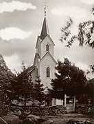
Hafslo Church


See also[]
References[]
- ^ "Navn på steder og personer: Innbyggjarnamn" (in Norwegian). Språkrådet.
- ^ Helland, Amund (1901). "Hafslo herred". Norges land og folk: Nordre Bergenhus amt (in Norwegian). XIV. Kristiania, Norway: H. Aschehoug & Company. p. 58. Retrieved 2019-09-28.
- ^ Rygh, Oluf (1919). Norske gaardnavne: Nordre Bergenhus amt (in Norwegian) (12 ed.). Kristiania, Norge: W. C. Fabritius & sønners bogtrikkeri. pp. 40–41.
- ^ Jukvam, Dag (1999). "Historisk oversikt over endringer i kommune- og fylkesinndelingen" (PDF) (in Norwegian). Statistisk sentralbyrå. Cite journal requires
|journal=(help) - ^ "Kommunevalgene og Ordførervalgene 1959" (PDF) (in Norwegian). Oslo: Statistisk sentralbyrå. 1960. Retrieved 2020-02-16.
- ^ "Kommunevalgene og Ordførervalgene 1955" (PDF) (in Norwegian). Oslo: Statistisk sentralbyrå. 1957. Retrieved 2020-02-16.
- ^ "Kommunevalgene og Ordførervalgene 1951" (PDF) (in Norwegian). Oslo: Statistisk sentralbyrå. 1952. Retrieved 2020-02-16.
- ^ "Kommunevalgene og Ordførervalgene 1947" (PDF) (in Norwegian). Oslo: Statistisk sentralbyrå. 1948. Retrieved 2020-02-16.
- ^ "Kommunevalgene og Ordførervalgene 1945" (PDF) (in Norwegian). Oslo: Statistisk sentralbyrå. 1947. Retrieved 2020-02-16.
- ^ "Kommunevalgene og Ordførervalgene 1937" (PDF) (in Norwegian). Oslo: Statistisk sentralbyrå. 1938. Retrieved 2020-05-11.
External links[]
 Luster travel guide from Wikivoyage
| |||
 | Towns and cities |  | |
| Municipalities | |||
- Luster, Norway
- Former municipalities of Norway
- 1838 establishments in Norway
- 1963 disestablishments in Norway