Hainshallig
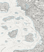
1858 map of North Frisian islands, including Hainshallig
Hainshallig (also spelled Hayenshallig) was a small Hallig in the North Frisian Wadden Sea, located east of the Hallig of Hooge, that was flooded and sank in 1860.[1] At the time, Hainshallig was leased to a Hooge resident as part of a leasehold estate and was used for the production of hay.[2] A levee may have once led from Hooge to Hainshallig.[3] The area belonged to the Duchy of Schleswig, which was a fiefdom of the Danish crown, now Germany.
References[]
- ^ Röhr, Hanswerner. "Die Halligen an der Westküste gelten vorerst als sicher" (PDF). Berichte und Geschichte aus Husum und Umgebung (in German).
- ^ Ersch, Johann Samuel (1833). Allgemeine Encyclopädie der Wissenschaften und Künste in alphabetischer Folge (in German).
- ^ (1884). Agrarhistorische Abhandlungen. Vol. 2.
| West Frisian Islands (Netherlands) |
|  | |||||
|---|---|---|---|---|---|---|---|
| East Frisian Islands (Germany) |
| ||||||
| Heligoland Bight (Germany) | |||||||
| North Frisian Islands (Germany) |
| ||||||
| Danish Wadden Sea Islands (Denmark) |
| ||||||
Coordinates: 54°34′24″N 8°36′31″E / 54.573355°N 8.608475°E

This Nordfriesland location article is a stub. You can help Wikipedia by . |
This article about an island is a stub. You can help Wikipedia by . |
Categories:
- Halligen
- Former islands of Germany
- Former islands of Denmark
- Nordfriesland geography stubs
- Island stubs