Hamaam, Israel
Hamaam
חַמָּם, חמאם حمام | |
|---|---|
 | |
 Hamaam | |
| Coordinates: 32°49′41.8″N 35°29′32.13″E / 32.828278°N 35.4922583°ECoordinates: 32°49′41.8″N 35°29′32.13″E / 32.828278°N 35.4922583°E | |
| Country | |
| District | Northern |
| Council | al-Batuf |
| Population (2019)[1] | 1,503 |

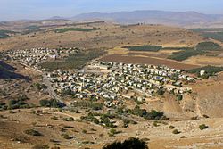
Hamaam (Arabic: حمام; Hebrew: חַמָּם), or Wadi Hamam, is an Arab village in northern Israel, located near the Sea of Galilee, at the foot of Mount Nitai and across the Wadi Hamam valley from Mount Arbel. It is the easternmost part of the al-Batuf Regional Council. It contains one fairly modern mosque and the trail head for the steep ascent of Mount Arbel. In 2019 its population was 1,503.[1]
Archaeological sites[]
Khirbet Wadi Hamam[]
Khirbet Wadi Hamam is an archaeological site practically on the outskirts of Hamaam.[2] It was registered as Khirbet el-Wereidat in the PEF's 1870 Survey of Western Palestine,[3] from which the modern Hebrew name-Hurbat Vradim, also spelled Hurvat/Horvat Veradim-was derived.[citation needed] The site was excavated between 2007-2012 by a team under dig director Uzi Leibner of Hebrew University and yielded the remains of a large Roman-period Jewish village that was abandoned after a decades-long process of decline around the year 400, at the beginning of the Byzantine period.[2][4] The village was situated at the foot of Mount Nitai and thus on the ancient road connecting the central Galilee, through Wadi Hamam, with the Sea of Galilee.[2]
Ancient synagogue[]
The most important find is a synagogue with a very interesting and partially preserved mosaic floor. It has also remains of palestinian homes from 1948 [5]name="HUJI2011"/>
Mount Nitai fortifications[]
The fortifications atop Mount Nitai, which is a nature reserve and off limits for visitors, have also been surveyed and partially excavated with the purpose of dating them and placing them in a historical context.[2]
See also[]
- Arab localities in Israel
- Al-Khisas, Hula Valley, the original pre-1948 village of the Wadi Hamam inhabitants
- 'Akbara, where inhabitants of Al-Khisas were forcibly evacuated to in 1949 until agreeing to resettlement in Wadi Hamam
- Al-Muftakhira, Hula Valley, mentioned by W. Khalidi as the original pre-1948 village of the inhabitants[dubious ]
References[]
| Wikimedia Commons has media related to Hamaam. |
- ^ Jump up to: a b "Population in the Localities 2019" (XLS). Israel Central Bureau of Statistics. Retrieved 16 August 2020.
- ^ Jump up to: a b c d "Archaeological Excavations at Khirbet Wadi Hamam – A Roman Period Village in the Eastern Lower Galilee, Israel: Summer 2011" (PDF). Hebrew University. 2011. Archived from the original (PDF) on 5 July 2015. Retrieved 16 January 2015.
- ^ , accessed in January 2017
- ^ Uzi Leibner, Excavations at Khirbet Wadi Hamam (Lower Galilee): the synagogue and the settlement, Journal of Roman Archaeology 23 (2010), pp. 220-237. Accessed 18 July 2019.
- ^ "A Journey Home".
This geography of Israel article is a stub. You can help Wikipedia by . |
- Arab villages in Israel
- Al-Batuf Regional Council
- Populated places in Northern District (Israel)
- Israel geography stubs