Northern District (Israel)
Northern District | |
|---|---|
| - transcription(s) | |
| • Arabic | منطقة الشمال |
| • Hebrew | מחוז הצפון |
 | |
| Cities | 17 |
| Local Councils | 61 |
| Regional Councils | 15 |
| Capital | Nof HaGalil |
| Largest | Nazareth |
| Area | |
| • Total | 4,478 km2 (1,729 sq mi) |
| Population (2016) | |
| • Total | 1,401,300 |
| ISO 3166 code | IL-Z |
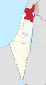
The Northern District (Hebrew: מחוז הצפון, Meḥoz HaTzafon; Arabic: منطقة الشمال, Minṭaqat ash-Shamāl) is one of Israel's six administrative districts. The Northern District has a land area of 4,478 km², which increases to 4,638 km² when both land and water are included. The district capital is Nof HaGalil and the largest city is Nazareth.
The Golan Heights has been run as a sub-district of the North District of Israel since the 1981 Golan Heights Law was passed, although the claim is only recognized by the United States[1] while United Nations Security Council Resolution 497 condemns the annexation but does not enforce it. The Golan Heights covers a land area of 1,154 km² and the remainder of the Northern District covers 3,324 km² (3,484 km² including water).
Demographics[]
According to the Israeli Central Bureau of Statistics data for 2016:[2]
- Total population: 1,390,900 (2016)
- Ethnic:
In the Israeli census, no distinction is made between Palestinian Citizens of Israel and Syrian inhabitants of the Golan Heights, many of whom are not citizens of Israel, but of Syria.
- Religious:
- Jews: 599,700 (43.1%)
- Muslims: 540,600 (38.9%)
- Druze: 111,400 (8%)
- Arab Christians: 93,100 (6.7%)
- Not classified: 40,000 (2.9%)
- Density: 311/km²
The Northern District is the only district of Israel where the majority of inhabitants are Arabs.
Administrative regions[]


| Subdistricts | |||||
|---|---|---|---|---|---|
| Cities | Local Councils | Regional Councils | |||
|
| ||||
See also[]
References[]
- ^ Romo, Vanessa (25 March 2019). "Trump Formally Recognizes Israeli Sovereignty Over Golan Heights". NPR.
- ^ "Population, by Population Group, Religion, Age and Sex, District and Sub-District" (PDF). Israel Central Bureau of Statistics. 2017. Archived from the original (PDF) on May 9, 2018. Retrieved May 8, 2018.
| show Places adjacent to Northern District (Israel) |
|---|

| show Authority control |
|---|
Coordinates: 32°50′N 35°20′E / 32.833°N 35.333°E

This geography of Israel article is a stub. You can help Wikipedia by . |
- Districts of Israel
- Northern District (Israel)
- Israel geography stubs