Hankensbüttel
This article does not cite any sources. (December 2009) |
Hankensbüttel | |
|---|---|
 Coat of arms | |
show Location of Hankensbüttel within Gifhorn district | |
 Hankensbüttel | |
| Coordinates: 52°44′N 10°36′E / 52.733°N 10.600°ECoordinates: 52°44′N 10°36′E / 52.733°N 10.600°E | |
| Country | Germany |
| State | Lower Saxony |
| District | Gifhorn |
| Municipal assoc. | Hankensbüttel |
| Government | |
| • Mayor | Martin Rausch (SPD) |
| Area | |
| • Total | 34.82 km2 (13.44 sq mi) |
| Elevation | 82 m (269 ft) |
| Population (2020-12-31)[1] | |
| • Total | 4,538 |
| • Density | 130/km2 (340/sq mi) |
| Time zone | UTC+01:00 (CET) |
| • Summer (DST) | UTC+02:00 (CEST) |
| Postal codes | 29386 |
| Dialling codes | 05832 |
| Vehicle registration | GF |


Hankensbüttel is a municipality in the Samtgemeinde Hankensbüttel in the district of Gifhorn, Lower Saxony, Germany. It is situated approximately 25 km south of Uelzen, and 30 km north of Gifhorn. The Municipality Hankensbüttel includes the villages of Alt Isenhagen, Emmen and Hankensbüttel,

Lutheran church

Old monastery
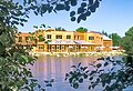
Main building of the Otter Centre

Inn


History[]
The first documentary mentioning of Hankensbüttel was in the year 1051 by the name Honengesbuthele. The document is from Henry III. In this time the Saxon dynasty of Billung owned the region
Politics[]
Administration[]
Hankensbüttel is also the seat of the Samtgemeinde Hankensbüttel ("collective municipality"), which consists of the following municipalities:
- Dedelstorf
- Hankensbüttel
- Obernholz
- Sprakensehl
- Steinhorst
Community council[]
The Community council consists of 15 community members and was elected on 10 September 2006:
- CDU - 7 Seats
- SPD - 2 Seats
- Green Party - 2 Seats
- FDP - 2 Seats
- Independent - 2 Seats
| Wikimedia Commons has media related to Gifhorn/Hankensbüttel. |
References[]
| show Towns and municipalities in Gifhorn (district) |
|---|
| show Authority control |
|---|
This Gifhorn district location article is a stub. You can help Wikipedia by . |
- Municipalities in Lower Saxony
- Gifhorn (district)
- Braunschweig region geography stubs