Wahrenholz
Wahrenholz | |
|---|---|
 Coat of arms | |
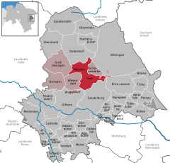
show Location of Wahrenholz within Gifhorn district | |
 Wahrenholz | |
| Coordinates: 52°37′N 10°36′E / 52.617°N 10.600°ECoordinates: 52°37′N 10°36′E / 52.617°N 10.600°E | |
| Country | Germany |
| State | Lower Saxony |
| District | Gifhorn |
| Municipal assoc. | Wesendorf |
| Subdivisions | 5 |
| Government | |
| • Mayor | Herbert Pieper (CDU) |
| Area | |
| • Total | 57.99 km2 (22.39 sq mi) |
| Elevation | 55 m (180 ft) |
| Population (2020-12-31)[1] | |
| • Total | 3,673 |
| • Density | 63/km2 (160/sq mi) |
| Time zone | UTC+01:00 (CET) |
| • Summer (DST) | UTC+02:00 (CEST) |
| Postal codes | 29399 |
| Dialling codes | 05835 |
| Vehicle registration | GF |


Wahrenholz is a municipality in the district of Gifhorn, in Lower Saxony, Germany. The Municipality Wahrenholz includes the villages of Betzhorn, Teichgut, Wahrenholz, Weißenberge and Weißes Moor.
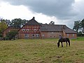
Idyll in Betzhorn

Restaurant in Teichgut

The Lutheran church in Wahrenholz

Water mill in Wahrenholz


References[]
| show Towns and municipalities in Gifhorn (district) |
|---|
| show Authority control |
|---|
This Gifhorn district location article is a stub. You can help Wikipedia by . |
Categories:
- Municipalities in Lower Saxony
- Gifhorn (district)
- Braunschweig region geography stubs