Hel, Poland
This article needs additional citations for verification. (May 2015) |
Hel | |
|---|---|
  View of Hel (top) and timber framed heritage houses (bottom) | |
 Flag  Coat of arms | |
 | |
 Hel | |
| Coordinates: 54°36′42″N 18°48′29″E / 54.61167°N 18.80806°E | |
| Country | |
| Voivodeship | Pomeranian |
| County | Puck |
| Gmina | Hel (urban gmina) |
| Established | 12th century |
| Town rights | 1351–1872, 1963 |
| Government | |
| • Mayor | Mirosław Wądołowski[2] |
| Area | |
| • Total | 21.27 km2 (8.21 sq mi) |
| Population (2017) | |
| • Total | 3,276[1] |
| Time zone | UTC+1 (CET) |
| • Summer (DST) | UTC+2 (CEST) |
| Postal code | 84-150 |
| Area code(s) | +48 58 |
| Car plates | GPU |
| Website | https://www.hel.eu/ |


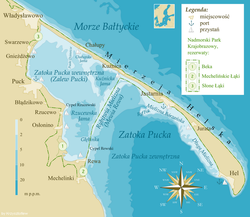
Hel [xɛl] (![]() listen) (Kashubian: Hél [xel],[3] German: Hela) is a town in Puck County, Pomeranian Voivodeship, Poland, located on the tip of the Hel Peninsula, some 33 kilometres (21 miles) from the Polish mainland.
listen) (Kashubian: Hél [xel],[3] German: Hela) is a town in Puck County, Pomeranian Voivodeship, Poland, located on the tip of the Hel Peninsula, some 33 kilometres (21 miles) from the Polish mainland.
History[]
Early developments[]
The Kashubian village of Hel was first mentioned in 1198 as a centre of herring trade area named Gellen. In one of the Danish chronicles of 1219 it is mentioned that a damaged ship of King Valdemar II the Victorious was set ashore on an "Island of Hel". By the 13th century the village became one of the most important trade centres of the area, competing with the nearby town of Gdańsk. It was then that the village was granted city rights by Duke Świętopełk II the Great of Pomerania. The privileges were later confirmed in 1378 when the town came under the rule of the Teutonic Knights.
Initially the town was some 1.5 km (1 mi) from its present-day centre. It contained a church, hospital, city house, two market places, several guest houses and a small port. However, during the 15th century the peninsula started to shrink through marine erosion and soon the town was moved to a safer place. In 1417 St Peter's Church was built in the town, devoted to the patron saint of fishermen. Hel experienced a period of growth, but was later left behind by the faster-growing city of Gdańsk. In 1466 King Casimir IV of Poland granted the town as a fief to the rulers of Gdańsk, which ended the century-long struggle for economical domination over the Gdańsk Bay. In 1526 King Sigismund I the Old withdrew all privileges previously granted to Hel and sold the town and the peninsula to the city authorities of Gdańsk. Since then Hel's fate was tied to the fortunes of its bigger neighbour.
In the 17th and 18th centuries prolonged warfare and a series of natural disasters severely damaged the town. It was severely depopulated and in 1872 the government of the newly formed German state abolished the city rights granted to Hel six centuries previously. After that the village of Hela (as it is called in German) lost much of its significance.
Modern times[]

The period of decline was halted in 1893 when a fishing harbour was built in the village. It provided a shelter for fishing vessels, but also became a popular destination for weekend trips of the inhabitants of Danzig and Zoppot. In 1896 the village was granted the status of a sea-side resort.
As a result of World War I and the Treaty of Versailles Poland was re-established as an independent nation. Hel, before the war a predominately German village (93% in 1905[4]), became part of Poland. In 1921 a new railway was built along the peninsula connecting the town to the mainland. The authorities of the Pomeranian Voivodeship also planned to build a road to the village, but the peninsula was found too narrow at the time. Soon Hel became one of the most important tourism centres in Polish Pomerania. New suburbs of villas were built for tourists, as well as a new church, school, fishing institute and geophysical observatory. In addition, the village became one of the two main naval bases of the Polish Navy. The harbour was expanded and in 1936 the president declared the peninsula a "Fortified Area" under jurisdiction of the Polish Army. The naval base was expanded significantly and a battery of coastal artillery was built to provide cover for the military facilities.
During the invasion of Poland the Hel Peninsula was one of the longest-defended pockets of Polish Army resistance. Approximately 3,000 soldiers of the (Grupa Obrony Wybrzeża) units under Kmdr Włodzimierz Steyer defended the area until 2 October 1939. Shortly before capitulation, Polish military engineers detonated a number of torpedo warheads, which separated the peninsula from the mainland transforming it into an island. During World War II the Kriegsmarine used the Hel naval base to train U-boat crews. At the end of the war the village was the last part of Polish soil to be liberated: the German units encircled there only surrendered on 14 May 1945, six days after Germany had capitulated.
After the war the village yet again became a naval base. In 1960 a road linking Hel with Jastarnia on the mainland was built. Three years later city rights were reintroduced. Since then the tourist industry started to recover and several hotels, guest houses and pensions were built. In 1996 the Polish Navy sold all remaining parts of the peninsula to the civilian authorities and only a small naval base is there today.
The harbour now serves primarily as a yacht marina, though there are some fishing boats and ferries to Gdańsk, Sopot and Gdynia in the summer.
Hel houses a sea life biological laboratory and there are interesting examples of naval armament and equipment exhibited throughout the town. There is popular beach along the shore between the inner and outer harbour walls, with a seal sanctuary (the Fokarium) just behind it. There is a [5] that forms part of the National Maritime Museum, Gdańsk[6] in an old church on the sea front.
The most easterly edge of Hel, which was once a military territory, can now be accessed by the general public making it possible to walk all the way around the peninsula.
Hel is the setting for the Polish crime series Zbrodnia (2014–2015 ) “The Crime” in English.[1]
Climate[]
Hel has an oceanic climate (Köppen: Cfb). Its peninsular location generates a unique climate in Poland and more similar with the northwest of Europe.[7]
| hideClimate data for Hel (Hel Lighthouse), elevation: 1 m, 1961–1990 normals and extremes | |||||||||||||
|---|---|---|---|---|---|---|---|---|---|---|---|---|---|
| Month | Jan | Feb | Mar | Apr | May | Jun | Jul | Aug | Sep | Oct | Nov | Dec | Year |
| Record high °C (°F) | 10.0 (50.0) |
12.9 (55.2) |
20.5 (68.9) |
21.8 (71.2) |
28.0 (82.4) |
31.2 (88.2) |
33.2 (91.8) |
31.8 (89.2) |
27.3 (81.1) |
23.2 (73.8) |
15.9 (60.6) |
11.1 (52.0) |
33.2 (91.8) |
| Average high °C (°F) | 0.9 (33.6) |
1.3 (34.3) |
4.6 (40.3) |
9.4 (48.9) |
15.0 (59.0) |
19.1 (66.4) |
21.1 (70.0) |
21.0 (69.8) |
17.3 (63.1) |
12.2 (54.0) |
6.6 (43.9) |
3.0 (37.4) |
11.0 (51.8) |
| Daily mean °C (°F) | −0.7 (30.7) |
−0.6 (30.9) |
1.7 (35.1) |
5.2 (41.4) |
10.3 (50.5) |
14.7 (58.5) |
16.9 (62.4) |
16.9 (62.4) |
13.7 (56.7) |
9.6 (49.3) |
4.9 (40.8) |
1.4 (34.5) |
7.8 (46.0) |
| Average low °C (°F) | −2.6 (27.3) |
−2.7 (27.1) |
−0.8 (30.6) |
1.9 (35.4) |
6.2 (43.2) |
10.7 (51.3) |
13.3 (55.9) |
13.4 (56.1) |
10.8 (51.4) |
7.2 (45.0) |
3.1 (37.6) |
−0.4 (31.3) |
5.0 (41.0) |
| Record low °C (°F) | −19.1 (−2.4) |
−16.9 (1.6) |
−17.0 (1.4) |
−7.0 (19.4) |
−3.3 (26.1) |
0.2 (32.4) |
5.4 (41.7) |
5.3 (41.5) |
−2.3 (27.9) |
−2.2 (28.0) |
−8.4 (16.9) |
−15.2 (4.6) |
−19.1 (−2.4) |
| Average precipitation mm (inches) | 37 (1.5) |
28 (1.1) |
27 (1.1) |
30 (1.2) |
43 (1.7) |
56 (2.2) |
70 (2.8) |
72 (2.8) |
61 (2.4) |
48 (1.9) |
56 (2.2) |
46 (1.8) |
574 (22.6) |
| Average precipitation days (≥ 1.0 mm) | 9.3 | 7.9 | 7.7 | 6.8 | 7.7 | 7.7 | 10.0 | 9.0 | 9.8 | 9.3 | 11.4 | 11.0 | 107.6 |
| Mean monthly sunshine hours | 32 | 52 | 107 | 165 | 236 | 249 | 234 | 220 | 143 | 93 | 40 | 26 | 1,597 |
| Source: NOAA[8] | |||||||||||||
Images of Hel[]

The beach, looking roughly south towards the harbour wall
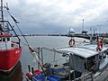
The harbour as seen from the dockside
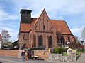
The Fisheries Museum, in the former St Peter and Paul church

Looking roughly north-west along Ulica Wiejska in the centre of Hel
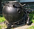
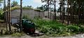
wz. 08/39 naval mine in the open-air museum of naval equipment

Parsons' turbine from the Polish Navy destroyer ORP Wicher


References[]
- ^ "BIP Hel".
- ^ "Wybory samorządowe 2018".
- ^ in other dialects also [hel], [ɦel], [xel], [hil], [ɦil], [xil], [hejl], [ɦejl], [xejl], [hɨl], [ɦɨl], [xɨl].
- ^ Gemeindelexikon für die Provinz Westpreussen: auf Grund der Materialien der Volkszählung vom 1. Dezember 1905 und anderer amtlicher Quellen (Berlin 1908), p.101 f.
- ^ "Marmucommerce chemical information". Archived from the original on 3 January 2012. Retrieved 14 August 2014.
- ^ "Marmucommerce chemical information". Archived from the original on 19 August 2014. Retrieved 14 August 2014.
- ^ "Hel climate: Average Temperature, weather by month, Hel weather averages – Climate-Data.org". en.climate-data.org. Archived from the original on 3 January 2019. Retrieved 27 December 2018.
- ^ "Hel (12135) – WMO Weather Station". National Oceanic and Atmospheric Administration. Retrieved 29 May 2015. Archived 27 December 2018, at the Wayback Machine.
External links[]
| Wikimedia Commons has media related to Hel, Poland. |
| Wikivoyage has a travel guide for Hel. |
- Official website
- "Hela Tavern" – the biggest Hela fan site
- A sailor's guide
- German guns on the Peninsula Hel
| hide | ||
|---|---|---|
| Urban gminas |  | |
| Urban-rural gminas | ||
| Rural gminas | ||

Coordinates: 54°37′N 18°47′E / 54.617°N 18.783°E
| show Authority control |
|---|
- Cities and towns in Pomeranian Voivodeship
- Puck County