Hellerud (station)
 | |
| Location | Hellerud, Oslo Norway |
| Coordinates | 59°54′35″N 10°49′49″E / 59.90972°N 10.83028°ECoordinates: 59°54′35″N 10°49′49″E / 59.90972°N 10.83028°E |
| Elevation | 120.5 m (395 ft) |
| Owned by | Sporveien |
| Operated by | Sporveien T-banen |
| Line(s) | Østensjø Line |
| Distance | 5.5 km (3.4 mi) from Stortinget |
| Construction | |
| Structure type | At-grade |
| Disabled access | Yes |
| History | |
| Opened | 29 October 1967 |

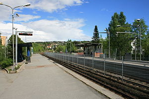
Hellerud is a station on the Oslo Metro system which is shared by two lines, line 2 (the Furuset Line) and line 3 (the Østensjø Line). These two lines diverge immediately east of the station with the eastbound Furuset Line track first diverging southwards before running under the Østensjø Line in order to avoid having the main tracks cross each other. The lines share the same track and platforms. The station is located in a mostly residential area, formerly called the Hellerud borough. Apartment buildings located mainly to the north side of the station.
To the south on the Østensjø Line the next station is Godlia, to the north on the Furuset Line the next station is Tveita, and on the inbound line westwards the next station is Brynseng. The station was opened 29 October 1967 as part of the Østensjø Line, with the line to Furuset coming three years later. Karl Stenersen was the station's architect.[1]
| TERMINUS | NEXT STATION ← WEST |
Hellerud | NEXT STATION EAST → |
TERMINUS | ||
|---|---|---|---|---|---|---|
| Østerås | Brynseng | Line 2 | Tveita | Ellingsrudåsen | ||
| Kolsås | Line 3 | Godlia | Mortensrud | |||
References[]
External links[]
![]() Media related to Hellerud stasjon at Wikimedia Commons
Media related to Hellerud stasjon at Wikimedia Commons
| Lines | |
|---|---|
| Rolling stock | |
| Operators | |
| Stations |
|
| Disused Stations | |
| History | |
- Oslo Metro stations in Oslo
- Railway stations opened in 1967
- 1967 establishments in Norway