Holmen (station)
 | |
| Location | Oslo Norway |
| Coordinates | 59°56′45″N 10°40′01″E / 59.94583°N 10.66694°ECoordinates: 59°56′45″N 10°40′01″E / 59.94583°N 10.66694°E |
| Elevation | 119.4 m (392 ft) |
| Owned by | Sporveien |
| Operated by | Sporveien T-banen |
| Line(s) | Røa Line |
| Distance | 6.1 km (3.8 mi) from Stortinget |
| Construction | |
| Structure type | At-grade |
| Disabled access | Yes |
| History | |
| Opened | 24 January 1935 |

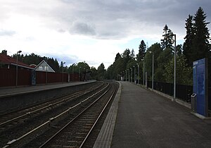
Holmen is a station on the Røa Line (line 2) of the Oslo T-bane system. It is located between Makrellbekken and Hovseter and serves the neighbourhood of Holmen. The station is 6.1 km from Stortinget. Holmen was opened on 24 January 1935 when the line was completed to Røa. The station is at an altitude of 119.4 metres above sea level.[1] The station is located in a mainly residential area.
The Oslo subway system has fought a battle against graffiti, and one of the incidents turned violent on 2 February 2007, when a subway driver was beaten by a vandal.[2]
| TERMINUS | NEXT STATION ← WEST |
Holmen | NEXT STATION EAST → |
TERMINUS | ||
|---|---|---|---|---|---|---|
| Østerås | Hovseter | Line 2 | Makrellbekken | Ellingsrudåsen | ||
References[]
- ^ Subway stations in western Oslo Sporveien.no (in Norwegian)
- ^ Knocked down by taggers Slått ned av taggere, NRK Østlandssendingen, 2 February 2007 (in Norwegian)
External links[]
![]() Media related to Holmen stasjon at Wikimedia Commons
Media related to Holmen stasjon at Wikimedia Commons
Line 2[]
| Line 2: Østerås – Stortinget – Ellingsrudåsen | |
|
Østerås • Lijordet • Eiksmarka • Ekraveien • Røa • Hovseter • Holmen • Makrellbekken • Smestad • Borgen • Majorstuen • Nationaltheatret • Stortinget • Jernbanetorget • Grønland • Tøyen • Ensjø • Helsfyr • Brynseng • Hellerud • Tveita • Haugerud • Trosterud • Lindeberg • Furuset • Ellingsrudåsen | |
| Lines | |
|---|---|
| Rolling stock | |
| Operators | |
| Stations |
|
| Disused Stations | |
| History | |
This article related to the Oslo Metro is a stub. You can help Wikipedia by . |
- Oslo Metro stations in Oslo
- Railway stations opened in 1935
- 1935 establishments in Norway
- Oslo Metro stubs