Hells Canyon Scenic Byway
 | |
|---|---|
| Route information | |
| Maintained by Oregon Department of Transportation, Oregon Parks and Recreation Department, etc. | |
| Length | 218.4 mi[2] (351.5 km) |
| Existed | April 19, 1992[1]–present |
| Major junctions | |
| West end | |
| East end | |
| Location | |
| Counties | Union, Wallowa, Baker |
| Highway system | |
| |
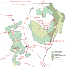
Hells Canyon Scenic Byway is a designated All-American Road in the U.S. state of Oregon. It is located at the northeast corner of Oregon and comprises Oregon Route 82, Forest Roads 39 and 3365, and most of Oregon Route 86. From the west, the byway begins at the intersection of Oregon Route 82 and Interstate 84 near La Grande and ends near Baker City, at the junction of Interstate 84 and Oregon Route 86. It is 218.4 miles (351.5 km) long.[2]
Route description[]
Along its route, Hells Canyon Scenic Byway hugs the Wallowa River, runs through the Wallowa-Whitman National Forest, and goes near Wallowa Lake, , Hells Canyon Overlook and the Eagle Cap Wilderness Area.

History[]
The Hells Canyon Scenic Byway was designated a National Forest Scenic Byway on April 19, 1992. It was later made an Oregon State Scenic Byway on February 19, 1997. The All-American Road designation was applied to the roadway on June 15, 2000.[1]
See also[]
References[]
- ^ a b Staff. "Official Designations". Hells Canyon Scenic Byway. Federal Highway Administration. Retrieved September 11, 2011.
- ^ a b Staff. "Hells Canyon Scenic Byway". National Scenic Byways. Federal Highway Administration. Retrieved May 13, 2008.
External links[]
- All-American Roads
- Scenic highways in Oregon
- National Forest Scenic Byways
- Transportation in Wallowa County, Oregon
- Transportation in Baker County, Oregon
- Transportation in Union County, Oregon
- Tourist attractions in Wallowa County, Oregon
- Tourist attractions in Baker County, Oregon
- Tourist attractions in Union County, Oregon
- Wallowa–Whitman National Forest
- Eagle Cap Wilderness
- 1992 establishments in Oregon