Herekino
Herekino | |
|---|---|
 Herekino Harbour | |
 Herekino | |
| Coordinates: 35°15′53″S 173°12′38″E / 35.26472°S 173.21056°E | |
| Country | New Zealand |
| Region | Northland Region |
| District | Far North District |
| Population (2018) | |
| • Total | 963 |

Herekino is a locality in Northland, New Zealand. It lies 26 km south west of Kaitaia. The Herekino Harbour, also called the Herekino River, is an estuary and inlet from the Tasman Sea to the west. The Herekino Forest, which contains a stand of large kauri, is to the north, and the lies to the north west.[1]
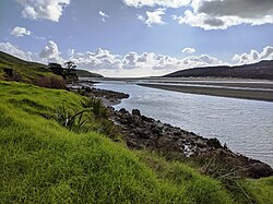
The harbour is mostly above water at high tide, with just a shallow entrance channel. The upper reaches of the harbour contain a mangrove forest.[2] The township of Herekino is at the north east end of the estuary, and the small settlement of Owhata lies on the rocky south shore of the harbour entrance. Owhata is a flat grassy area, with a fairly shallow beach of mud and sand. There is not much natural shelter, and there is a limited supply of fresh water in summer.[3]
Demographics[]
| Year | Pop. | ±% p.a. |
|---|---|---|
| 2006 | 966 | — |
| 2013 | 927 | −0.59% |
| 2018 | 963 | +0.76% |
| Source: [4] | ||
Herekino is part of a statistical area called Herekino-Takahue, which extends well inland of the Herekino locality. Herekino-Takahue had a population of 963 at the 2018 New Zealand census, an increase of 36 people (3.9%) since the 2013 census, and a decrease of 3 people (-0.3%) since the 2006 census. There were 330 households. There were 519 males and 444 females, giving a sex ratio of 1.17 males per female. Of the total population, 222 people (23.1%) were aged up to 15 years, 141 (14.6%) were 15 to 29, 432 (44.9%) were 30 to 64, and 165 (17.1%) were 65 or older. Figures may not add up to the total due to rounding.
Ethnicities were 64.2% European/Pākehā, 52.3% Māori, 4.0% Pacific peoples, 0.9% Asian, and 1.6% other ethnicities. People may identify with more than one ethnicity.
The percentage of people born overseas was 10.6, compared with 27.1% nationally.
Although some people objected to giving their religion, 39.6% had no religion, 41.7% were Christian, and 7.5% had other religions.
Of those at least 15 years old, 90 (12.1%) people had a bachelor or higher degree, and 183 (24.7%) people had no formal qualifications. The median income was $20,600. The employment status of those at least 15 was that 273 (36.8%) people were employed full-time, 138 (18.6%) were part-time, and 45 (6.1%) were unemployed.[4]
History and culture[]
Pre-European history[]
Herekino was named by the Māori chief Tohe, who passed through on the way to visit the local chief Taunaha at Owhata and noticed a lasso-type of bird trap which had been incorrectly tied, which would cause the prey unnecessary suffering. He named the area Herekino-a-Taunaha (the false knot of Taunaha).[5]
Ngāti Ruānui (now Te Aupōuri) dominated the Herekino and Whangape harbours and several battles were fought against other iwi in the area before European settlement.[6]
European settlement[]
In 1846, the brig mistook the Herekino Heads with the entrance to the Hokianga, about 30 km to the south, due to misty weather and the similarity of the two features - both have a northern head formed by sand dunes. The Osprey was driven ashore on the shallow sand bank just north of the headland. No lives were lost. Wreckage is still visible. Herekino was named on some charts as "False Hokianga" due to the similarity of the entrances.[5]
Dalmatian immigrants were growing grapes in Herekino by the late 1890s and by 1906, there were 14 vineyards.[7]
In the mid 1960s Herekino was a small township with shops - a butcher, a petrol station and more. However following the sealing of State Highway 1 through the Mangamuka Gorge to Kaitaia, the township quickly declined.
Marae[]
Herekino has two marae, affiliated with Ngāti Kurī and Te Aupōuri of Te Rarawa:[8] Rangikohu Marae and Ruia te Aroha meeting house; and Manukau Marae and Whakamaharatanga meeting house.[9]
In October 2020, the Government committed $1,407,731 from the Provincial Growth Fund to upgrade the two marae and 7 other Te Rarawa marae, creating 100 jobs.[10]
Education[]

Herekino School is a coeducational full primary (years 1-8) school with a roll of 34 students as of November 2021.[11][12]
Coordinates: 35°15′53″S 173°12′38″E / 35.26472°S 173.21056°E
Notes[]
- ^ "Kaitāia and district". Te Ara: The Encyclopedia of New Zealand.
- ^ "Description of Area: Hokianga, Whangape and Herekino Harbours". Northland Marine Library. Archived from the original on 2008-10-21. Retrieved 2008-01-15.
- ^ Parkes, W. F. (c. 1965). The Visitors' Guide to the Far North - Mangonui County (3rd ed.). p. 14.
- ^ a b "Statistical area 1 dataset for 2018 Census". Statistics New Zealand. March 2020. Herekino-Takahue (101200). 2018 Census place summary: Herekino-Takahue
- ^ a b Parkes, W. F. (c. 1965). The Visitors' Guide to the Far North - Mangonui County (3rd ed.). p. 13.
- ^ "Te Aupōuri and Te Rarawa". Te Ara: The Encyclopedia of New Zealand.
- ^ "Farming, fishing, winemaking". Te Ara: The Encyclopedia of New Zealand.
- ^ "Te Kāhui Māngai directory". tkm.govt.nz. Te Puni Kōkiri.
- ^ "Māori Maps". maorimaps.com. Te Potiki National Trust.
- ^ "Marae Announcements" (Excel). growregions.govt.nz. Provincial Growth Fund. 9 October 2020.
- ^ "New Zealand Schools Directory". New Zealand Ministry of Education. Retrieved 22 December 2021.
- ^ Education Counts: Herekino School
| Wikimedia Commons has media related to Herekino. |
- Far North District
- Ports and harbours of New Zealand
- Populated places in the Northland Region