Hetman National Nature Park
| Hetman National Nature Park | |
|---|---|
| Ukrainian: Гетьманський національний природний парк | |
 Hetman National Nature Park | |
 Location of Park | |
| Location | Trostianets District, Sumy Oblast, |
| Nearest city | Trostianets |
| Coordinates | 50°29′12″N 34°58′59″E / 50.4867°N 34.9831°ECoordinates: 50°29′12″N 34°58′59″E / 50.4867°N 34.9831°E |
| Area | 23,360 hectares (57,724 acres; 234 km2; 90 sq mi) |
| Established | 2009 |
| Governing body | Ministry of Ecology and Natural Resources (Ukraine) |
| Website | http://getmanski.info/index.php/ukr/ |

Hetman National Nature Park (Ukrainian: Гетьманський національний природний парк) is a national park of Ukraine that follows floodplains and terraces of the right bank of the Vorskla River. The park is administrative in Velyka Pysarivka District, Okhtyrka District, and Trostianets District of Sumy Oblast.[1]
Topography[]
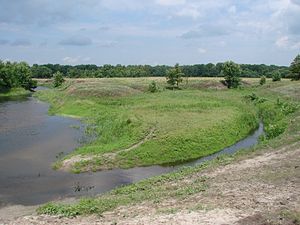
The park begins at the border with Russia as the Vorskla River runs west and south, and follows the river for all 122 km of its length through Sumy Oblast. There are some short breaks between sectors for roads or built-up villages. There terrain is mostly flat, with some hills and ravines.

Climate and ecoregion[]
The climate of the Hetman area is Humid continental climate, warm summer (Köppen climate classification (Dfb)). This climate is characterized by large swings in temperature, both diurnally and seasonally, with mild summers and cold, snowy winters.[2][3]
Hetman is in the East European forest steppe ecoregion, a band of patchy forests and grasslands that stretches from the middle of Ukraine to the Ural Mountains.[4]
Flora and fauna[]
The river valley supports floodplain and terrace wetlands and forest-steppe floral communities. The forest trees are mostly oak, linden, ash, aspen, willow, cherry, birch bark, pine, and birch.[5]
Public use[]
There are hiking trails and guided ecological excursion trails available, and kayaking routes on the river. The park supports educational programs for local school groups, and public education campaigns related to nature preservation.[1]

See also[]
References[]
- ^ Jump up to: a b "Hetman National Nature Park" (in Ukrainian). Official Park Site. Retrieved January 10, 2019.
- ^ Kottek, M., J. Grieser, C. Beck, B. Rudolf, and F. Rubel, 2006. "World Map of Koppen-Geiger Climate Classification Updated" (PDF). Gebrüder Borntraeger 2006. Retrieved September 14, 2019.CS1 maint: multiple names: authors list (link)
- ^ "Dataset - Koppen climate classifications". World Bank. Retrieved September 14, 2019.
- ^ "Map of Ecoregions 2017". Resolve, using WWF data. Retrieved September 14, 2019.
- ^ "Hetman National Nature Park - Ecotours" (in Ukrainian). Official Park Site. Retrieved June 16, 2019.
External links[]
| Wikimedia Commons has media related to Hetmanskyi National Park. |

- IUCN Category II
- National parks of Ukraine