Hibernia, New Jersey
Hibernia, New Jersey | |
|---|---|
Unincorporated community | |
 View along Green Pond Road | |
 Hibernia | |
| Coordinates: 40°56′38″N 74°29′34″W / 40.94389°N 74.49278°WCoordinates: 40°56′38″N 74°29′34″W / 40.94389°N 74.49278°W[1] | |
| Country | |
| State | |
| County | Morris |
| Township | Rockaway |
| Named for | Hibernia, the classical name for Ireland |
| Elevation | 538 ft (164 m) |
| ZIP code | 07866 |
| GNIS feature ID | 877076[1] |


Hibernia is an unincorporated community located along County Route 513 (Green Pond Road) in Rockaway Township of Morris County, New Jersey.[1][2] The area is served as United States Postal Service ZIP code 07842. The community takes its name from Hibernia, the classical name for Ireland.[3]
As of the 2000 United States Census, the population for ZIP Code Tabulation Area 07842 was 93.
The Hibernia mines, a series of iron mines worked from pre-Revolutionary times until 1916, are located here.
Since 1970, the former Methodist Episcopal Church on Green Pond Road has been used as a branch of the Rockaway Township Free Public Library.[4]
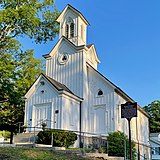
Methodist Episcopal Church, now a library

References[]
- ^ Jump up to: a b c "Hibernia". Geographic Names Information System. United States Geological Survey. Retrieved 2012-09-24.
- ^ "Locality Search". State of New Jersey.
- ^ Gannett, Henry (1905). The Origin of Certain Place Names in the United States. Govt. Print. Off. pp. 156.
- ^ "Library History". Rockaway Township Free Public Library.
External links[]
 Media related to Hibernia, New Jersey at Wikimedia Commons
- "Hibernia Historic District". The Historical Marker Database.
- Census 2000 Fact Sheet for ZIP Code Tabulation Area 07842 from the United States Census Bureau
| show Municipalities and communities of Morris County, New Jersey, United States |
|---|

| show Authority control |
|---|
Categories:
- Rockaway Township, New Jersey
- Unincorporated communities in Morris County, New Jersey
- Unincorporated communities in New Jersey