Ho Man Tin
This article needs additional citations for verification. (August 2021) |
| Ho Man Tin | |||||||||||||||
|---|---|---|---|---|---|---|---|---|---|---|---|---|---|---|---|
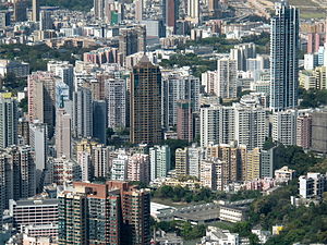 Ho Man Tin Residential | |||||||||||||||
| Chinese | 何文田 | ||||||||||||||
| Cantonese Yale | Hòh màhn tìhn | ||||||||||||||
| |||||||||||||||
| Ho Man Tin | |||||||||
|---|---|---|---|---|---|---|---|---|---|
| Traditional Chinese | 何文田 | ||||||||
| |||||||||


Ho Man Tin is a mostly residential area in Kowloon, Hong Kong, part of the Kowloon City District.
History[]
This section needs additional citations for verification. (March 2019) |
Section of lists of villages in the book Xin'an Xianzhi (literally The History of Xin'an County) published in twenty fourth year of Jiaqing era (A.D. 1819) did not have any record of Ho Man Tin.
The original Ho Man Tin was quite different from today's Ho Man Tin. It was located in the heart of nowaday Mong Kok. With cultivated lands, it was surrounded in the north by Argyle Street, west by Coronation Road (present-day Nathan Road), and east by Quarry Hill, No. 12 Hill and Tai Shek Kwu (present-day Kadoorie Hill). Southeast from its original location is Fo Pang and to the south Mong Kok. Streams from those hills in the east offered water for cultivation, the latter reflected in the area's name last Chinese character, i.e. tin, 田, which means field. The "Ho" (何) and "Man" (文) part of the name are both Chinese surnames; so Ho Man Tin represents the agricultural land owned by the "Ho" and "Man", the major families who took their residence around the area.
In the 1950s and 1960s, the eastern hills to the original site of Ho Man Tin became a resettlement area for refugees from China, the city building there the Ho Man Tin Estate, which gave the name Ho Man Tin to that section of the hills, thus shifting away name-wise from the original flat fields. The present-day Ho Man Tin is close to Argyle Street and Kowloon Hospital. The area is within the district of the .
Today, Ho Man Tin is home to many public housing estates as well as the headquarters of the Housing Authority. Oi Man Estate was on the itinerary of Queen Elizabeth II when she visited Hong Kong in 1975.
Streets and places in Ho Man Tin[]
- Ho Man Tin Hill
- Peace Avenue
- Perth Street
- Princess Margaret Road
- Pui Ching Road
- Soares Avenue
- Victory Avenue
- Waterloo Hill
Community facilities[]
- Perth Street Sports Ground
Public services[]
- Kowloon Public Library
- Kowloon Hospital
- Kowloon Rehabilitation Centre
- Hong Kong Housing Authority Headquarters
Education[]

Educational institutions in Ho Man Tin include:
- The Open University of Hong Kong
- King George V School
- Pentecostal School
- Pui Ching Middle School
- St. Teresa Secondary School
- Workers' Children Secondary School
Transport[]
Princess Margaret Road, Waterloo Road, Argyle Street and act as the main arteries of the Ho Man Tin area, and it is conveniently served by public buses.
Despite the name, Ho Man Tin station of the Mass Transit Railway (MTR) is not located in Ho Man Tin proper but in the lesser known area Lo Lung Hang instead. The central part of Ho Man Tin between Argyle Street and Waterloo Road is in fact more than 1 km (0.62 mi) away on foot. This led to a debate on its naming circa the station's opening.[1][2]
See also[]
References[]
- ^ 搜查線:何文田站唔喺何文田?80後誓保地名. Oriental Daily News. 4 November 2016.
- ^ "The very Hong Kong reason why nine in ten MTR station names are actually inaccurate". South China Morning Post. 2 October 2017.
External links[]
| Wikimedia Commons has media related to Ho Man Tin. |

- Ho Man Tin