Hochfeiler
| Hochfeiler | |
|---|---|
 | |
| Highest point | |
| Elevation | 3,510 m (11,520 ft) |
| Prominence | 981[1] |
| Isolation | 49.3 km (30.6 mi) |
| Listing | Alpine mountains above 3000 m |
| Coordinates | 46°58′22″N 11°43′34″E / 46.97278°N 11.72611°ECoordinates: 46°58′22″N 11°43′34″E / 46.97278°N 11.72611°E |
| Geography | |
 Hochfeiler Location in the Alps | |
| Location | Tyrol, Austria / South Tyrol, Italy |
| Parent range | Zillertal Alps |
| Climbing | |
| First ascent | 24 July 1865 by Paul Grohmann, Georg Samer and Peter Fuchs |


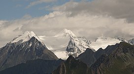
The Hochfeiler (Italian: Gran Pilastro; German: Hochfeiler) is a mountain, 3,510 metres high, and the highest peak in the Zillertal Alps on the border between Tyrol, Austria, and South Tyrol, Italy.
References[]
- ^ "Hochveiler - Peakbagger". Peakbagger.com. Retrieved 14 May 2020.
- Heinrich Klier, Walter Klier: Alpine Club Guide Zillertaler Alpen, Rother Verlag, Munich, (1996), ISBN 3-7633-1269-2
- Zeitschrift des Oesterreichischen Alpenvereins, Vol. II, page 127, Vienna, 1870/71
- Carl Diener in Eduard Richter (ed.): Die Erschließung der Ostalpen, Vol. III, Berlin, 1894
- Raimund von Klebelsberg: Geologie von Tirol, Berlin, 1935
- Alpine Club Map 1:25,000 series, Sheet 35/1
- Tabacco-Verlag, Udine, carta topografica 1:25,000, Sheet 037, Hochfeiler-Pfunderer Berge
External links[]
![]() Media related to Hochfeiler at Wikimedia Commons
Media related to Hochfeiler at Wikimedia Commons
This Tyrol location article is a stub. You can help Wikipedia by . |
Categories:
- Mountains of the Alps
- Mountains of Tyrol (state)
- Mountains of South Tyrol
- Alpine three-thousanders
- Zillertal Alps
- Austria–Italy border
- International mountains of Europe
- Tyrol geography stubs