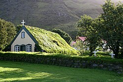
Hof, Iceland
Hof | |
|---|---|
 Wood and turf church at Hof. | |
 Hof Location in Iceland | |
| Coordinates: 63°54′24″N 16°42′26″W / 63.90667°N 16.70722°WCoordinates: 63°54′24″N 16°42′26″W / 63.90667°N 16.70722°W | |
| Country | |
| Constituency | South |
| Region | Eastern Region |
| County | Austur-Skaftafellssýsla |
| Municipality | Sveitarfélagið Hornafjörður |
| Elevation | 300 ft (100 m) |
| Time zone | UTC+0 (GMT) |
| Post Code | 785 |
Hof, (Icelandic pronunciation: [ˈhɔːf]) in Öræfi, is a cluster of farms in the municipality of Sveitarfélagið Hornafjörður in southeast Iceland, close to Vatnajökull glacier, and twenty two kilometres south of Skaftafell in Vatnajökull National Park. It is on the Route 1 southwest of Höfn, in the narrow strip between the sea coast and the glacier.
It is 9.14 km WSW of the centre of Öræfajökull volcano.
A notable building in Hof is a turf church, which was built in 1883 and is the youngest turf church in Iceland. Since 1951, it belongs to the National Museum of Iceland.[1]
References[]
![]() Media related to Hof í Öræfum at Wikimedia Commons
Media related to Hof í Öræfum at Wikimedia Commons
- ^ Iceland Road Guide (12th ed.). Reykjavik: Vegahandbokin. 2011. p. 120. ISBN 9789979999225.
Categories:
- Populated places in Eastern Region (Iceland)
- Iceland geography stubs
