Höfn
Sveitarfélagið Hornafjörður | |
|---|---|
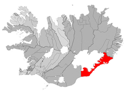 Location of Sveitarfélagið Hornafjörður | |
 Sveitarfélagið Hornafjörður Location of Sveitarfélagið Hornafjörður | |
| Coordinates: Coordinates: 64°15′14″N 15°12′43″W / 64.254°N 15.212°W | |
| Country | Iceland |
| Region | Eastern Region |
| Constituency | South Constituency |
| Government | |
| • Mayor | Matthildur Ásmundardóttir |
| Area | |
| • Total | 6,280 km2 (2,420 sq mi) |
| Population | |
| • Total | 2,462 |
| • Density | 0.35/km2 (0.9/sq mi) |
| Postal code(s) | 780, 781, 785 |
| Municipal number | 7708 |
| Website | hornafjordur |

Höfn (Icelandic pronunciation: [ˈhœpn̥]) or Höfn í Hornafirði ([ˈhœpn i ˈhɔ(r)tnaˌfɪrðɪ]) is an Icelandic fishing town in the southeastern part of the country. It lies near Hornafjörður fjord.
The town, the second largest in the southeastern part of Iceland, offers scenic views of Vatnajökull (the largest ice cap in Europe by volume). The community was formerly known as Hornafjarðarbær between 1994 and 1998.[1][2][3][4]
Geography[]
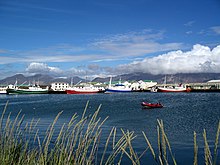

Höfn is located on a peninsula in the southeast of Iceland. The name Höfn means harbour and it is a fishing port surrounded on three sides by the sea, with beaches on a long shoreline to the southeast. Shoals and glacial rivers traverse this area with many shifting lagoons and sand reefs being formed. Höfn is surrounded by several small islands to the east of the town, the largest of which is , followed by and .
Höfn is one of very few harbours in the southern part of Iceland and it needs to be navigated with care due to the changing pattern of shoals. Dredging is an essential requirement to remove sand that has accumulated near the harbour so that ships can safely moor.[5] The entrance channel to Höfn port has a minimum depth of 6–7 metres (20–23 ft). However, the depth at the entrance itself is 7–8 metres (23–26 ft). The harbour at Höfn is reported to freeze during periods of extremely cold weather.[6]
Eagle Airways operates domestic flights from Höfn airport[3] and the town is a major centre for visitors to the Vatnajökull Glacier.[5] Höfn lies at the end of Road 99, which leaves Iceland's National Road 1 several kilometres north of the town. A tunnel is located near the town, measuring 1,300 metres in length, which is named Almannaskarðsgöng. It was opened in 2005.
Nearby areas include Suðursveit (the birthplace of Þórbergur Þórðarson), Öræfasveit, , and . In Nes there is a small village called Nesjahverfi. Reykjavík, the capital of Iceland, is about 458 kilometres (285 mi) from Höfn along the south coast.[4]
Economy[]

The main economic activities in Höfn are fishing and tourism. Fishing involves both sea fishing and processing and packaging in the factories; one major fish processing factory, Skinney-Þinganes is one of the largest fish factories in the eastern part of Iceland, which employs a large number of people. The main production of these factories is bacaloa (saltfish) and processed lobster. Herring and capelin are also processed. Ten large and a number of smaller boats operate from Höfn.[3] During the summer tourist season, trips are organised to the nearby Vatnajökull glacier. The surrounding area has served as a filming location for feature films including the James Bond movies Die Another Day and A View to a Kill, Lara Croft: Tomb Raider, and Batman Begins.[3] Recently a song in the 2015 Bollywood movie "Dilwale" has been shot in the surrounding areas.[7]
Höfn offers a variety of services and stores including a supermarket, pharmacy, a bank, three hairdressers, two gas stations and a swimming pool.
In the town there are several guesthouses and restaurants. Restaurants including Pakkhúsið, Humarhöfnin, Íshúsið Pizzeria, Ottó, Kaffihornið, Ósinn, Z Bistro and Hafnarbúðin.
The headland of the town is called the Ingólfshöfði, which is 76 metres (249 ft) high and 85 kilometres (53 mi) (in a direct line) from the town. Sea birds such as skuas, guillemots, fulmar and puffins can be seen from the headland.[8]
Culture[]
A cultural highlight of the town is the annual Humarhátíð (a lobster festival) held on the first weekend of July. During the summer season, the Glacier Exhibition is held in the old supermarket building.[4]
Höfn contains several museums, including an exhibition about the Vatnajökulsþjóðgarð in Gamlabúð which has a variety of displays on the geology, ecology and history of the glacier.
Gamlabúð[]
Gamlabúð ("Old Shop") is one of the oldest houses in Höfn still being used. It has served at least three purposes and has been moved around southeast Iceland. First it was a trade center in Papós and then it was a store in Höfn. Most recently it has been moved again and now it serves as an information center.[9]
Originally called "Krambúðin", meaning "The Mercantile Store", in a short time it had managed to become one of the main trade centers for the people of southeast Iceland, as there were few other settlements in the area. Just about everything available in these parts of Iceland was sold here. Farmers were the main group of people making purchases, so naturally it sold mostly tools and such things that farmers needed on daily basis. In 1897 it was moved to the harbor of Höfn and stayed there for 80 years.[10]
The house was the main trade post for the citizens of Höfn from 1937-1977, but when the town began to develop and modernize, the shop had neither a place at the harbor or in the town so it changed and moved, this time to Sílavík on the outskirts of town.[11]
The municipality decided to move it again in 2012, back to the harbour of Höfn.[12] This was done with the blessing of The Cultural Heritage Agency of Iceland which oversees the conservation of historical buildings.[13] It now serves as an information and visitor centre for Vatnajökull National Park.[14]
Education[]
Höfn used to have three schools: , located in Nesjahverfi, and . Now, the three schools have been merged into one school called Grunnskóli Hornafjarðar. In the secondary school Framhaldsskólinn í Austur-Skaftafellssýslu 70 to 100 students study in the day school and over 100 students are under distance-study programmes. The school maintains close collaboration with other schools in Iceland, the College in Egilsstaðir and the Vocational School in Neskaupstaður. The school has modern teaching facilities such as wireless internet, a computer centre, availability of laptop computers for students, overhead projectors and built-in sound systems.[3]

Sports[]
The local football club is Sindri, which plays in the Icelandic 3rd tier.
Climate[]
Höfn has a subpolar oceanic climate (Köppen Cfc), bordering on a subarctic climate and tundra climate. Daytime highs in the summer are around 12 °C (54 °F), while being just above the freezing point in the winter. Höfn is a rainy town, averaging approximately 1,450 mm (57 in) of precipitation. On average, Höfn has 180 days with measurable precipitation. Extreme temperatures range from 24.4 °C (76 °F) recorded on August 10, 2004 to −21.6 °C (−7 °F) recorded on March 8, 1969.[15]
| hideClimate data for Hólar í Hornafirði (1961-1990) | |||||||||||||
|---|---|---|---|---|---|---|---|---|---|---|---|---|---|
| Month | Jan | Feb | Mar | Apr | May | Jun | Jul | Aug | Sep | Oct | Nov | Dec | Year |
| Record high °C (°F) | 15.8 (60.4) |
13.6 (56.5) |
15.2 (59.4) |
18.0 (64.4) |
20.8 (69.4) |
23.6 (74.5) |
24.2 (75.6) |
24.4 (75.9) |
19.0 (66.2) |
17.0 (62.6) |
17.6 (63.7) |
12.0 (53.6) |
24.4 (75.9) |
| Average high °C (°F) | 2.5 (36.5) |
2.9 (37.2) |
3.5 (38.3) |
5.7 (42.3) |
8.5 (47.3) |
11.0 (51.8) |
12.6 (54.7) |
12.2 (54.0) |
9.9 (49.8) |
7.0 (44.6) |
3.7 (38.7) |
2.7 (36.9) |
6.8 (44.2) |
| Daily mean °C (°F) | 0.1 (32.2) |
0.7 (33.3) |
1.0 (33.8) |
3.1 (37.6) |
6.0 (42.8) |
8.6 (47.5) |
10.2 (50.4) |
9.8 (49.6) |
7.5 (45.5) |
4.8 (40.6) |
1.5 (34.7) |
0.0 (32.0) |
4.4 (39.9) |
| Average low °C (°F) | −2.5 (27.5) |
−2.0 (28.4) |
−1.8 (28.8) |
0.3 (32.5) |
3.2 (37.8) |
6.1 (43.0) |
7.7 (45.9) |
7.3 (45.1) |
4.7 (40.5) |
2.2 (36.0) |
−1.2 (29.8) |
−2.7 (27.1) |
1.8 (35.2) |
| Record low °C (°F) | −16.4 (2.5) |
−17.4 (0.7) |
−21.6 (−6.9) |
−17.2 (1.0) |
−8.2 (17.2) |
−1.2 (29.8) |
2.0 (35.6) |
0.5 (32.9) |
−3.4 (25.9) |
−10.0 (14.0) |
−12.2 (10.0) |
−16.4 (2.5) |
−21.6 (−6.9) |
| Average precipitation mm (inches) | 164.2 (6.46) |
130.2 (5.13) |
121.2 (4.77) |
94.8 (3.73) |
95.7 (3.77) |
88.8 (3.50) |
84.4 (3.32) |
110.7 (4.36) |
119.0 (4.69) |
183.1 (7.21) |
116.8 (4.60) |
145.9 (5.74) |
1,452.6 (57.19) |
| Average precipitation days (≥ 0.1 mm) | 17.1 | 14.1 | 15.5 | 12.9 | 12.7 | 13.8 | 14.9 | 15.4 | 15.3 | 17.3 | 14.0 | 16.1 | 179.3 |
| Mean monthly sunshine hours | 25.6 | 62.1 | 116.9 | 142.3 | 172.6 | 147.0 | 141.1 | 130.3 | 114.8 | 78.6 | 47.4 | 16.8 | 1,195.5 |
| Source: Icelandic Met Office[16][17] | |||||||||||||
Transport[]

Höfn is well connected via Route 1, which circles Iceland. The distance to Reykjavik is 455 km (283 mi). In the past, during the harsh winter months, the road just east of Höfn would often become blocked because of regular snow, hampering communications and access. To address this, a new tunnel, named Almannaskarðsgöng, was constructed and opened in 2005. The tunnel measures exactly 1,312 metres (4,304 feet) in length (although the sign rounds it off to 1,300).
By air, Hornafjörður Airport provides service to Reykjavik.
References[]
- ^ Evans, Andrew (2008). Iceland. Bradt Travel Guides. pp. 384–385. ISBN 978-1-84162-215-6. Retrieved 2010-11-02.
- ^ Parnell, Fran; Etain O'Carroll (2007). Iceland. Lonely Planet. pp. 291–292. ISBN 978-1-74104-537-6. Retrieved 2010-11-02.
- ^ Jump up to: a b c d e "Höfn í Hornafirði". Water and Fire. Retrieved 2010-11-03.
- ^ Jump up to: a b c "Hofn – Hornafjordur". NAT Nordic Adventure Travel. Archived from the original on June 27, 2003. Retrieved 2010-11-03.
- ^ Jump up to: a b Young, Don; Marjorie Young (2008). ravel Adventures Iceland. Hunter Publishing, Inc. pp. 325–327. ISBN 978-1-58843-672-6. Retrieved 2010-11-02.
- ^ G. J Dodd, G. P Benson and D. T Watts (1996). Arctic pilot: Volume 2. Hydrographer of the Navy. p. 127. Retrieved 2010-11-02.CS1 maint: uses authors parameter (link)
- ^ http://icelandreview.com/de/node/82549
- ^ Harding, Paul; Mark Elliott (2007). Scandinavian Europe. Lonely Planet. p. 268. ISBN 978-1-74104-553-6. Retrieved 2010-11-02.
- ^ Author unknown. Hornafjörður Cultural Centre. Retrieved 28.2.2013 from "Archived copy". Archived from the original on 2012-01-30. Retrieved 2013-05-09.CS1 maint: archived copy as title (link)
- ^ Björnsson, S, Bjarnason, B and Björnsson, G. (1976). Byggðarsaga Austur-Skaftafellssýslu. Reykjavík: Bókaútgáfa Guðjónson
- ^ Björnsson, S, Bjarnason, B and Björnsson, G. (1976). Byggðarsaga Austur-Skaftafellssýslu. Reykjavík: Bókaútgáfa Guðjónsson
- ^ Hornafjörður Cultural Centre. (2007). Stefnumótun í menningar– og safnamálum Hornafjarðar 2007-2017. Retrieved from: "Archived copy" (PDF). Archived from the original (PDF) on 2014-02-01. Retrieved 2013-05-09.CS1 maint: archived copy as title (link)
- ^ "Archived copy". Archived from the original on 2013-06-16. Retrieved 2013-05-09.CS1 maint: archived copy as title (link)
- ^ "A new Information Centre in Höfn". Vatnajökull national park. Archived from the original on 3 February 2014. Retrieved 31 January 2014.
- ^ "Hólar í Hornafirði Annual Averages and Extreme Temperatures". Icelandic Meteorological Office. Archived from the original on 6 February 2018. Retrieved 2 May 2016.
- ^ "Hólar í Hornafirði 1961-1990 Averages". Icelandic Meteorological Office. Archived from the original on 7 October 2016. Retrieved 3 May 2016.
- ^ "Climatological Data for Hólar í Hornafirði". Icelandic Met Office. Archived from the original on 6 February 2018. Retrieved 21 June 2016.
External links[]
| Wikimedia Commons has media related to Höfn. |
![]() Höfn travel guide from Wikivoyage
Höfn travel guide from Wikivoyage

| Authority control |
|---|
- Municipalities of Iceland
- Populated places in Southern Region (Iceland)
- Fishing communities in Iceland