Húnavatnshreppur
This article does not cite any sources. (June 2017) |
Húnavatnshreppur | |
|---|---|
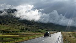 Skyline of Húnavatnshreppur | |
 Coat of arms | |
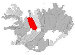 Location of the municipality | |
 Húnavatnshreppur Location of the municipality | |
| Coordinates: 65°30′57″N 20°23′18″W / 65.5158316°N 20.3883425°WCoordinates: 65°30′57″N 20°23′18″W / 65.5158316°N 20.3883425°W | |
| Country | Iceland |
| Region | Northwestern Region |
| Constituency | Northwest Constituency |
| Government | |
| • Manager | Einar Kristján Jónsson |
| Area | |
| • Total | 3,817 km2 (1,474 sq mi) |
| Population | |
| • Total | 409 |
| • Density | 0.11/km2 (0.3/sq mi) |
| Municipal number | 5612 |
| Website | hunavatnshreppur |

Húnavatnshreppur (Icelandic pronunciation: [ˈhuːnaˌvasːˌr��ɛhpʏr̥]) is a rural municipality located in north-western Iceland.
History[]
The municipality was formed on 1 January 2006 by the union of the former municipalities of , , and .
Geography[]
Húnavatn is one of the largest Icelandic municipalities. Its southern borders touch the glaciers of Hofsjökull and Langjökull. In the south are situated also the hot springs in Hveravellir.
References[]
External links[]
| Authority control |
|
|---|
This Iceland location article is a stub. You can help Wikipedia by . |
Categories:
- Municipalities of Iceland
- Northwestern Region (Iceland)
- Iceland geography stubs