Fljótsdalshérað
Fljótsdalshérað | |
|---|---|
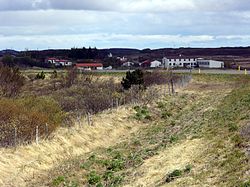 Skyline of Fljótsdalshérað | |
 Location of the municipality | |
 Fljótsdalshérað Location of the municipality | |
| Coordinates: 65°15′50″N 14°23′42″W / 65.264°N 14.395°WCoordinates: 65°15′50″N 14°23′42″W / 65.264°N 14.395°W | |
| Country | Iceland |
| Region | Eastern Region |
| Constituency | Northeast Constituency |
| Government | |
| • Mayor | Björn Ingimarsson |
| Area | |
| • Total | 8,884 km2 (3,430 sq mi) |
| Population (2018) | |
| • Total | 3,580 |
| • Density | 0.40/km2 (1.0/sq mi) |
| Postal code(s) | 700, 701 |
| Municipal number | 7620 |
| Website | egilsstadir |

Fljótsdalshérað (Icelandic pronunciation: [ˈfljoutsˌtalsˌçɛːraθ]) is a municipality located in eastern Iceland. It is the largest municipality in the country by area. The biggest town in the municipality is Egilsstaðir, with a population of 2,300.
The feral reindeer of Iceland are mostly situated in Fljótsdalshérað, where they have a number of between 5,000 and 10,000. The largest forest in Iceland, Hallormsstaðaskógur is also located in Fljótsdalshérað.
The Kárahnjúkar Hydropower Plant is located in the municipality.
Twin towns – sister cities[]
Fljótsdalshérað is twinned with:[1]
References[]
- ^ "Vinabæir". fljotsdalsherad.is (in Icelandic). Fljótsdalshérað. Retrieved 2020-02-12.
| show Authority control |
|---|
This Iceland location article is a stub. You can help Wikipedia by . |
Categories:
- Municipalities of Iceland
- Eastern Region (Iceland)
- Iceland geography stubs