Hofors Municipality
Hofors Municipality
Hofors kommun | |
|---|---|
 | |
 Coat of arms | |
 | |
| Coordinates: 60°33′N 16°17′E / 60.550°N 16.283°ECoordinates: 60°33′N 16°17′E / 60.550°N 16.283°E | |
| Country | Sweden |
| County | Gävleborg County |
| Seat | Hofors |
| Area | |
| • Total | 445.71 km2 (172.09 sq mi) |
| • Land | 409.94 km2 (158.28 sq mi) |
| • Water | 35.77 km2 (13.81 sq mi) |
| Area as of 1 January 2014. | |
| Population (31 December 2019)[2] | |
| • Total | 9,588 |
| • Density | 22/km2 (56/sq mi) |
| Time zone | UTC+1 (CET) |
| • Summer (DST) | UTC+2 (CEST) |
| ISO 3166 code | SE |
| Province | Gästrikland |
| Municipal code | 2104 |
| Website | www.hofors.se |

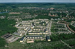
Hofors Municipality (Hofors kommun) is a municipality in Gävleborg County, east central Sweden. Its seat is in Hofors with 7,400 inhabitants, situated at 60°33′N 16°17′E / 60.550°N 16.283°E.
The first municipality with the name of Hofors was broken away from Torsåker in 1925. In 1971 the two entities were reunited to form the present municipality.
The coat of arms stem from 1968, and is derived from a map from 1539, where the town Hofors was surrounded by iron mines. ([1]).
Geography[]
Nearest cities are Gävle, 50 kilometers away, and Falun, 30 kilometers away.
Localities[]
Sister cities[]
Two sister cities:
- Denmark: Fladså,
- Finland: Kontiolahti
Until recently, Tokke in Norway was a sister city, but it has for some reason been discontinued. (Source: [2])
References[]
- ^ "Statistiska centralbyrån, Kommunarealer den 1 januari 2014" (in Swedish). Statistics Sweden. 2014-01-01. Archived from the original (Microsoft Excel) on 2016-09-27. Retrieved 2014-04-18.
- ^ "Folkmängd i riket, län och kommuner 31 december 2019" (in Swedish). Statistics Sweden. February 20, 2020. Retrieved February 20, 2020.
External links[]
 Media related to Hofors Municipality at Wikimedia Commons
Places adjacent to Hofors Municipality | |
|---|---|
Municipalities and seats of Gävleborg County | ||
|---|---|---|
| Municipalities | ||
| Municipal seats | ||
This article about a location in Gävleborg County, Sweden is a stub. You can help Wikipedia by . |
- Municipalities of Gävleborg County
- Gävleborg County geography stubs