Holtemme
This article does not cite any sources. (September 2020) |
| Holtemme | |
|---|---|
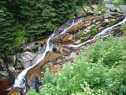 The Steinerne Renne on the upper reaches of the Holtemme | |
| Location | |
| Country | Germany |
| State | Saxony-Anhalt |
| Physical characteristics | |
| Source | |
| • location | on the northeastern slopes of the Renneckenberg in the Harz |
| • elevation | 840 m above sea level (HN) |
| Mouth | |
• location | near into the Bode |
• coordinates | 51°57′49″N 11°10′59″E / 51.963532°N 11.183074°E |
• elevation | 97 m above sea level (HN) |
| Length | 47 km (29 mi) |
| Basin size | 271 km2 (105 sq mi) |
| Basin features | |
| Progression | Bode→ Saale→ Elbe→ North Sea |
| Landmarks |
|

The Holtemme is a 47-kilometre (29 mi) long tributary of the river Bode in Saxony-Anhalt, Germany.
It rises in the Harz mountains at the eastern foot of the Brocken, descends during its upper course as the Steinerne Renne, a steep stream bed riddled with granite rocks, flows through Hasserode, Wernigerode and past their villages of Minsleben and Silstedt, through Derenburg and Halberstadt and discharges into the Bode.
In Wernigerode, not far from the western gate, the Zillierbach, which is also known as the Flutrenne, merges into the Holtemme.
| Authority control |
|---|
Categories:
- Tributaries of the Bode
- Rivers of Saxony-Anhalt
- Rivers of the Harz
- Rivers of Germany
- Saxony-Anhalt river stubs