Huánuco
This article includes a list of general references, but it remains largely unverified because it lacks sufficient corresponding inline citations. (May 2009) |
Huánuco
Wanuku Caballeros del León de Huánuco | |
|---|---|
 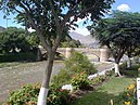 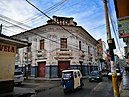 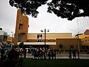  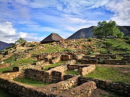 Top:San Sebastian Church and Huancuo San Sebastian Park, Second:Calicaoto Bridge and Huallagu River, A street of July 28 Merced Passage of Huancuo, Third:Huancuo Carthedral and Almas Square, Huancuo Saint Domingo Park, Bottom:Kotosh Ruin and Kotosh Temple of the Crossed Hands (all item of left to right) | |
 Flag  Coat of arms | |
 Huánuco | |
| Coordinates: 9°55′46.07″S 76°14′22.97″W / 9.9294639°S 76.2397139°W | |
| Country | |
| Region | Huánuco |
| Province | Huánuco |
| Founded | 15 August 1539 |
| Founded by | Gómez de Alvarado y Contreras |
| Government | |
| • Mayor | José Luis Villavicencio Guardia (2019-2022) |
| Elevation | 1,880 m (6,170 ft) |
| Population (2017) | |
| • Total | 196,627 |
| • Estimate (2015)[1] | 175,068 |
| Demonym(s) | huanuqueño/a |
| Time zone | UTC-5 (PET) |


Huánuco (Spanish pronunciation: [ˈwanuko]; Quechua: Wanuku) is a city in central Peru. It had a population of 196,627 as of 2017[2] and in 2015 it had a population of 175,068. It is the capital of the Huánuco Region and the Huánuco District. It is the seat of the diocese of Huánuco. The metropolitan city of Huanuco is 170,000 hab (2011, urban pop, INEI). It has three districts, Huanuco (head), Amarilis, and Pillco Marca. In this city, the Higueras river meets the Huallaga river, one of the largest rivers in the country.
History[]
The city of Huánuco was founded by Spanish conquistador Gómez de Alvarado in 1539, in the Inca town of Yarowilca. In 1541, the city was moved to its current location in the Pillco Valley.
Geography[]
Climate[]
Huánuco has a mild semi-arid climate (Köppen BSh). The temperatures are pleasant throughout the year with very warm days and comfortable nights due to its elevation of 1,913 metres or 6,276 feet.
| hideClimate data for Huánuco (1961-1990) | |||||||||||||
|---|---|---|---|---|---|---|---|---|---|---|---|---|---|
| Month | Jan | Feb | Mar | Apr | May | Jun | Jul | Aug | Sep | Oct | Nov | Dec | Year |
| Average high °C (°F) | 26.4 (79.5) |
25.8 (78.4) |
26.0 (78.8) |
26.5 (79.7) |
26.7 (80.1) |
25.9 (78.6) |
25.6 (78.1) |
26.3 (79.3) |
26.7 (80.1) |
27.1 (80.8) |
27.2 (81.0) |
26.9 (80.4) |
26.4 (79.5) |
| Average low °C (°F) | 13.6 (56.5) |
13.6 (56.5) |
13.5 (56.3) |
12.9 (55.2) |
12.0 (53.6) |
10.0 (50.0) |
9.2 (48.6) |
10.6 (51.1) |
12.2 (54.0) |
13.2 (55.8) |
13.8 (56.8) |
13.8 (56.8) |
12.4 (54.3) |
| Average rainfall mm (inches) | 47.5 (1.87) |
64.0 (2.52) |
62.6 (2.46) |
26.5 (1.04) |
9.4 (0.37) |
3.7 (0.15) |
3.8 (0.15) |
6.0 (0.24) |
13.8 (0.54) |
30.3 (1.19) |
41.9 (1.65) |
44.1 (1.74) |
353.6 (13.92) |
| Source: NOAA[3] | |||||||||||||
Education[]
Schools[]
Universities[]
Notable people[]
- Mariano Ignacio Prado - President and General, born in 1825.
- Leoncio Prado - Colonel and hero; fought in Cuba and against the Chilean invasion after The War of the Pacific.
- - Famous geographer, born in Panao Province.
- Daniel Alomía Robles - Musical composer and ethnologist born in 1871, famous for El Cóndor Pasa
- Johan Fano- Professional football player
Transportation[]
It is served by the Alférez FAP David Figueroa Fernandini Airport. One of the main highways of the country passes by Huanuco, communicating Lima-Callao with Tingo Maria and Pucallpa in the Peruvian Amazonia.
See also[]
- Administrative divisions of Peru
- Killa Rumi
Notes[]
- ^ Perú: Población estimada al 30 de junio y tasa de crecimiento de las ciudades capitales, por departamento, 2011 y 2015. Perú: Estimaciones y proyecciones de población total por sexo de las principales ciudades, 2012-2015 (Report). Instituto Nacional de Estadística e Informática. March 2012. Retrieved 3 June 2015.
- ^ "74.774 according to 2007 census: see". Archived from the original on 5 June 2010. Retrieved 3 April 2010.
- ^ "Huánuco Climate Normals 1961-1990". National Oceanic and Atmospheric Administration. Retrieved 23 April 2015.
External links[]
| Wikimedia Commons has media related to Huánuco. |
Coordinates: 9°55′46.07″S 76°14′22.97″W / 9.9294639°S 76.2397139°W
| show Authority control |
|---|
- Populated places in the Huánuco Region
- Populated places established in 1539
- Cities in Peru
- 1539 establishments in the Spanish Empire
- Regional capital cities in Peru