Huerfano River
| Huerfano River[1] | |
|---|---|
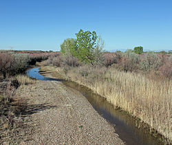 The river just before it goes under U.S. Highway 50 in Pueblo County. | |
| Physical characteristics | |
| Source | |
| • coordinates | 37°35′50″N 105°29′40″W / 37.59722°N 105.49444°W |
| Mouth | |
• location | Confluence with Arkansas |
• coordinates | 38°13′43″N 104°14′45″W / 38.22861°N 104.24583°WCoordinates: 38°13′43″N 104°14′45″W / 38.22861°N 104.24583°W |
• elevation | 4,442 ft (1,354 m) |
| Discharge | |
| • location | Boone, Colorado |
| • average | 31 cu/ft. per sec.[2] |
| Basin features | |
| Progression | Arkansas—Mississippi |

Huerfano River is a 113-mile-long (182 km)[3] tributary of the Arkansas River that flows from a source on Blanca Peak in the Sangre de Cristo Mountains of Colorado. It joins the Arkansas in Pueblo County just south of the town of Boone. One major tributary is the Cucharas River.
The Huerfano River was named after the nearby Huerfano Butte.[4] Huerfano is derived from a Spanish name meaning "orphan", so named from the butte's remote location.[5]
See also[]
References[]
- ^ "Huerfano River". Geographic Names Information System. United States Geological Survey. Retrieved 2011-01-30.
- ^ https://waterdata.usgs.gov/co/nwis/uv/?site_no=07116500&PARAmeter_cd=00065,00060
- ^ U.S. Geological Survey. National Hydrography Dataset high-resolution flowline data. The National Map Archived 2012-04-05 at WebCite, accessed March 31, 2011
- ^ Dawson, John Frank. Place names in Colorado: why 700 communities were so named, 150 of Spanish or Indian origin. Denver, CO: The J. Frank Dawson Publishing Co. p. 27.
- ^ Gannett, Henry (1905). The Origin of Certain Place Names in the United States. Govt. Print. Off. pp. 162.
| hide Authority control | |
|---|---|
| National libraries | |
| Other | |
This article related to a river in Colorado is a stub. You can help Wikipedia by . |
Categories:
- Rivers of Colorado
- Tributaries of the Arkansas River
- Rivers of Huerfano County, Colorado
- Rivers of Pueblo County, Colorado
- Colorado river stubs