Pueblo County, Colorado
Pueblo County | |
|---|---|
U.S. county | |
 The Pueblo County Courthouse with brass dome in Pueblo | |
 Seal | |
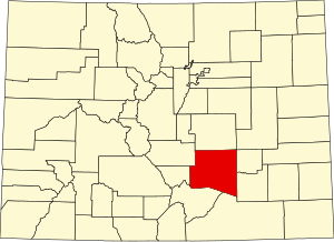 Location within the U.S. state of Colorado | |
 Colorado's location within the U.S. | |
| Coordinates: 38°09′N 104°31′W / 38.15°N 104.51°W | |
| Country | |
| State | |
| Founded | November 1, 1861 |
| Named for | City of Pueblo |
| Seat | Pueblo |
| Largest city | Pueblo |
| Area | |
| • Total | 2,398 sq mi (6,210 km2) |
| • Land | 2,386 sq mi (6,180 km2) |
| • Water | 12 sq mi (30 km2) 0.5%% |
| Population | |
| • Estimate (2019) | 168,424 |
| • Density | 70.21/sq mi (27.11/km2) |
| Time zone | UTC−7 (Mountain) |
| • Summer (DST) | UTC−6 (MDT) |
| Congressional district | 3rd |
| Website | www |

Pueblo County (/ˈpwɛbloʊ/ or /ˈpjɛbloʊ/) is a county located in the U.S. state of Colorado. As of the 2010 census, the population was 159,063.[1] The county seat is Pueblo.[2] The county was named for the historic city of Pueblo which took its name from the Spanish language word meaning "town" or "village". Pueblo County comprises the Pueblo, CO Metropolitan Statistical Area.[3][4]
Geography[]
According to the U.S. Census Bureau, the county has a total area of 2,398 square miles (6,210 km2), of which 2,386 square miles (6,180 km2) is land and 12 square miles (31 km2) (0.5%) is water.[5]
Adjacent counties[]
- El Paso County - north
- Lincoln County - northeast
- Crowley County - east
- Otero County - east
- Las Animas County - south
- Huerfano County - southwest
- Custer County - west
- Fremont County - northwest
Major Highways[]
 Interstate 25
 U.S. Highway 50
 U.S. Highway 85
 State Highway 10
 State Highway 45
 State Highway 47
 State Highway 78
 State Highway 96
 State Highway 120
 State Highway 165
 State Highway 167
National protected areas[]
Trails and byways[]
- American Discovery Trail
- Frontier Pathways National Scenic and Historic Byway
- TransAmerica Trail Bicycle Route
- Western Express Bicycle Route
Demographics[]
| Historical population | |||
|---|---|---|---|
| Census | Pop. | %± | |
| 1870 | 2,265 | — | |
| 1880 | 7,167 | 216.4% | |
| 1890 | 31,191 | 335.2% | |
| 1900 | 34,418 | 10.3% | |
| 1910 | 52,223 | 51.7% | |
| 1920 | 57,368 | 9.9% | |
| 1930 | 66,033 | 15.1% | |
| 1940 | 68,870 | 4.3% | |
| 1950 | 90,188 | 31.0% | |
| 1960 | 118,685 | 31.6% | |
| 1970 | 118,238 | −0.4% | |
| 1980 | 120,984 | 2.3% | |
| 1990 | 123,051 | 1.7% | |
| 2000 | 141,472 | 15.0% | |
| 2010 | 159,063 | 12.4% | |
| 2019 (est.) | 168,424 | [6] | 5.9% |
| U.S. Decennial Census[7] 1790-1960[8] 1900-1990[9] 1990-2000[10] 2010-2015[1] | |||
As of the Census 2007 statistical update, there were 154,712 people, 59,956 households, and 40,084 families living in the county. The population density was 59 people per square mile (23/km2). There were 67,314 housing units at an average density of 25 per square mile (10/km2). The racial makeup of the county was 79.47% White, 1.90% Black or African American, 1.59% Native American, 0.65% Asian, 0.07% Pacific Islander, 12.93% from other races, and 3.38% from two or more races. 37.97% of the population were Hispanic or Latino of any race. 11.6% were of German, 8.8% Italian, 6.7% English, 6.6% American and 6.5% Irish ancestry.
There were 59,956 households, out of which 31.50% had children under the age of 18 living with them, 50.10% were married couples living together, 13.30% had a female householder with no husband present, and 31.60% were non-families. 26.60% of all households were made up of individuals, and 11.10% had someone living alone who was 65 years of age or older. The average household size was 2.52 and the average family size was 3.04.
In the county, the population was spread out, with 25.80% under the age of 18, 9.40% from 18 to 24, 27.20% from 25 to 44, 22.40% from 45 to 64, and 15.20% who were 65 years of age or older. The median age was 37 years. For every 100 females there were 95.80 males. For every 100 females age 18 and over, there were 92.50 males.
The median income for a household in the county was $41,283, and the median income for a family was $50,143. The per capita income for the county was $21,656. About 11.20% of families and 14.90% of the population were below the poverty line, including 19.70% of those under age 18 and 8.70% of those age 65 or over.
Government[]
| Commissioner, District 1 | Eppie Griego |
| Commissioner, District 2 | Garrison Ortiz |
| Commissioner, District 3 | Chris Wiseman |
| Assessor | Frank Beltran |
| Clerk and Recorder | Gilbert Ortiz |
| District Attorney | Jeff Chostner |
| Sheriff | Kirk Taylor |
| County Surveyor | Randy Reeves |
| Treasurer | Del Olivas |
| Coroner | Brian Cotter |
The Board of Pueblo County Commissioners is elected by voters to represent three individual districts within Pueblo County. The board serves as the administrative and policy-setting authority for Pueblo County.[12]
Pueblo County is part of Colorado's 3rd congressional district and is represented by U.S. House member Lauren Boebert.
At the state level the following representatives have boundaries that cover parts of Pueblo County, President of the Colorado Senate Leroy Garcia representing Senate District 3, Larry Crowder representing Senate District 35, House Majority Caucus Chair Daneya Esgar representing District 46, Bri Buentello[13] representing District 47 and Donald Valdez representing District 62.
Politics[]
Pueblo County is historically a Democratic stronghold; however, in the 2016 presidential election, the county voted for Republican nominee Donald Trump. It was brought back into the Democratic fold in the years which followed, voting for Jared Polis in the 2018 gubernatorial election[14] and giving Joe Biden a plurality in the 2020 presidential election.
Communities[]
City[]
- Pueblo
Towns[]
Census-designated places[]
Education[]
School districts serving the county include:[17]
- Pueblo City Schools (District 60) District 60 website
- Pueblo County School District 70
- Edison School District 54-JT
- Fowler School District R-4J
Pueblo County has thirteen high schools.
Recreation[]
- Rosemount Museum
- Sangre de Cristo Arts and Conference Center
- Buell Children's Museum
- El Pueblo History Museum
- Pueblo Weisbrod Aircraft Museum
- Steelworks Museum
- Lake Pueblo State Park
- Nature and Wildlife Discovery Center
- Pueblo Zoo
- Pueblo City Park Carousel
- Arkansas River kayak course
- Historic Arkansas Riverwalk
- Union Avenue Historic Commercial District
- Pueblo City-County Library District
See also[]
- Outline of Colorado
- Index of Colorado-related articles
- Arapahoe County, Kansas Territory
- El Paso County, Jefferson Territory
- Colorado census statistical areas
- Front Range Urban Corridor
- National Register of Historic Places listings in Pueblo County, Colorado
- Saint Charles Reservoir
References[]
- ^ Jump up to: a b "State & County QuickFacts". United States Census Bureau. Archived from the original on July 17, 2011. Retrieved June 10, 2014.
- ^ "Find a County". National Association of Counties. Retrieved June 7, 2011.
- ^ "OMB Bulletin No. 10-02: Update of Statistical Area Definitions and Guidance on Their Uses" (PDF). Office of Management and Budget. December 1, 2009. Archived (PDF) from the original on January 21, 2017. Retrieved April 19, 2012 – via National Archives.
- ^ See the Colorado census statistical areas.
- ^ "US Gazetteer files: 2010, 2000, and 1990". United States Census Bureau. February 12, 2011. Retrieved April 23, 2011.
- ^ "Population and Housing Unit Estimates". Retrieved June 9, 2017.
- ^ "U.S. Decennial Census". United States Census Bureau. Retrieved June 10, 2014.
- ^ "Historical Census Browser". University of Virginia Library. Retrieved June 10, 2014.
- ^ "Population of Counties by Decennial Census: 1900 to 1990". United States Census Bureau. Retrieved June 10, 2014.
- ^ "Census 2000 PHC-T-4. Ranking Tables for Counties: 1990 and 2000" (PDF). United States Census Bureau. Retrieved June 10, 2014.
- ^ "Pueblo County Elected Officials". County.Pueblo.org. Retrieved February 24, 2019.
- ^ "Board of Pueblo County Commissioners". County.Pueblo.org. Retrieved February 24, 2019.
- ^ "Bri Buentello". Leg.Colorado.Gov. Retrieved February 24, 2019.
- ^ "Colorado Election Results 2018: Live Midterm Map by County & Analysis". www.politico.com. Retrieved September 29, 2019.
- ^ Leip, David. "Dave Leip's Atlas of U.S. Presidential Elections". uselectionatlas.org. Retrieved May 26, 2017.
- ^ http://geoelections.free.fr/. Retrieved January 13, 2021. Missing or empty
|title=(help) - ^ "SCHOOL DISTRICT REFERENCE MAP (2010 CENSUS): Pueblo County, CO." U.S. Census Bureau. Retrieved on July 2, 2017.
External links[]
- Pueblo County Government website
- Pueblo County Geographic Information Systems website
 Geographic data related to Pueblo County, Colorado at OpenStreetMap
- Colorado County Evolution by Don Stanwyck
- Colorado Historical Society
| show Places adjacent to Pueblo County, Colorado |
|---|
| show Municipalities and communities of Pueblo County, Colorado, United States |
|---|


| show Authority control |
|---|
- Colorado counties
- Pueblo County, Colorado
- 1861 establishments in Colorado Territory
- Eastern Plains
- Populated places established in 1861