Hurst Hill
| Hurst Hill | |
|---|---|
 | |
| Highest point | |
| Elevation | 317 m (1,040 ft) |
| Geography | |
 Hurst Hill Shown within Lancashire | |
| Location | Chorley, Lancashire, |
| OS grid | SD630179 |
| Topo map | OS Landranger 109 |


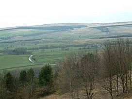
Hurst Hill is a location on Anglezarke Moor, within the West Pennine Moors of Lancashire, England. Despite a modest height of 317 metres (1040 feet), the summit provides excellent views towards the Irish Sea. Of more note, however, is its location between Round Loaf and Pikestones, both of which are Neolithic remnants. It is probable that Hurst Hill (and nearby Grain Pole Hill) were vantage points for the ancient communities. No excavation work has taken place.
External links[]
Coordinates: 53°39′23″N 2°33′41″W / 53.65628°N 2.56132°W
This Lancashire location article is a stub. You can help Wikipedia by . |
Categories:
- Geography of Chorley
- Mountains and hills of Lancashire
- Hills of the West Pennine Moors
- Lancashire geography stubs