Wheelton
| Wheelton | |
|---|---|
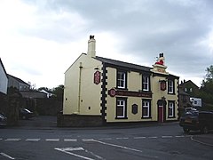 The Red Lion public house | |
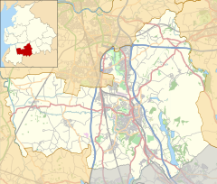 Wheelton Shown within Chorley Borough | |
| Population | 956 (2011 Census) |
| OS grid reference | SD603211 |
| Civil parish |
|
| District |
|
| Shire county | |
| Region | |
| Country | England |
| Sovereign state | United Kingdom |
| Post town | CHORLEY |
| Postcode district | PR6 |
| Dialling code | 01254 |
| Police | Lancashire |
| Fire | Lancashire |
| Ambulance | North West |
| UK Parliament | |

Wheelton is a village and civil parish of the Borough of Chorley, in Lancashire, England. According to the United Kingdom Census 2001 it has a population of 1,001, reducing to 956 at the 2011 Census.[1] The village is located on the A674 Chorley–Blackburn road.
There are two communities: Wheelton, which is close to the Leeds-Liverpool Canal and borders Whittle-le-Woods; and Higher Wheelton which is located on the road from Chorley to Blackburn. It is one of the more affluent parts of Lancashire owing to easy motorway access and a semi rural setting.[citation needed]
Wheelton Clock Tower is set in a garden at the centre of the village commemorating the men of Heapey and Wheelton who fell in the Great War in 1914-1918. The Grade II Listed memorial is made from local stone and was unveiled in 1922.[2]
See also[]
References[]
- ^ UK Census (2011). "Local Area Report – Wheelton Parish (E04005159)". Nomis. Office for National Statistics. Retrieved 27 May 2019.
- ^ "HEAPEY AND WHEELTON CLOCK TOWER". warmemorialsonline.org.uk. 20 September 2013. Retrieved 7 June 2021.
External links[]
| Wikimedia Commons has media related to Wheelton. |
This Lancashire location article is a stub. You can help Wikipedia by . |
- Geography of Chorley
- Villages in Lancashire
- Civil parishes in Lancashire
- West Pennine Moors
- Lancashire geography stubs