Ikema Island
This article needs additional citations for verification. (November 2011) |
Native name: Ikema-jima (池間島) | |
|---|---|
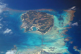
 Aerial view of Ikema-jima from southeast | |
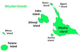
 Ikema Island is located to the north of Miyako Island | |
| Geography | |
| Location | Okinawa Prefecture |
| Coordinates | 24°55′N 125°15′E / 24.917°N 125.250°E |
| Archipelago | Miyako Islands |
| Area | 2.83 km2 (1.09 sq mi)[1] |
| Highest elevation | 28 m (92 ft) |
| Highest point | Unknown |
| Administration | |
Japan | |
| Demographics | |
| Population | 774[2] (2018) |
| Ethnic groups | Ryukyuan, Japanese |
Ikema Island (池間島, Ikema-jima, Miyako: Ikyaama (イキャーマ)), is located to the north of Miyako Island in Okinawa Prefecture, Japan. The island is connected to Miyako Island with a 1,425-metre-long (4,675 ft) bridge (池間大橋), which was completed in February 1992.[3][1] There is a pond in the centre of the island. To the north-east is the Ikema-jima Block Beach (池間島ブロックビーチ). The variety of Miyakoan language spoken here is also called Ikema (Ikima in the vernacular). It is set apart from closely related language variants by its lexical word-tone system.[4]
Ikema bridge connects Ikema Island with Miyako Island. It's 1,425-metre-long (4,675 ft).

Ikemajima Block Beach
See also[]
References[]
- ^ Jump up to: a b "Department of Land and Islands, Planning Department, Okinawa Prefecture (指定離島・指定離島一覧)" (PDF). Archived (PDF) from the original on 27 August 2019. Retrieved 30 January 2020.
- ^ "Ikema island tourism information site", , 2018. Retrieved on 13 January 2018.
- ^ "Ikema Ohashi", , 2018. Retrieved on 13 January 2018.
- ^ Shimoji, Michinori; Pellard, Thomas (2010). An Introduction to Ryukyuan Languages. Research Institute for Languages and Cultures of Asia and Africa. pp. 167–188. ISBN 978-4-86337-072-2.
Categories:
- Miyakojima, Okinawa
- Islands of Okinawa Prefecture
- Miyako Islands
- Okinawa geography stubs


