Illorsuit Island
 Location of Illorsuit Island | |
| Geography | |
|---|---|
| Location | Uummannaq Fjord |
| Coordinates | 71°10′N 53°43′W / 71.167°N 53.717°WCoordinates: 71°10′N 53°43′W / 71.167°N 53.717°W |
| Area | 468 km2 (181 sq mi) |
| Administration | |
Greenland | |
| Municipality | Avannaata |

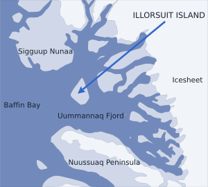
Illorsuit Island (Greenlandic: Illorsuip qeqertaat, Danish: Ubekendt Ejland) is an island in the Avannaata municipality in northwestern Greenland.
Geography[]

The southern part of Illorsuit Island seen across the northeastern part of Uummannaq Fjord, from the western ridge of the Nunaarssuaq mountain on the .
The island is pear-shaped, and at 468 km2 (180.7 sq mi),[1] it is the second-largest island in the Uummannaq Fjord system, located to the east of its mouth, between Sigguup Nunaa peninsula in the north and Nuussuaq Peninsula in the south.[2]
Settlement[]
Illorsuit is the only settlement on the island, located on the northeastern coast of the island.
References[]
- ^ Norwegian University of Science and Technology Archived 2011-06-15 at the Wayback Machine
- ^ Nuussuaq, Saga Map, Tage Schjøtt, 1992
This Greenland location article is a stub. You can help Wikipedia by . |
Categories:
- Islands of Greenland
- Uummannaq Fjord
- Greenland geography stubs