Nuussuaq Peninsula
 Nuussuaq Peninsula seen from Uummannaq | |
 Map of Nuussuaq Peninsula | |
 Nuussuaq Peninsula Location within Greenland | |
| Geography | |
|---|---|
| Location | Baffin Bay |
| Coordinates | 70°25′N 52°30′W / 70.417°N 52.500°WCoordinates: 70°25′N 52°30′W / 70.417°N 52.500°W |
| Area | 7,160 km2 (2,760 sq mi) |
| Length | 180 km (112 mi) |
| Width | 48 km (29.8 mi) |
| Highest elevation | 2,144 m (7034 ft) |
| Administration | |
| Municipality | Avannaata |

Nuussuaq Peninsula (Greenlandic pronunciation: [nuːsːuɑq], old spelling: Nûgssuaq) is a large (180x48 km)[1] peninsula in western Greenland.
Geography[]
The waters around the peninsula are that of Baffin Bay. To the south and southwest the peninsula is bounded by Disko Bay, an inlet of Baffin Bay. It is separated from Qeqertarsuaq Island by Sullorsuaq Strait which connects Disko Bay with Baffin Bay. To the northeast, it is bounded by the Uummannaq Fjord system.
The peninsula is mountainous, with the highest summit reaching 2,144 m.[2] The spinal range splits in two to the northwest of the base of the peninsula, with the southern arm forming the coastal range, the central arm almost entirely glaciated, and continuing northwest the entire length of the peninsula. The two arms are dissected by a deep , partially filled in the center with , a glacial, emerald lake.[2]
History[]
Archaeological excavations in Qilakitsoq on the southwestern shore revealed the existence of an ancient Arctic culture later named the Saqqaq culture that inhabited the area of west-central Greenland between 2500 BCE and 800 BCE.[3]
The world's largest fossil mollusk, Inoceramus steenstrup, was found in 1952 in Qilakitsoq Valley on the Nuussuaq peninsula.
Settlements[]
The peninsula is administered as part of the Avannaata municipality. The main settlements are Qaarsut and Niaqornat on the northwestern shore, Saqqaq on the southeastern shore, at the foot of the Livets Top mountain (1,150 m),[4] and Qeqertaq on a small island just off the southern shore, at the base of the peninsula.
Photographs[]

Qilertiinguit Kangilequtaa (2070m)[2] seen from Uummannaq across the main arm of Uummannaq Fjord

Chasm couloir above the northeastern shore. Seen from Uummannaq.
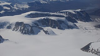
Aerial view: Nunavik and the blanket glacier covering a large part of the northern chain of the central mountain range, north of Auvarrssuaq valley.

Aerial view of Sarqap Tassersuaq, the emerald lake in the central valley
References[]
- ^ Encyclopædia Britannica. "Nuussuaq". Retrieved 2009-02-12.
- ^ a b c Nuussuaq, Saga Map, Tage Schjøtt, 1992
- ^ "Archived copy". Archived from the original on 2011-04-19. Retrieved 2011-04-19.CS1 maint: archived copy as title (link) The Greenland Research Centre at the National Museum of Denmark
- ^ O'Carroll, Etain (2005). Greenland and the Arctic. Lonely Planet. p. 180. ISBN 1-74059-095-3.
External links[]
| Wikimedia Commons has media related to Nuussuaq Peninsula. |
- Disko Bay
- Peninsulas of Greenland
- Uummannaq Fjord