Qaarsut
Qaarsut | |
|---|---|
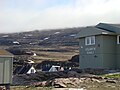
 Aerial panorama of Qaarsut | |
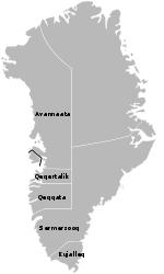
 Qaarsut Location within Greenland | |
| Coordinates: 70°43′55″N 52°38′15″W / 70.73194°N 52.63750°WCoordinates: 70°43′55″N 52°38′15″W / 70.73194°N 52.63750°W | |
| State | |
| Constituent country | |
| Municipality | |
| Government | |
| • Mayor | Ole Dorph |
| Population (2020) | |
| • Total | 174 |
| Time zone | UTC-03 |
| Postal code | 3964 Qaarsut |

Qaarsut (old spelling: Kaersut) is a settlement in the Avannaata municipality, in northwestern Greenland. It is situated on the northeastern shore of the Nuussuaq Peninsula. It had 174 inhabitants in 2020.[2]
History[]
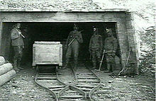
The Qaarsuarsuit coal mine in 1907
The first coal mine in Greenland operated between 1778 and 1924 in Qaarsuarsuit.
Transport[]
Qaarsut Airport, located to the northwest of the settlement, serves both Qaarsut and Uummannaq, the latter accessible only by helicopter.
Population[]
The population of Qaarsut has dropped by over 18 percent relative to the 2000 levels, reflecting a general trend in the region.[3]

Photos[]
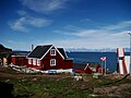
Qaarsut's chapel

Qaarsut and Uummannaq's mountain in the background

Overview of Qaarsut
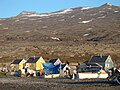
Colourful houses
School

Qaarsut at midnight sun


References[]
| Wikimedia Commons has media related to Qaarsut. |
- ^ Kalaallit Nunaata Radioa (Greenlandic Broadcasting Corporation) (in Danish)
- ^ "Population by Localities". Statistical Greenland.
- ^ Jump up to: a b Statistics Greenland Archived July 21, 2011, at the Wayback Machine
| Authority control |
|
|---|
Categories:
- Populated places in Greenland
- Populated places of Arctic Greenland
- Qaasuitsup
- Uummannaq Fjord