Indas
Indas | |
|---|---|
Village | |
 Indas Location in West Bengal, India | |
| Coordinates: 23°09′10.8″N 87°37′55.2″E / 23.153000°N 87.632000°ECoordinates: 23°09′10.8″N 87°37′55.2″E / 23.153000°N 87.632000°E | |
| Country | |
| State | West Bengal |
| District | Bankura |
| Population (2011) | |
| • Total | 50,000 |
| Languages | |
| • Official | Bengali, English |
| Time zone | UTC+5:30 (IST) |
| PIN | 722205 (Indas) |
| Telephone/STD code | 03244 |
| Lok Sabha constituency | Bishnupur |
| Vidhan Sabha constituency | Indas |
| Website | bankura |


Indas (also spelled Indus) is a village, with a police station, in the Indas CD block in the Bishnupur subdivision of the Bankura district in the state of West Bengal, India.
Geography[]
M: Municipal town, CT: census town, R: rural/ urban centre, T: ancient/ temple centre
Owing to space constraints in the small map, the actual locations in a larger map may vary slightly
Location[]
Indas is located at 23°09′10.8″N 87°37′55.2″E / 23.153000°N 87.632000°E.
Area overview[]
The map alongside shows the Bishnupur subdivision of Bankura district. Physiographically, this area has fertile low lying alluvial plains.[1] It is a predominantly rural area with 90.06% of the population living in rural areas and only 8.94% living in the urban areas.[2] It was a part of the core area of Mallabhum.[3]
Note: The map alongside presents some of the notable locations in the subdivision. All places marked in the map are linked in the larger full screen map.
Demographics[]
As per 2011 Census of India Indas had a total population of 2,479 of which 1,284 (52%) were males and 1,195 (48%) were females. Population below 6 years was 256. The total number of literates in Indas was 1,440 (64.78% of the population over 6 years).[4]
Civic administration[]
Police station[]
Indas police station has jurisdiction over Indas CD block. The area covered is 255.10 km2 with a population of 152,829.[5][6]
CD block HQ[]
The headquarters of Indas CD block are located at Indas.[7]
Transport[]
Indas railway station, 68.5 km from Bankura, is a station on the Bankura-Masagram line (formerly Bankura Damodar Railway) of South Eastern Railway. As of September 2016, DEMU services were available between Bankura and Mathnasibpur.[8] Bankura -Masagram line ( formerly B.D.R) expanded from October 2017 to Masagram Junction.
Education[]
Indas Mahavidyalaya is a coeducational institution affiliated to the . It was established in 2006 and offers courses in arts and science.[9] Now Indas Mahavidyalaya is affiliated to Bankura University from the year 2017-2018 educational year.
Indas High School is a Bengali medium boys school established in 1893. It is a higher secondary school (classes 6 to 12). It is a government school.[10]
Indas Girls High School is a Bengali medium higher secondary school (classes 6 - 12) for girls, established in 1956. It is a government school. It has 9 class rooms, 19 teachers and 10 computers.[11]
Culture[]
David J. McCutchion mentions the Radha Damodara temple of the Sarkar family as a navaratna temple with terracotta façade built in 1796.[12]
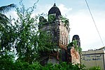
Nabaratna Damodara temple (partially damaged)

Terracotta plaque


Healthcare[]
Indas Rural Hospital, with 30 beds at Indas, is the major government medical facility in the Indas CD block. There are primary health centres at Akui (with 4 beds), Keneti (Santasram Indus) (with 10 beds) and Dighalgram (with 6 beds).[13][14]
References[]
- ^ "District Census Handbook Bankura" (PDF). pages 13-17. Directorate of Census Operations West Bengal. Retrieved 23 April 2020.
- ^ "District Statistical Handbook 2014 Bankura". Table 2.4b. Department of Statistics and Programme Implementation, Government of West Bengal. Retrieved 23 April 2020.
- ^ O'Malley, L.S.S., ICS, Bankura, Bengal District Gazetteers, pp. 21–46, 1995 reprint, first published 1908, Government of West Bengal
- ^ "2011 Census – Primary Census Abstract Data Tables". West Bengal – District-wise. Registrar General and Census Commissioner, India. Retrieved 14 October 2016.
- ^ "District Statistical Handbook 2014 Bankura". Tables 2.1, 2.2. Department of Planning and Statistics, Government of West Bengal. Retrieved 15 May 2020.
- ^ "Indas PS". Bankura District Police. Retrieved 14 October 2016.
- ^ "District Census Handbook: Bankura" (PDF). Map of Bankura with CD lock HQs and Police Stations (on the fifth page). Directorate of Census Operations, West Bengal, 2011. Retrieved 20 November 2016.
- ^ "Bankura-Mathnasibpur DEMU". Time Table. indiarailinfo. Retrieved 15 October 2016.
- ^ "Indas Mahavidyalaya". College Admission. Retrieved 11 December 2016.
- ^ "Indas High School". ICBSE. Retrieved 11 December 2016.
- ^ "Indas Girls High School". ICBSE. Retrieved 11 December 2016.
- ^ McCutchion, David J., Late Mediaeval Temples of Bengal, first published 1972, reprinted 2017, page 54. The Asiatic Society, Kolkata, ISBN 978-93-81574-65-2
- ^ "Health & Family Welfare Department" (PDF). Health Statistics – Rural Hospitals. Government of West Bengal. Retrieved 10 April 2020.
- ^ "Health & Family Welfare Department" (PDF). Health Statistics – Primary Health Centres. Government of West Bengal. Retrieved 10 April 2020.
External links[]
| Wikimedia Commons has media related to Indas. |
Cities, towns and locations in Bankura District, Medinipur division | ||||||||
|---|---|---|---|---|---|---|---|---|
| Cities, municipal and census towns |
|  Divisions of West Bengal | ||||||
| Locations other than cities and towns |
| |||||||
| Related topics |
| |||||||
- Villages in Bankura district