Patit Dommahal
Patit Dommahal | |
|---|---|
Village | |
 Patit Dommahal Location in West Bengal, India | |
| Coordinates: 23°09′57″N 87°34′18″E / 23.1657°N 87.5717°ECoordinates: 23°09′57″N 87°34′18″E / 23.1657°N 87.5717°E | |
| Country | |
| State | West Bengal |
| District | Bankura |
| Population (2011) | |
| • Total | 2,061 |
| Languages | |
| • Official | Bengali, English |
| Time zone | UTC+5:30 (IST) |
| PIN | 722206 |
| Telephone/STD code | 03244 |
| Lok Sabha constituency | Bishnupur |
| Vidhan Sabha constituency | Indas |
| Website | bankura |


Patit Dommahal is a village in the Patrasayer CD block in the Bishnupur subdivision of the Bankura district in the state of West Bengal, India.
Geography[]
M: Municipal town, CT: census town, R: rural/ urban centre, T: ancient/ temple centre
Owing to space constraints in the small map, the actual locations in a larger map may vary slightly
Location[]
Patit Dommahal is located at 23°09′57″N 87°34′18″E / 23.1657°N 87.5717°E.
Note: The map alongside presents some of the notable locations in the subdivision. All places marked in the map are linked in the larger full screen map.
Demographics[]
According to the 2011 Census of India, Patit Dommahal had a total population of 3,971, of which 1,983 (50%) were males and 1,988 (50%) were females. There were 404 persons in the age range of 0–6 years. The total number of literate persons in Patit Dommahal was 2,372 (66.50% of the population over 6 years).[1]
Education[]
Patit High School is a Bengali-medium coeducational institution established in 1955. It has facilities for teaching from class V to class XII. The school has 10 computers, a library with 2,300 books and a playground.[2]
Patrasayer Mahavidyalaya was established in 2005 at Patrasayer[3][4]
Culture[]
David J. McCutchion mentions the Sridhara temple of the Rakshit family as a low towered at-chala, having 12’2’’ square base, brick built with terracotta façade, constructed in the 19th century.[5]
Patit picture gallery[]

Sridhar temple

Terracotta panel
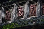
Terracotta panel
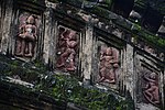
Terracotta panel


Healthcare[]
Patrasayer Rural Hospital, with 30 beds at Hat Krishnanagar, is the major government medical facility in the Patrasayer CD block. There is a primary health centre at Balsi, with 10 beds.[6][7]
References[]
- ^ "CD block Wise Primary Census Abstract Data(PCA)". West Bengal – District-wise CD blocks. Registrar General and Census Commissioner, India. Retrieved 20 April 2020.
- ^ "Patit HS". Schools.org.in. Retrieved 4 May 2020.
- ^ "Patrasayer Mahavidyalaya". Patrasayer Mahavidyalaya. Archived from the original on 6 January 2017. Retrieved 29 November 2016.
- ^ "Patrasayer Mahaviyalaya". College Admission. Retrieved 6 March 2018.
- ^ McCutchion, David J., Late Mediaeval Temples of Bengal, first published 1972, reprinted 2017, page 33. The Asiatic Society, Kolkata, ISBN 978-93-81574-65-2
- ^ "Health & Family Welfare Department" (PDF). Health Statistics – Rural Hospitals. Government of West Bengal. Retrieved 10 April 2020.
- ^ "Health & Family Welfare Department" (PDF). Health Statistics – Primary Health Centres. Government of West Bengal. Retrieved 10 April 2020.
External links[]
| Wikimedia Commons has media related to Patit Dommahal. |
Cities, towns and locations in Bankura District, Medinipur division | ||||||||
|---|---|---|---|---|---|---|---|---|
| Cities, municipal and census towns |
|  Divisions of West Bengal | ||||||
| Locations other than cities and towns |
| |||||||
| Related topics |
| |||||||
- Villages in Bankura district